

The first Sunday of spring will indeed be spring-like, with plenty of sunshine and above-normal temperatures.
But from Monday afternoon and from the west, showers and thunderstorms are expected, according to ERT meteorologist Panagiotis Giannopoulos.
The deterioration of the weather will be temporary.
For example, in Attica it will rain shortly after midnight Monday to Tuesday, but by the time dawn breaks the weather in Attica will have already improved.
The system has a very fast movement from the west, in the east it will cross the country in about 12 hours.
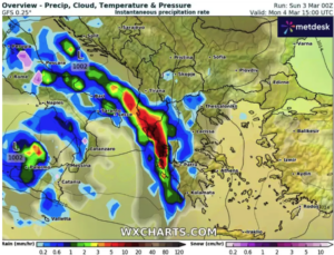
However, it will also snow on Monday night in the central and northern mountains.
The next showers are forecast in the north and northeast of the country on Thursday and Friday morning where temperatures will drop a little.
In particular, according to the forecast, clouds are expected for today, Sunday, partly cloudy in the morning in the eastern Aegean islands, eastern Macedonia and Thrace, and in the afternoon in the rest of the mainland and Crete, when local rain or rain and in the northeastern mainland isolated thunderstorms will occur.
Visibility in the morning and evening hours will be locally limited and fog will form in places, mainly in the west and north.
Winds will blow in the south from westerly directions at 4 to 6 Beaufort. In the rest of the country it will be variable 3 to 4 Beaufort and gradually southerly with the same intensity.
The temperature will not change significantly. It will reach 16 to 17 degrees Celsius in the northern mainland and 18 to 19 degrees Celsius in the rest of the country.
MACEDONIA, THRACE
Weather: in eastern Macedonia and Thrace, clouds, partly cloudy with local showers and isolated thunderstorms in the early morning hours and again in the afternoon, while improvement is expected from the evening. In the remaining areas, a few clouds, partly increasing in the afternoon and evening hours, with localised showers and possibly occasional rain.
Winds: Variable 3 to 4 Beaufort.
Temperature: From 07 to 17 degrees Celsius. In western Macedonia the minimum will be 3 to 4 degrees lower.
IONIAN ISLANDS, EPIRUS, WESTERN SOLID, WESTERN PELOPONNESE, WESTERN PELOPONNESE.
Weather: a few clouds in the midday and afternoon hours in the continental areas, when local rain or occasional rain is possible.
Winds: Variable 3 to 4 Beaufort and gradually in the north south to 5 Beaufort and in the south west with the same intensity.
Temperature: From 09 to 18 degrees Celsius. In the interior of Epirus 3 to 5 degrees lower.
EASTERN SOLIDIA, EUBOEA, EASTERN PELOPONNESE
Weather: a few clouds, partly cloudy and partly cloudy in the afternoon and evening hours, with the possibility of local rain or occasional rain in the mountains.
Winds: From westerly directions 3 to 5 and in the south locally up to 5 Beaufort.
Temperature: From 07 to 19 degrees Celsius.
CYCLADES, CRETE.
Weather: a few clouds, partly cloudy, mainly in the midday and afternoon hours in Crete, with local rain or rain in the mountains.
Winds: From westerly directions 4 to 6 Beaufort.
Temperature: From 13 to 19 degrees Celsius.
EASTERN AEGEAN ISLANDS – DODECANESE
Weather: clouds in the eastern Aegean islands, increasing in places until noon, when local showers will occur.
Winds: In the eastern Aegean islands variable 3 to 4 Beaufort. In the Dodecanese from westerly directions 3 to 5 Beaufort from the west.
Temperature: From 12 to 19 degrees Celsius.
THESSALY
Weather: a few clouds, partly increasing in the midday and afternoon hours, when local rain or occasional rain in the mountains is possible.
Winds: Variable 3 to 4 Beaufort and from the evening south with the same intensity.
Temperature: From 05 to 17 degrees Celsius.
The drilling rig sets to work on the deposits of Crete
ATTICA
Weather: light clouds, occasionally denser in the midday and afternoon hours.
Winds: From westerly directions 3 to 4 Beaufort and gradually variable with the same intensity.
Temperature: From 12 to 18 degrees Celsius.
THESSALONIKI
Weather: a few clouds, partly cloudy and partly cloudy.
Winds: Variable 3 to 4 Beaufort.
Temperature: From 09 to 17 degrees Celsius.
FORECAST FOR TOMORROW MONDAY 04-03-2024
In central and eastern Macedonia, Thrace, the eastern Aegean islands and the Dodecanese, partly cloudy with the possibility of local rain in the early morning and in the rest of the country a few local clouds.
From the midday, clouds will increase initially in the west and gradually in the central and northern regions, with showers, while thunderstorms will occur in the Ionian Sea and the western mainland from the afternoon and later in the north.
Visibility in the morning hours will be locally limited.
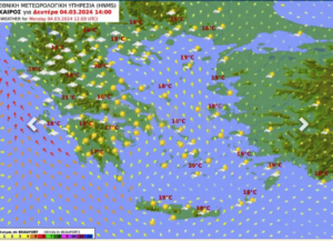
Meteorological conditions favour the transport of African dust mainly in the central and southern regions.
Winds will blow from southerly directions from 4 to 6 Beaufort and gradually in the sea up to 7 Beaufort.
From the afternoon in the west it will turn into westerly winds up to 6 Beaufort.
The temperature will reach 14 to 16 degrees Celsius in the northern mainland and 18 to 20 degrees Celsius in the rest of the country.