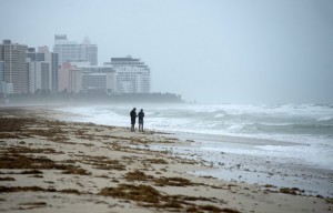
Hurricane Irma’s winds have started whipping Florida as the storm spins on a new track that puts Tampa — not Miami — in its crosshairs.
The U.S. National Hurricane Center in Miami said early Sunday morning that Irma had strengthened back into a Category 4 storm, with sustained winds of 130 mph. Forecasters expected the storm to pick strength back up as it moved away from Cuba and toward the Florida Keys.
Irma’s powerful center was located about 55 miles south-southeast of Key West, Florida, as of 4 a.m. Sunday. The storm left at least 27 people dead across the Caribbean.
Meteorologists say damaging winds from Irma’s outer bands were already arriving in South Florida. The storm was expected to reach the Florida Keys later Sunday morning before moving up the state’s Gulf Coast.
“Life-threatening storm surge expected in the Florida keys and the west coast of Florida,” the Hurricane Center warned, and hurricane warnings were in effect for Fernandina Beach southward around the Florida peninsula to Indian Pass, all of the Florida Keys, Lake Okeechobee and Florida Bay.
More than 5 million people across Florida have been ordered to evacuate and thousands crammed into shelters. Gov. Rick Scott (R) sounded dire warnings about the storm, urging residents in evacuation zones to leave their homes immediately.
“Once the storm starts, law enforcement cannot save you,” Scott said at a news conference in Sarasota.
The eye of the storm is now expected to head up the state’s west coast, rather than the middle, so Naples, Fort Myers and Tampa will likely bear the brunt. But because of the size of the hurricane, Florida’s east coast remains in danger, including from storm surges that will easily overwhelm some areas. But before the storm reaches the peninsula, the Florida Keys will experience its full force.
While the National Hurricane Center had downgraded Irma to a Category 3 storm Saturday, the storm was upgraded again to Category 4 at 2 a.m. on Sunday, with maximum sustained winds near 130 miles per hour. According to an advisory issued late Saturday night, the forecast track indicated that Irma’s center was expected to cross the Lower Keys on Sunday morning. On Sunday afternoon through Monday morning, it was expected to move near or along the state’s west coast.
The storm should head inland and hit the Florida Panhandle and part of Georgia on Monday afternoon, the advisory stated.
Ed Rappaport, acting director of the National Hurricane Center, said Hurricane Irma is “still a dangerous Category 3 storm.”
The slow-moving storm could intensify a bit before it is expected to directly hit the Florida Keys around daybreak Sunday, potentially passing the 130 mph wind speed thresholdto become a Category 4 storm. The Keys could experience hurricane-force winds for six hours and tropical storm winds for at least twice that amount of time, Rappaport said.
source: washingtonpost.com, cbsnews.com
Ask me anything
Explore related questions


