Friday is expected to be difficult in terms of African dust especially for the west and south as there are expected to be more concentrations near the ground as the presence of low pressure in the Western Mediterranean combined with higher atmospheric pressure values over our region will lead to the transfer of warm air masses from Africa to our country.
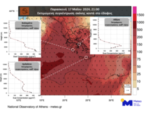
According to the dust concentration forecast model of the National Observatory of Athens/meteo.gr, for the weather tomorrow, Friday (17/05), increased dust concentrations are expected near the ground in the western and southern parts of our country, while in the central and northern parts the highest concentrations will be located at higher altitudes.
The map below shows the estimated dust concentrations near the ground for the evening hours of Friday in the whole country, while the integrated diagrams show the dust concentrations at altitude in three selected cities (Athens, Kalamata, Heraklion).
Watch a video of the temperature evolution at a height of about 1500 m above mean sea level, the level at which the movement of gas masses is studied, and the concentration of dust low in the atmosphere as predicted by the numerical forecast models of the National Observatory of Athens/meteo.gr until Monday 20/5.
Significant temperature rise and dust transport episode 15 – 20 May 2024

EMY forecast:
For tomorrow, Friday, thin clouds, sometimes more dense, mainly in the southern parts of the country. Visibility in the morning hours on the mainland will be locally limited. Meteorological conditions favour the transport of African dust, mainly in the west and south.
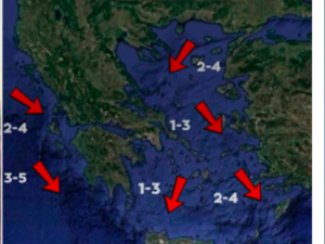
Winds in the northern and central Aegean Sea will blow northeast at 4 to 5 and locally up to 6 Beaufort. In the rest of the country it will be south southeastern 4 to 6 and locally in the Ionian Sea 7 Beaufort. Gradual weakening from the afternoon. The temperature will rise and will reach 22 to 24 degrees Celsius in the north, 28 to 30 degrees Celsius in the west, 26 to 29 degrees Celsius in the central and south and 33 degrees Celsius in northern Crete.
On Saturday, the weather will be almost clear with sparse clouds, occasionally more dense in the west. Local showers will occur in the afternoon and evening hours in the west. Visibility in the morning hours on the mainland will be locally limited. Meteorological conditions favour the transport of African dust, mainly in the west and south.
Winds will be in the west south southeast at 3 to 5 Beaufort. In the rest of the country variable 3 to 4 Beaufort and in the Aegean Sea winds will blow from the north with the same intensity. The temperature will rise further and will reach in the north 27 to 29 degrees Celsius, in the west, central and south 29 to 32 and locally 33 degrees Celsius.
On Sunday, thin clouds, occasionally more dense, mainly in the north, central and Crete. Local showers and isolated thunderstorms will occur in the morning hours in the northern parts of the country.
Mitsotakis from Chios: Political stability is the stake of the European elections
Meteorological conditions favour the transport of African dust, mainly in the west and south. Winds will blow in the west and south southeast at 3 to 5 Beaufort, and occasionally up to 6 Beaufort in the morning hours. In the rest of the country it will be variable 3 to 4 Beaufort. Temperatures will rise slightly further, mainly in the west, central and northern regions.
On Monday, almost clear weather with sparse clouds, sometimes more dense mainly in the northern mainland and the Peloponnese. Local showers and possibly isolated thunderstorms will occur mainly in the northern mainland. Visibility in the morning hours in the continental areas will be locally limited.
Meteorological conditions favour the persistence of African dust, mainly in the west and south. Winds will be variable 3 to 4 Beaufort and in the Ionian Sea east southeast 3 to 5 Beaufort. Temperatures will rise mainly in the south.
Ask me anything
Explore related questions


