Today and tomorrow, the weather will be spring-like, with February making its debut with extended sunny spells and temperatures reaching up to 19°C.
However, from Monday onwards, the weather will take a turn for the worse, with temperatures dropping 3-6 degrees below normal levels and northern winds strengthening, as noted by EMY’s director, Theodoros Kolydas, in a post. “Rain will mainly affect the ‘northern stream’ areas (eastern and southern regions). There is also a noticeable trend of low-pressure formation in the Central Mediterranean after the first ten days, which typically brings a lot of rain,” the meteorologist explains.
ΤΑ ΚΑΛΑ ΝΕΑ ΤΗΣ ΕΡΧΟΜΕΝΗΣ ΕΒΔΟΜΑΔΟΣ- "Ο ΦΛΕΒΑΡΗΣ ΘΑ ΦΛΕΒΙΣΕΙ…"
— Theodoros Kolydas (@KolydasT) January 31, 2025
Ο Φεβρουάριος σύμφωνα με το λαογράφο ετυμολόγο σημαίνει πρησμένη φλέβα και τούτο επειδή κατά το μήνα αυτόν πρήζονται, γεμίζουν με νερό οι φλέβες της γης.
✅Οι θερμοκρασίες από τα μέσα της ερχόμενης εβδμάδος θα… pic.twitter.com/tHJqTz53yf
Deterioration from Monday
A new bout of bad weather is expected to impact the country next week, bringing rain and strong storms, moving from the west towards the east.
Specifically, from Monday, February 3, 2025, a fresh wave of significant rainfall and localized thunderstorms will begin, while on Tuesday (4/2), meteorologists predict a moderately intense cold wave bringing weather disturbances to the eastern and southern regions.
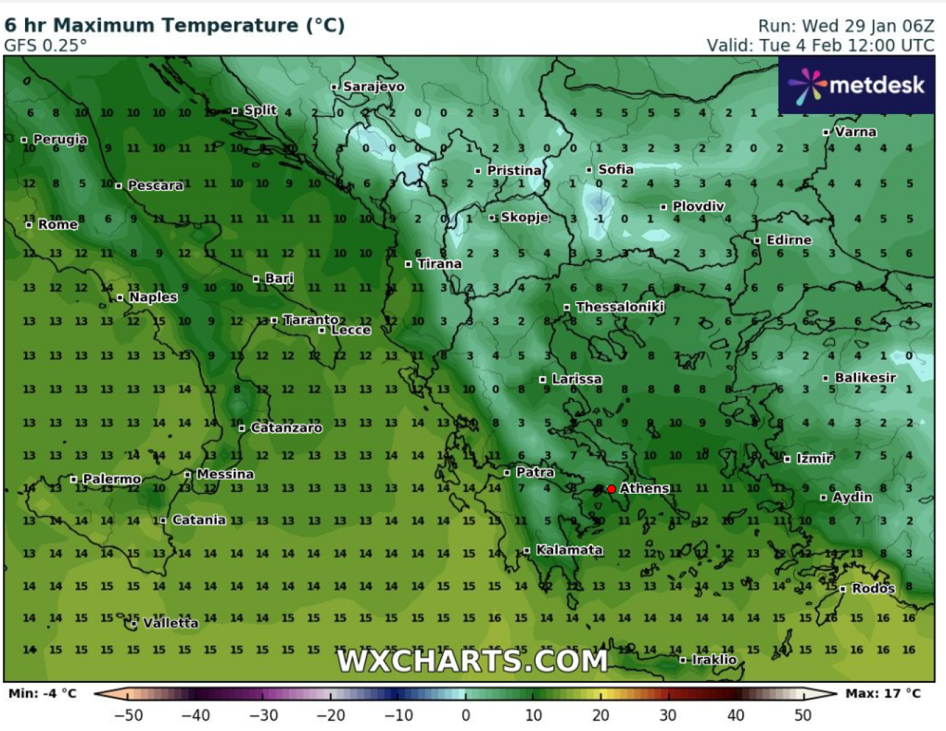
Weather: Cold Wave Arrives Next Tuesday – When the ‘Halcyon Days’ End, What Meteorologists Say
The weather in the coming days will remain relatively stable, but February is set to make an aggressive entrance with the return of heavy storms and cold conditions. Meteorologists Kostas Lagouvardos, Sakis Arnaoutoglou, and Tasos Arniakos all agree that a cold wave will hit in early February, bringing chillier temperatures and snow.
According to Tasos Arniakos, the second month of the year will usher in colder conditions, with both low temperatures and snowfall. It seems that from early February, the ‘Halcyon Days’ and the sunny weather across most of the country will come to an end.
Even Kostas Lagouvardos estimates that the entire country will experience a significant drop in temperatures starting next week.
Marousakis: ‘From Tuesday, the Cold Will Intensify’
A shift in the weather is expected from the early days of February, particularly from the 4th of the month onwards. This is also supported by meteorologist Klearchos Marousakis, who does not rule out a severe cold snap but notes that it is still too early to make any firm predictions.
Today’s Weather
Cloud cover will vary across different areas, with long sunny intervals. Dust concentrations in the atmosphere will be relatively high over northern mainland regions and the northern Aegean. Visibility will be locally limited, both in the early morning hours and towards the end of the day.
Temperatures will range from:
- Western Macedonia: -1°C to 11°C
- Rest of Macedonia & Thrace: 3°C to 16°C
- Thessaly: 4°C to 16°C
- Epirus: 1°C to 17°C
- Central Greece: 4°C to 17°C
- Peloponnese: 3°C to 18°C
- Ionian Islands: 6°C to 16°C
- Northern & Eastern Aegean Islands: 6°C to 18°C
- Cyclades: 7°C to 17°C
- Dodecanese: 12°C to 17°C
- Crete: 6°C to 20°C
Winds:
In the Aegean: Northern directions at 2-4 Beaufort
In the Ionian: Initially variable up to 3 Beaufort, shifting to southerly at 2-4 Beaufort by evening
Athens Forecast: Local clouds expected from midday. Winds will be variable up to 3 Beaufort. Visibility will be locally limited both in the early morning hours and later at night. Temperature in central Athens will range from 11°C to 17°C.
Thessaloniki Forecast: Mostly clear with occasional local clouds. Winds will be variable up to 2 Beaufort. Visibility will be locally limited both in the early morning hours and towards the end of the day. Dust concentrations in the atmosphere will be relatively high. Temperature in central Thessaloniki will range from 8°C to 15°C.
Weather on Sunday, 02-02-2025
In the west, central, and northern regions, increased cloud cover with local rain in the Ionian and, from early afternoon, in Epirus, western Central Greece, and western Peloponnese, later spreading to western and central Macedonia. Isolated thunderstorms will occur in northwestern areas. Elsewhere, mostly clear skies with a few clouds, increasing locally from the afternoon, with rain expected in eastern Peloponnese. Light snowfall will be observed in the northwestern mountainous regions from midday onwards. Visibility in inland areas will be locally limited during morning hours.
Winds:
In the west: Southeast at 5-6 Beaufort, locally reaching 7 Beaufort in the Ionian.
In the east: Easterly at 3-5 Beaufort.
Temperature: Will remain above seasonal averages, reaching 14-15°C in northern and central regions, 16-18°C in the rest of the country, and up to 19-20°C in southern island areas.
Weather on Monday, 03-02-2025
In Crete, the Dodecanese, the Cyclades, eastern Macedonia, and Thrace, increasing clouds will bring local showers from the afternoon. Elsewhere, cloud cover will be more pronounced, bringing rain and scattered thunderstorms. Snow will fall in central and northern mountainous areas. Winds: From southerly directions at 4-5 Beaufort, shifting to northeasterly in the northeast by midday, strengthening to 6-7 Beaufort by night. Temperature: Will begin to drop in the north, becoming notably cooler from the afternoon onwards.
Ask me anything
Explore related questions