Cold and wintry weather is expected through at least Thursday, with northerly winds and showers, and low temperatures.
According to EMY director Theodore Kolydas, “until the middle of next week, single-digit maximum temperatures, meaning values 4 to 5 degrees below normal levels. From Thursday onwards there is a tendency to rise”.
Down to -10°C yesterday morning
Very low minimum temperatures were recorded in the early hours of Sunday 09/02 with the mercury dropping below -10 degrees Celsius. The lowest temperature was recorded at Fort Nefrokopi with -10.3 °C. According to the network of automatic weather stations of the National Observatory of Athens / meteo.gr the eight lowest minimum temperatures of the day are presented in the table below.
Today’s weather
A few clouds are expected, which will be locally denser, especially in the eastern mainland, in Evia and Crete where there will be some light rain or sleet in the lowlands and light snowfall in the mountains. Slightly more frequent in Crete. At night and early in the morning in the continental areas frost will occur, while in the central and northern areas visibility will be limited and fog will form.
The temperature will range in Western Macedonia from -8 to 4 degrees, in the rest of northern Greece from -4 to 8 degrees, in Epirus from -2 to 11-12 degrees, in the western and southern mainland from 1 to 12-13 degrees, in Thessaly and North Central Greece from -3 to 8-9 degrees, in the rest of the eastern continent from 1 to 10 degrees, in the Ionian Islands from 5 to 13 degrees, in the North Aegean islands from 2 to 7-8 degrees and in the rest of the Aegean islands and in Crete from 5 to 10-12 degrees.
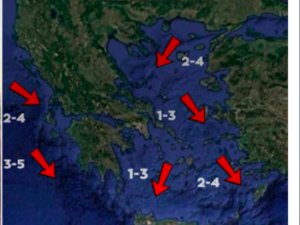
In the North Aegean, northeastern winds with intensities of 5-6 Beaufort and in the rest of the Aegean north winds with the same intensities and possibly locally in the southernmost seas 7 Beaufort. In the Ionian Sea winds will blow from the east with intensities of 3-5 Beaufort.
In Attica we expect a few clouds, occasionally increasing mainly in the north and east with the possibility of a few light showers and some snow in Parnitha. Winds will blow north northeast at 4-5 Beaufort and locally in the east at 6 Beaufort. The temperature will range from 5 to 8-9 degrees Celsius.
In Thessaloniki we expect a few clouds and limited visibility at night and early in the morning. Winds will blow from variable directions with intensities of 2-3 Beaufort. The temperature will range from 2 to 7 degrees Celsius.
The weather on Tuesday (11.02.2025)
In eastern Macedonia, Thrace and the Dodecanese a few clouds. In the rest of the country, partly cloudy with light local showers, which will gradually increase in the afternoon in the Ionian Sea, Epirus, western Thessaly and western and central Sterea. Light snowfall will occur in places in the mainland mountains and in the mountains of Evia and Crete.
Winds will blow in the west from east directions 3 to 4 Beaufort, in the east north northeast 4 to 6 Beaufort and in the central and southern Aegean Sea locally up to 7 Beaufort.
The temperature will not change significantly and will remain lower than normal for the season. In the Ionian Islands, the western and southern mainland, Crete, the Dodecanese and the southernmost islands of the Cyclades it will reach 11 to 13 degrees Celsius, in the rest of the country it will not exceed 08 to 10 degrees Celsius. Frost will occur locally on the mainland in the morning and evening hours, in the north in places strong.
The weather on Wednesday (12.02.2025)
In eastern Macedonia, Thrace and the Dodecanese a few clouds. In the rest of the country, clouds will be partly cloudy with local rainfall that will intensify from the afternoon in the Ionian Sea and possibly isolated thunderstorms. Snowfall will occur in the continental mountains and in the mountains of Evia and Crete.
Winds will blow in the west east southeastern 4 to 6 Beaufort, in the east north northeastern 4 to 6 and in the southeastern Aegean Sea locally 7 Beaufort.
Southwest to north-east and north-east to north-east and north-east to south-east, with south-eastern and south-eastern sea breezes and north-eastern sea breezes.
The temperature will not change significantly. Frost will occur in places on the continental areas in the morning and evening hours.
The weather on Thursday 13-02-2025
Partly cloudy, with local rain in the west, central and south. Sporadic thunderstorms are likely to occur on the Ionian Islands and the western Peloponnese. Snowfall will occur in the continental mountains and in the mountains of Crete.
Winds will blow in the west southeast at 4 to 6 and in the Ionian Sea locally 7 Beaufort, in the east from the north 3 to 5 and in the southeastern Aegean Sea locally 6 Beaufort with gradual weakening.
From the north-east to the south-east and from the south-east to the south-east, with a slight breeze and weakening in the south-east and south-eastern parts of the sea.
The temperature will rise slightly. Frost will occur in places on the continental areas in the morning and evening hours.
The weather on Friday 14-02-2025
Cloudy, with local rain mainly in the Ionian Sea, the central and southern continent and gradually on the Aegean islands. Sporadic thunderstorms are likely to occur mainly in the Ionian Sea. Light snowfall will occur in places in the continental highlands. Visibility in the morning and evening hours will be locally limited.
Winds will blow from southern directions 3 to 5 Beaufort.
The temperature will rise.
Ask me anything
Explore related questions


