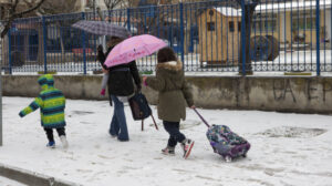
The severe weather front “Coral” is sweeping across the country, bringing a deep freeze, snowfall, and biting cold, with most regions expected to plunge into a deep freeze over the next 24 hours.
The cold wave is expected to last at least until Sunday, with temperatures set to drop by 10°C and snow falling at very low altitudes.
Among the areas expected to see snowfall are Thessaly, Central and Eastern Sterea, Euboea, northeastern Peloponnese, the islands of the central and southern Aegean, and the northern part of Attica, according to meteorologist Giannis Kallianos on Mega TV.
As for Athens, Friday and Saturday will be the coldest days, with temperatures in the city center not exceeding 6–7°C. According to the meteorologist, snow will fall from the Olympic Stadium (OAKA) and further north, but not in such intensity that it will accumulate and keep people indoors. Additionally, no snowfall is expected within the city of Thessaloniki.
In a social media post, Kallianos breaks down the advance of severe weather “Coral.”
LOW TEMPERATURES AND SELECTIVE SNOWFALL FOR 100 HOURS
From today, Thursday, until Sunday, the weather will be marked by very low temperatures, as the cold air mass will affect the country, even in the southernmost island regions. Frost will be particularly severe in the mountainous areas of the mainland, with minimum temperatures in northern Greece (mountainous areas) dropping below -10°C.
SELECTIVE SNOWFALL
In general, snowfall will not be heavy in most regions, though certain areas will experience slightly more intense snow showers at times.
Specifically, snowfall is expected to be slightly more intense at times in the following areas:
- Pieria
- Eastern and Southern Thessaly
- Central and Eastern Sterea (mainly Fthiotida and Boeotia)
- Euboea
- Sporades
- Cyclades
- Crete (mountainous and semi-mountainous areas, and possibly even lower altitudes in some cases)
By Sunday, more areas may be affected, but we will analyze this in future updates as it is still too early to confirm.
THE SITUATION IN ATTICA
In Attica, the weather will fluctuate, with periods of denser cloud cover alternating with clear skies. When the clouds thicken, localized snowfall will occur, mostly weak, primarily affecting the following areas:
- Northwest Attica
- Northern Attica
- Northeastern Attica
- Eastern Attica
Localized snowfall may occur even at altitudes as low as 150–200 meters, meaning quite low elevations. However, these will generally be weak, while in the northern parts of the region and near mountainous areas, they may be slightly more noticeable, though not severe or disruptive. In no way will they be strong enough to cause significant problems.
Therefore, Attica will not see heavy snowfall like in other similar cold waves. The coldest days for the region will be Friday and Saturday. On Sunday morning, if low temperatures persist, there is still a slight chance of localized snowfall at lower elevations.
MAXIMUM TEMPERATURES IN ATHENS
- Thursday: 8°C (Northern suburbs: 5–6°C)
- Friday: 7–8°C (Northern suburbs: 5–6°C)
- Saturday: 7°C (Northern suburbs: 3–5°C)
- Sunday: 7–8°C (Northern suburbs: 3–5°C)
Minimum temperatures in central Athens will drop to 2–3°C, while in the northern suburbs, they will reach 0–1°C.
THE ROLE OF THE AEGEAN SEA
If the “Aegean mechanism” activates, as I mentioned in a previous analysis, then the moisture levels will be sufficient to support more snowfall. If not, snowfall will be weak, localized, and intermittent, with extended periods of clear weather and even strong sunshine in some places.
CONCLUSIONS
- We are not expecting a severe snowstorm that will cover a large part of Athens in snow, but neither is this a completely dry cold spell without any precipitation. The situation falls somewhere in between, leaning slightly towards dry cold, though not entirely.
- As mentioned earlier, Sunday is a day when weather conditions might deteriorate again, bringing snowfall to other parts of the country, including northern areas near Thessaloniki and large parts of Central and Western Macedonia. However, this remains a somewhat distant scenario, so we are monitoring it closely.
And something equally important: Snowfall and snow accumulation are two different things. When I refer to localized snowfall, I mean exactly that—just snowfall. I do not mean 10 or 20 cm of snow on the ground with cars needing chains to move. I emphasize this to avoid any misinterpretation.
We would love to see more snowfall in Attica, but… the weather always has the final say. ❄️
To wrap up, I want to mention something I consider a fundamental principle for people who have a public platform and are professional meteorologists. Every scientist makes their assessments based on their own judgment. Therefore, out of respect for the public who follows us, we must present our findings with moderation, caution, detail, and in a timely manner. Naturally, our forecasts will differ—that’s only logical. It would be absurd if they didn’t.
Here’s the English translation of the Greek text, maintaining the exact meaning, idioms, and humor where applicable:
Tsatrafyllias: The 5 Areas of Attica That Will Turn White
Meteorologist Giorgos Tsatrafyllias, in a post, speaks of “snow reaching the fisherman’s nets.” The Alpha TV meteorologist does not rule out snowfall in islands like the Sporades and the northern Cyclades on Thursday.
He states in detail:
“Snow reaching the fisherman’s nets…”
On Thursday, I do not rule out the possibility that by the afternoon hours, in Chios, Lesvos, Samothraki, Evia, the Sporades, and the northern Cyclades, snowfall may reach the sea!
Snowfall in Parnitha – Road Closures
Snow has been falling since yesterday in the mountainous areas of Attica. According to Traffic Police reports, vehicle circulation has been suspended on Parnitha Avenue in both directions from the cable car station onwards due to snowfall.
Light snowfall has also been recorded since yesterday noon in the Hippocrates State neighborhood.
Heavy Snowfall in Evia
Intense snowfall has been reported in the mountainous areas of Evia. Heavy snow has fallen in the mountain villages of the Municipality of Kymi-Aliveri, particularly in the village of Metochi towards Kymi. Vehicle movement is only possible with snow chains. Machinery hired by the Regional Authority of Central Greece is working tirelessly to keep the roads open.
Evia: Snow Falling in Villages
All Schools in the Municipality of Dirfys-Messapia Closed for Two Days
The mayor has decided to suspend all classes on Thursday, February 20, and Friday, February 21, in all educational institutions—including kindergartens, primary schools, junior high schools, and high schools—of the Municipality of Dirfys-Messapia, as well as in daycare centers, due to dangerous and adverse weather conditions.
Schools Closed in the Municipality of Mantoudi-Limni-Agia Anna
The mayor has also decided to suspend all classes from Thursday, February 20, to Friday, February 21, for all primary and secondary education institutions, as well as municipal daycare centers within the administrative boundaries of the Municipality of Mantoudi-Limni-Agia Anna. This decision is due to extreme weather conditions, including low temperatures and snowfall, as forecasted by the National Meteorological Service, to ensure the safety of students and teachers.
The Emergency Weather Bulletin from EMY
The updated emergency weather bulletin from the Hellenic National Meteorological Service (EMY) is in full effect, predicting biting cold and snowfall in many areas of the country.
According to the bulletin, for Thursday, the following are expected:
Freezing Temperatures
- In Central Macedonia and Thessaly: Ranging from -4°C to 7-8°C.
- In Central and Eastern Sterea and Evia: Ranging from -2°C to 9-10°C.
Snowfall
- In Central Macedonia, Thessaly, Central and Eastern Sterea, and Evia: Snowfall is expected in mountainous and semi-mountainous areas from the morning, gradually reaching lower elevations.
- In the mountains of Crete: Snowfall will begin in the morning and later spread to semi-mountainous regions.
Weather Forecast for Friday (21.02.2025)
Biting Cold Temperatures:
- In Eastern Macedonia, Thrace, and the northeastern Aegean islands: Ranging from 5°C to 4-5°C, while in Western and Central Macedonia, from 4°C to 5-6°C.
- In Thessaly, Central and Eastern Sterea, and Evia: Ranging from -1°C to 7-8°C.
- In Eastern Peloponnese: Ranging from 0°C to 9-10°C.
Snowfall:
- In Western and Central Macedonia, Thessaly, the northern and eastern Aegean islands, Central and Eastern Sterea (including Attica), Evia, and Eastern Peloponnese: Snowfall is expected in the morning in mountainous and semi-mountainous areas and will gradually reach lower elevations.
🎯 OI ΠΕΡΙΟΧΕΣ ΧΙΟΝΟΠΤΩΣΕΩΝ ΚΑΙ ΥΕΤΟΥ ΣΕ ΒΙΝΤΕΟ – ΠΡΟΒΛΕΠΟΜΕΝΕΣ ΘΕΡΜΟΚΡΑΣΙΕΣ
— Theodoros Kolydas (@KolydasT) February 19, 2025
✅Θα διατηρηθεί το έκτακτο δελτίο επιδείνωσης του καιρού τις επόμενες ημέρες όπως διαμορφώθηκε χθες 18/2 , με κυριότερο χαρακτηριστικό το κρύο, με τις χαμηλότερες θερμοκρασίες να καταγράφονται το… pic.twitter.com/c6zc6q0Xtz
Ask me anything
Explore related questions