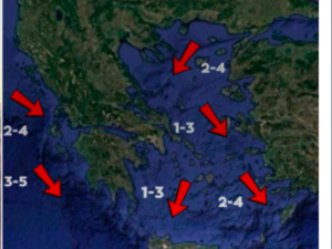
Unseasonably warm temperatures are expected in the coming days, with enhanced southerly winds carrying African dust from midweek mainly to the southernmost parts of Greece, according to Thodoros Kolydas.
“Maintaining very high temperatures will be the main feature of the week ahead. Otherwise, very strong southerly winds will carry dust from the coast of Africa and will mainly affect the southernmost parts of the country in the middle of the week with weak to moderate concentrations,” the EMY director said in a post.
An overview of the weather on Monday, according to the National Weather Service
In the west, a few clouds in the west, increasing in places, with a chance of light local rain mainly in the Ionian Sea. In the rest of the country, generally clear weather, with a few occasional clouds in the morning in the eastern Aegean and thin clouds from the afternoon in the central and northern regions. Visibility will be locally limited early in the morning in the eastern Aegean and in the evening hours on the mainland.
Winds will blow from southerly directions up to 3 to 4 Beaufort, in the sea locally 5 and from the afternoon up to 6 Beaufort. The temperature, at high levels for the season, will reach 18 to 21 degrees Celsius and locally in the mainland 22 degrees Celsius.
Forecast for Tuesday (11/3)
In the west thin clouds that will quickly thicken and in the midday and afternoon hours there will be local rain and in the northwest isolated thunderstorms. In the remaining areas thin clouds at times thicker with local showers from the afternoon in the northern mainland.
In the morning and evening hours visibility will be locally limited. African dust is favoured mainly in the west and south.
Winds will blow from southern directions 4 to 6 and in the sea locally 7 Beaufort. The temperature will remain high for the season and will reach 19 to 21 and locally in Crete 22 to 23 degrees Celsius.
Ask me anything
Explore related questions


