The winter scene with chilly cold and snow in northern Greece seems to be gradually receding and, according to meteorologists, will give way to unseasonably high temperatures.
“The phenomena are gradually receding, while from Saturday the temperature will return to normal levels both in terms of minimum and maximum values. During Holy Week, a warm transfer of air masses from the coast of Africa is predicted and this will result in temperatures ranging at high values for the season,” according to Thodoris Kolydas.
Marousakis: Spring will knock on our door again
“Winter weather for a few more 24 hours as from Holy Week Spring will gain more and more ground day by day,” says Klearhos Marousakis in a post.
According to OPEN’s meteorologist, “the latest forecasts call for a mild weather during Holy Week and the days of Easter. Great Saturday and Easter Sunday, if there will be some instability phenomena will be in the afternoon hours and as a rule in mountainous areas of the mainland. So spring will knock on our door again and it is falling at the most appropriate point.”
Meteorologist George Tsatrafillas also points to the arrival of heat, with the news about the weather for Holy Week being pleasant.
“As far as the evolution of the weather is concerned, the news for the weather of Holy Week is pleasant!Specifically, from Palm Sunday, the transfer of warm air masses from the coast of Africa to our country begins (this time), resulting in the mercury to be 6 to 8 degrees above the normal for the season levels. Rains are not predicted,” he says. From Great Wednesday onwards, the thermometers will exceed 25-26 degrees.
Below -9 °C minimum temperature yesterday in Shelley
Frost was recorded in areas of Macedonia and Thrace as well as in high altitude areas of the rest of the country. The table below shows the 8 stations of the meteo.gr / National Observatory of Athens network that recorded the lowest minima on Wednesday morning 09/04. As shown in it, the temperature in Seli dropped to -9.2 °C, followed by Vlasti Kozani (-6.0 °C) and the shelter of Dragati Rodopi (-4.7 °C).
Today’s weather
Initially, thin clouds are expected, which will be thicker in places at times. A few, sporadic and occasional showers are expected, on the mainland from midday. Visibility will be locally limited on the mainland until the morning and towards the end of the day.
The temperature in Western Macedonia will range from -1 to 15 degrees Celsius, in the rest of Macedonia and Thrace from 1 to 18, in Thessaly from 3 to 20, in Epirus from 0 to 16, in Sterea from 1 to 17, in the Peloponnese from 0 to 18, in the Ionian Islands from 3 to 16, in the North and East Aegean Islands from 2 to 16, in the Cyclades from 4 to 16, in the Dodecanese from 9 to 17 and in Crete from 6 to 19 degrees Celsius.
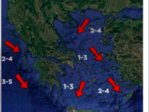
Winds in the North Aegean will blow from southwest to west directions from 3 to 5 Beaufort. In the Dodecanese the winds will initially blow from northwestern directions 4 to 6 Beaufort but from midday they will become westerly 3 to 5 Beaufort. In the rest of the South Aegean and Central Aegean, winds will blow from westerly directions from 2 to 4 Beaufort and from noon onwards 4 to 6 Beaufort. In the Ionian Sea the winds will blow from the northwest from 2 to 4 Beaufort and from the afternoon from 3 to 5 Beaufort.
In Attica sunshine is expected with occasional and sparse clouds. Winds will blow from westerly directions from 2 to 4 Beaufort and from the morning 3 to 5 Beaufort. The temperature in the center of Athens will range from 8 to 17 degrees Celsius.
In the prefecture of Thessaloniki clouds are expected with a small chance of occasional and local rain in the afternoon and afternoon. Winds will blow from northwest directions up to 3 Beaufort and in the afternoon 2 to 4 Beaufort. The temperature in the center of Thessaloniki will range from 8 to 16 degrees Celsius.
The weather on Friday (11/04)
In Thrace, the islands of the eastern Aegean, Crete, the Cyclades and the Dodecanese cloudy with local rain and possibly isolated thunderstorms and a quick improvement. In the rest of the country a few clouds, partly cloudy, mainly in the midday and afternoon hours. Some snow will fall in the northern mountains.
Winds will blow north northwest 4 to 6 and in the northern Aegean Sea partly in the morning 7 Beaufort. From the afternoon in the northern Aegean they will turn to southwestern 3 to 5 Beaufort.
The temperature will rise slightly in the west. It will reach 12 to 14 degrees in the northeast, 16 to 18 and locally 19 degrees in the west and 15 to 17 degrees Celsius in the rest of the regions. In the early morning frost will occur in places on the northern continent.
The weather on Saturday (12/04)
A few clouds, partly cloudy, mainly in the midday and afternoon hours, when local rain or rain will occur in the mainland and Crete.
Winds will blow from the north 3 to 5 and in the sea locally 6 Beaufort.
The temperature will rise throughout the country and will reach 20 degrees Celsius in places in the Ionian Sea and the southern mainland.
The weather on Sunday (13/04)
In the eastern mainland, Crete and in the noon and afternoon hours in the rest of the continent, partly cloudy with local rain or rain. In the rest of the country a few clouds.
Winds will blow north northeast 3 to 5 and in the Aegean Sea locally 6 Beaufort.
The temperature will not change significantly.
Ask me anything
Explore related questions


