×
GreekEnglish

×
  • Politics
  • Diaspora
  • World
  • Lifestyle
  • Travel
  • Culture
  • Sports
  • Cooking
Friday
19
Dec 2025
weather symbol
Athens 16°C
  • Home
  • Politics
  • Economy
  • World
  • Diaspora
  • Lifestyle
  • Travel
  • Culture
  • Sports
  • Mediterranean Cooking
  • Weather
Contact follow Protothema:
Powered by Cloudevo
> Politics

After Greece, Turkey also presented a map for maritime spatial planning – They are splitting the Aegean in two

‘Blue Homeland’ deepens, says Milliyet – The map was not published in the Turkish media until after the Greek announcement – According to the newspaper, Turkey chooses the median line of the Aegean as a border, claiming one side of the sea

Newsroom April 16 01:40

Ankara reportedly intends to draft its own maritime spatial planning map for the “Blue Homeland,” aiming to solidify its claims in the Aegean and the Eastern Mediterranean.

Turkey had previously threatened to draw up its own maritime spatial plan in response to the European Commission’s publication of a working map regarding Greece‘s maritime spatial planning. According to a report by the newspaper Milliyet, Turkey is opting for the median line of the Aegean as a border, claiming one side of the sea.

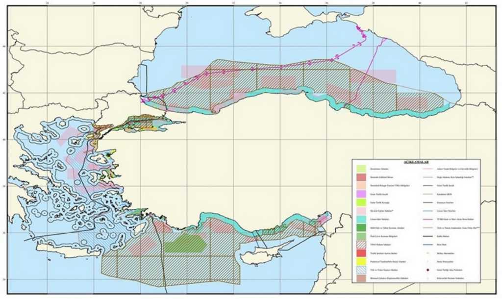
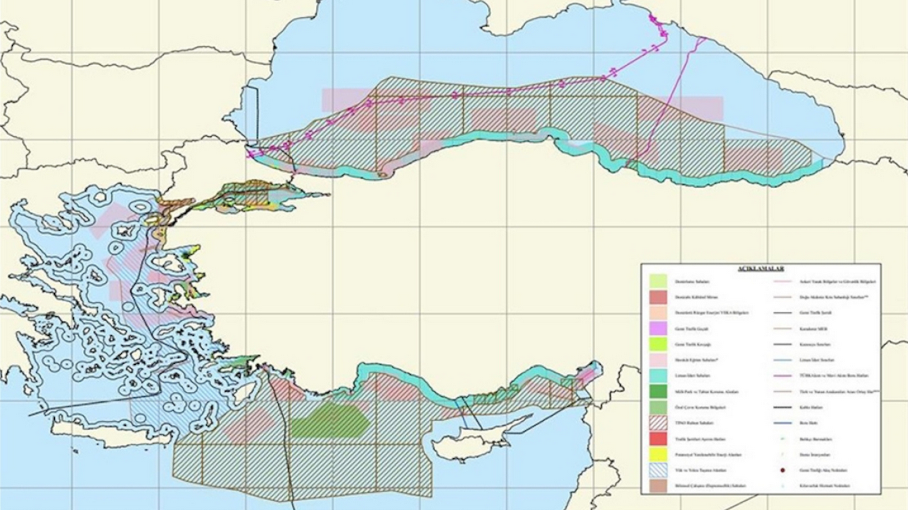
This reflects Turkey’s longstanding position that islands are not entitled to maritime zones and, therefore, the delimitation of the continental shelf and Exclusive Economic Zone (EEZ) should be based on the median line between the mainland coasts of Greece and Turkey. In fact, according to the report, a “scientific” map has been drawn up depicting the “borders” of Greece and Turkey in the Aegean, based on the median line between the mainland coasts.

It is noted that this map had not been circulated in the Turkish media, and even Milliyet did not include it in its article, despite referencing it. However, after Greece’s announcement of its Maritime Spatial Planning Map, the article was updated and the map was included.

>Related articles

Code “Maritime Arc”: The US plan that is redrawing the map of Greece from North to South

Symbolic roadblocks and blockades in Imathia, Pella, Pieria, and Kavala: which roads are closing and when

Case of bacterial meningitis in a 17-year-old student in Chania after a school trip to the Czech Republic

Nevertheless, Turkish media emphasize that the map does not represent the official position of the Turkish state but rather a scientific and legal interpretation.

The next step involves drafting a corresponding plan for the occupied areas in Cyprus. The map shows an interruption of the notional maritime connection between Crete and Cyprus, precisely where the planned electricity interconnection cable is expected to be installed.

This move by Turkey, however, is unilateral and unrelated to the process of determining the Maritime Spatial Plans of EU member states.

Ask me anything

Explore related questions

#aegean sea#challenge#cyprus#diplomacy#EEZ#greece#Maritime Spatial Planning#maritime zones#politics#provocation#turkey
> More Politics

Follow en.protothema.gr on Google News and be the first to know all the news

See all the latest News from Greece and the World, the moment they happen, at en.protothema.gr

> Latest Stories

Code “Maritime Arc”: The US plan that is redrawing the map of Greece from North to South

December 19, 2025

Symbolic roadblocks and blockades in Imathia, Pella, Pieria, and Kavala: which roads are closing and when

December 19, 2025

Case of bacterial meningitis in a 17-year-old student in Chania after a school trip to the Czech Republic

December 19, 2025

Enhanced metro services on Sundays, December 21 and 28

December 19, 2025

Who is Commander Ioannis Kizanis, the captain of the frigate HS Kimon

December 19, 2025

Provocative stance by Pappas over the assault on a journalist: “I raised my hand, but he has no mark. I said, ‘Look at me and look at him’”

December 19, 2025

Our bright side with the Belharra and the downside with the roadblocks, Milena the “faux Zoitsa” of the Parliamentary Inquiry, the double deal in Insurance, the 15,000 properties

December 19, 2025

Christmas with rain, New Year with cold predicted by Marousakis

December 19, 2025
All News

> Greece

Symbolic roadblocks and blockades in Imathia, Pella, Pieria, and Kavala: which roads are closing and when

Producers are remaining at their agricultural and livestock blockades and are proceeding with mild-form actions, stating that they do not intend to inconvenience citizens, especially ahead of the holiday season

December 19, 2025

Case of bacterial meningitis in a 17-year-old student in Chania after a school trip to the Czech Republic

December 19, 2025

Enhanced metro services on Sundays, December 21 and 28

December 19, 2025

Who is Commander Ioannis Kizanis, the captain of the frigate HS Kimon

December 19, 2025

Christmas with rain, New Year with cold predicted by Marousakis

December 19, 2025
Homepage
PERSONAL DATA PROTECTION POLICY COOKIES POLICY TERM OF USE
Powered by Cloudevo
Copyright © 2025 Πρώτο Θέμα