The Aspirations of Albanian Irredentism as Reflected in Official Cartography
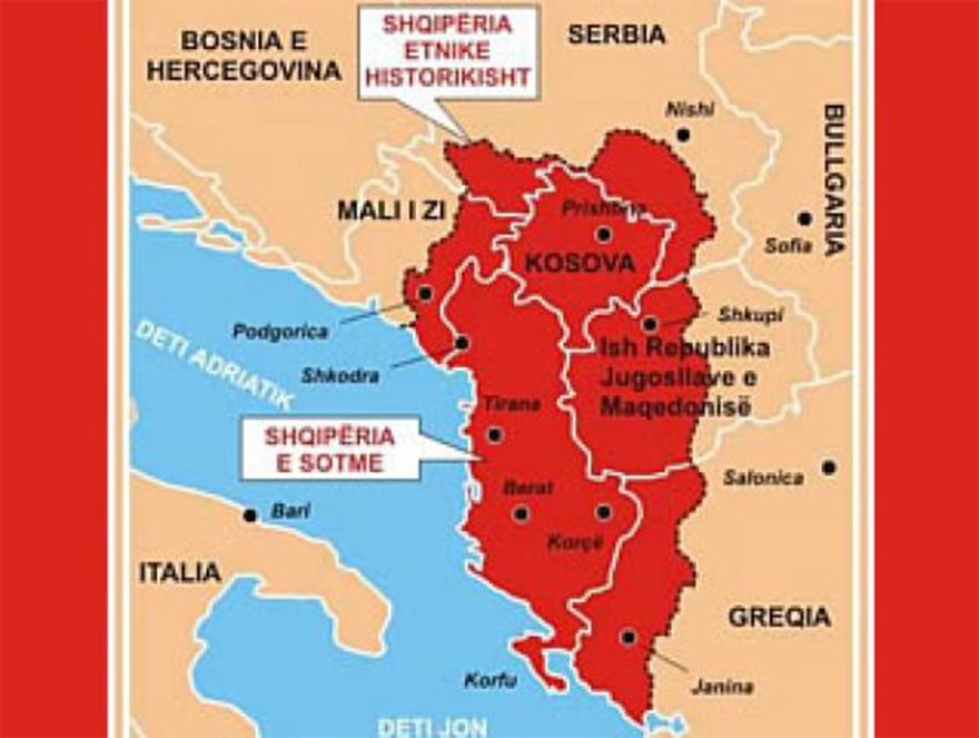
The idea of a “Great Albania” remains a longstanding national aspiration among our northern neighbors. Over the decades, a series of maps—some originating from nationalist circles and others from official state sources—have circulated, depicting territorial claims that extend into Greek Epirus, including Preveza and Filippiada, as well as regions of Western Macedonia such as Kastoria and Florina. While maps from nationalist groups may be dismissed as mere propaganda, their significance escalates dramatically when these cartographic representations are issued by the Albanian state itself.

Historical Context and Significance
The territorial ambitions of Albania have been vividly illustrated through maps dating back to the early 20th century. The most notable examples include:
- The 1941 map during Italy’s occupation of Albania, which explicitly depicted a Greater Albania encompassing Greek regions.
- The 1960 document submitted to NATO by the Italian General Staff, which contained a map claiming territories in Epirus and Western Macedonia.
- The 1981 map circulated among the United Nations, American universities, and diplomatic missions, portraying an expanded Albanian territory that includes significant Greek regions.
These maps are not mere illustrations but serve as political tools, encapsulating irredentist ideology and territorial claims that persist into contemporary geopolitics.
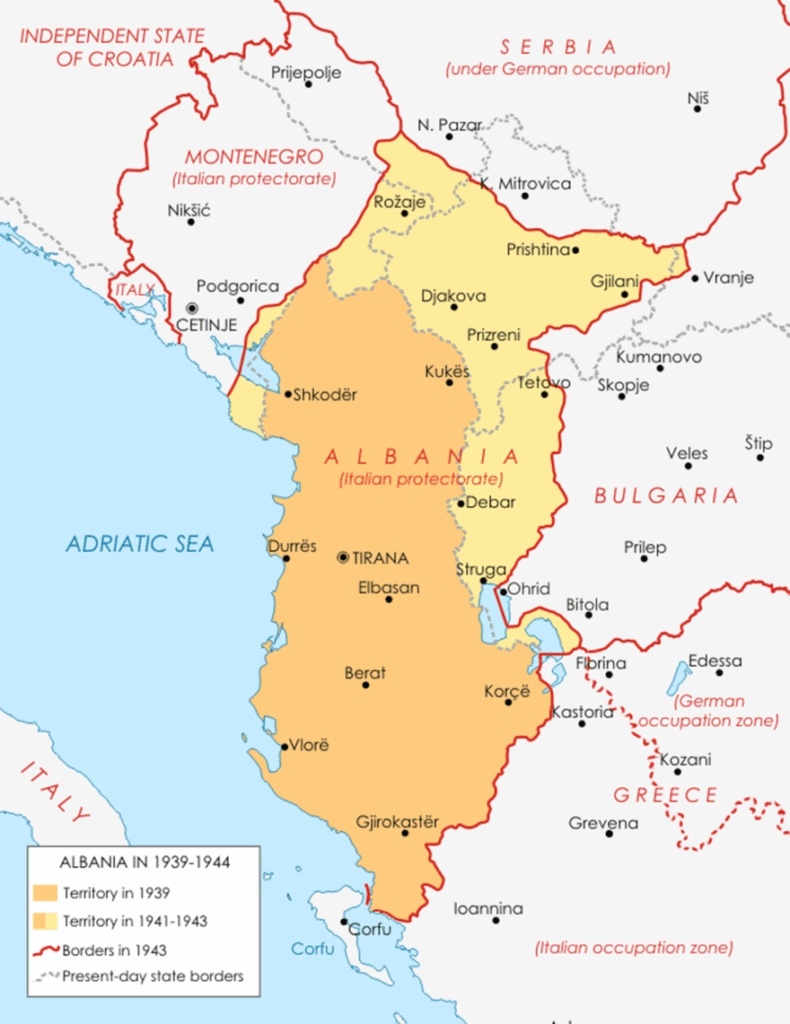
The Map of 1941: During Italian Occupation and the “Partition of Epirus”
Although the Greek-Albanian border was formally established by the Protocol of Florence on December 17, 1913, the actual demarcation in the field remained unresolved. The 1913 protocol was largely theoretical; the real in loco border delineation was left to the 1923-1925 negotiations, which were fraught with tensions and external influences.
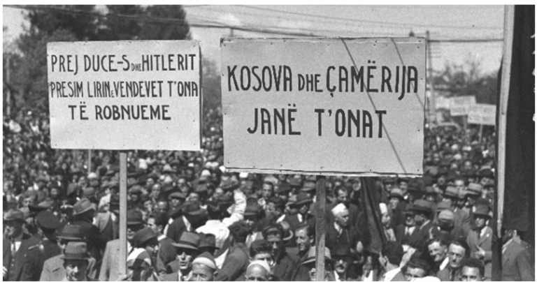
In 1941, during the Italian occupation of Albania, the Albanian Prime Minister Shefqet Vërlaci publicly advanced territorial claims through official maps, claiming parts of Greece—particularly Epirus—as part of a Greater Albania. These claims were openly propagated via maps distributed during diplomatic visits, notably during Vërlaci’s visit to Rome in May 1941, where he presented cartographic material asserting Albanian sovereignty over regions such as Thesprotia, Ioannina, Preveza, and parts of Western Macedonia.
While these claims were largely discredited post-World War II, their existence underscores the expansionist aspirations embedded within Albanian nationalist discourse.
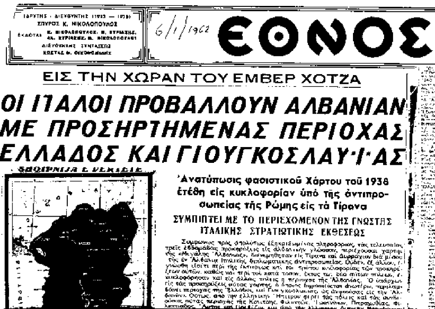
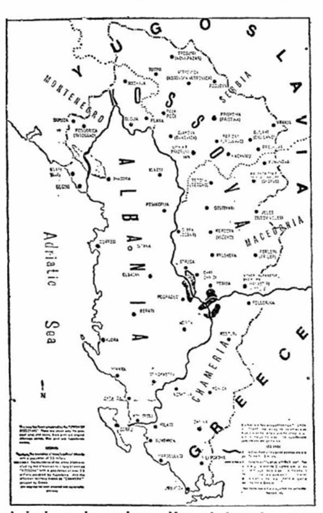
The 1960 Map: NATO and the Italian General Staff Document
Moving forward to May 1960, an important document emerged from the Italian General Staff, which was circulated among NATO military authorities. This document included a map claiming Albanian sovereignty over territories in Greece, specifically in Epirus and parts of Western Macedonia. The map depicted the following regions as part of a Greater Albanian entity:
- The cities of Konitsa, Filiates, Ioannina, Paramythia, and Preveza.
- The areas of Florina and Kastoria in Western Macedonia.
This document explicitly stated that these regions, which were historically Greek, were “belonging to Albanian territory,” asserting a territorial claim based on ethnolinguistic considerations. The map and the accompanying text ignited significant controversy within Greece. The Greek government responded with protests, demanding the removal of such provocative cartography from NATO channels.
Remarkably, after intense diplomatic pressure, this “offensive” document was withdrawn from NATO’s official publications, illustrating the sensitivity surrounding territorial disputes and the impact of international diplomacy.
The 1981 Map: Circulated in the United States and International Institutions
Despite diplomatic efforts, Albanian irredentist propaganda persisted into the 1980s. The most recent significant example is a 1981 map circulated among U.S. diplomatic missions, the United Nations, and academic institutions in Washington, D.C. This map depicted a significant territorial expansion of Albania, which included:
- The entire region from Preveza to Florina.
- The cities of Ioannina, Himara, Konitsa, and other parts of Greek Epirus.
- The region was labeled as “Albanian Chameria,” implying that these territories are historically Albanian and should be part of Albania.
This map was published in an article by Giorgos Karayiannis in the newspaper “Kathimerini” on June 3, 1981, highlighting its propagandistic nature and its role in promoting Albanian expansionist ambitions. The map was designed and disseminated by organizations associated with the Albanian diaspora and was printed in the Albanian magazine “E Lirë,” published in Tirana with government approval.
The 1981 map’s circulation coincided with increased activity by Albanian organizations representing the Greek minority in Northern Epirus, which aimed to garner international support for territorial claims.
The Geopolitical and Cultural Implications
These cartographic representations are more than mere artifacts; they reflect a persistent irredentist ideology rooted in Albanian nationalism. The maps serve as symbolic tools, reinforcing claims to territories inhabited by ethnic Greeks, particularly in Epirus and Western Macedonia.
The circulation of these maps among diplomatic, academic, and international institutions underscores the strategic importance that Albania attributes to territor
ial revisionism. The continued propagation of such claims fuels tensions in the region and complicates efforts toward peaceful resolution of border disputes.
Official Reactions and Current Status
Greek authorities have consistently condemned these maps and the claims they represent. Diplomatic protests have been lodged whenever such cartographic material appears in international forums. Despite this, the persistent circulation of these maps demonstrates that irredentist sentiments remain influential among certain political and nationalist circles within Albania.
The historical and ongoing circulation of official maps asserting Albanian territorial claims over Greek regions reveals a complex dimension of Balkan geopolitics. These maps are not just cartographic exercises but are emblematic of a broader irredentist ideology that seeks to reshape borders based on ethnolinguistic and nationalistic considerations. Understanding this history is crucial for fostering regional stability and promoting dialogue grounded in international law and respect for sovereignty.
Ask me anything
Explore related questions