
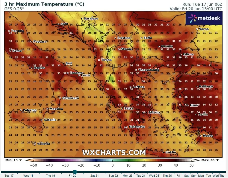
Meteorologist Klearchos Marousakis warns that Greece is about to enter a period of intense heat over the coming days. Temperatures will rise significantly, peaking at around 38°C, especially in Thessaly and other inland areas. This heatwave is already impacting much of the country and is expected to reach its maximum intensity by Friday, raising the discomfort index ,particularly in urban centers.
However, this extreme heat will be relatively short-lived. From midday Friday, a sharp weather shift is anticipated with thunderstorms, localized showers, and a noticeable drop in temperatures, especially across the mainland. These changes will be driven by the arrival of a cold upper-atmosphere lake, triggering intense weather phenomena expected to last approximately 48 hours until Sunday.
The storm activity will primarily affect central, eastern, and northern Greece, with a heightened risk of hail and severe electrical storms. Thessaly, in particular, should be on high alert for potentially dangerous conditions.
Meteorologists urge the public to closely monitor weather updates due to the rapid and intense nature of the forecasted changes.

Additional Weather Highlights
Fire Risk: Today, a high fire danger (Category 3) is forecasted for 11 regions, including Attica, Kythera, Argolida, Boeotia, Evia, Corinthia, Laconia, the Cyclades, and parts of the northeastern Aegean islands such as Lesvos and Chios.
Today’s Weather: Generally clear skies with cloud buildup and local thunderstorms expected in mountainous areas, especially along the Pindos range. Temperatures range from 13°C to 36°C, depending on the region.
Thursday, June 19: Mostly clear with some afternoon clouds and isolated mountain showers. Winds will strengthen, especially in the east and Aegean, with temperatures stable around 33-35°C on the mainland.
Friday, June 20: Clear morning followed by midday cloud development with local rain and thunderstorms mainly in the mountains and northern areas. Winds are variable, with temperatures holding steady.
Saturday & Sunday, June 21-22: Cloudy periods with local showers and thunderstorms, especially in northern and central regions. Temperatures will gradually decrease, with stronger winds in the Aegean reaching up to 7-8 Beaufort by Sunday.Stay alert and prepared as this dynamic weather pattern unfolds.
Ask me anything
Explore related questions


