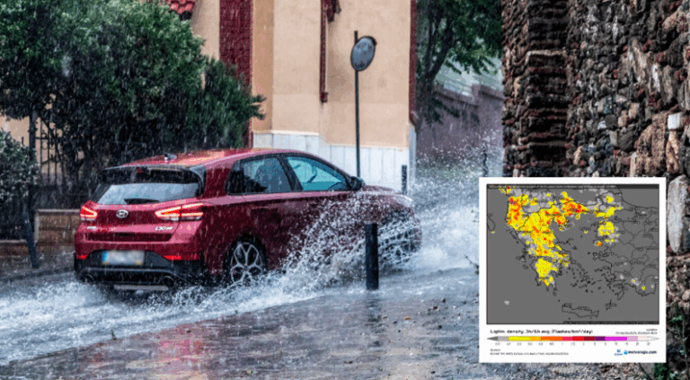
A change in the weather is forecast from midday in northern Greece with localized strong thunderstorms accompanied by strong winds (burrinia) at times. For the 48-hour bad weather that will hit parts of the country, the National Weather Service (NWS) issued an emergency weather deterioration report yesterday.
As stated:
A change in the weather in our country is forecast from noon on Friday (20-6-2025) in northern Greece and on Saturday (21-6-2025) and in southern regions with strong thunderstorms in some places, which will be accompanied by strong winds at times.
In detail, heavy showers and thunderstorms will occur:
A. In Macedonia from Friday noon until Saturday morning, with the exception of central Macedonia (mainly Halkidiki) where strong phenomena will continue until Saturday noon.
Β. In the Sporades on Saturday from early morning until early afternoon.
Γ. In Sterea and the Peloponnese on Saturday from mid-morning until early evening.
D. In Epirus in the evening hours on Saturday.
https://twitter.com/i/status/1935664834365755599
From Sunday, the weather is expected to improve, with the rains stopping, but the north wind is expected to increase, and the temperature will drop.
As Thodoros Kolydas reports, temperatures through Friday will be at most 34 to 36 on the mainland, while Friday and Saturday showers will hit in the afternoon.
🎯 Η ΠΡΟΟΠΤΙΚΗ ΤΟΥ ΚΑΙΡΟΥ
✅Θερμοκρασίες εως την Παρασκευή το πολύ 34 με 36 στα ηπειρωτικά και άστατος καιρός την Παρασκευή και το Σάββατο στα ηπειρωτικά με μπόρες η καταιγίδες κυρίως το μεσημέρι και το απόγευμα. To ΣΚ πέφτει η θερμοκρασία κατά 3 με 5 βαθμούς και επανέρχεται σε… pic.twitter.com/ilBtBKaZbc— Theodoros Kolydas (@KolydasT) June 18, 2025
The areas of highest electrical activity on Friday and the areas of hail by Saturday morning. Although rainfall totals will not be particularly high, high rainfall is predicted locally
After 38 dangerous thunderstorms with lightning and hail
For his part, Giorgos Tsatrafillias says in a post that after the 38-degree dangerous storms with thunder and hail are coming…”
HΛΕΚΤΡΙΚΗ ΔΡΑΣΤΗΡΙΟΤΗΤΑ (ΚΕΡΑΥΝΟΙ) ΚΑΙ ΧΑΛΑΖΙ
Οι περιοχές με την μεγαλύτερη ηλεκτρική δραστηριότητα την Παρασκευή και οι περιοχές χαλαζοπτώσεων έως το πρωί του Σαββάτου. Παρότι τα ύψη βροχής δεν θα είναι ιδιαίτερα υψηλά , προβλέπεται μεγάλη ραγδαιότητα σε τοπικό επίπεδο. #έκτακτο… pic.twitter.com/qoxubusuD0— Theodoros Kolydas (@KolydasT) June 19, 2025
“The heat wave peaks today Friday with thermometers reaching 37-38 degrees in the Thessaly plain and 35 to 36 degrees in several continental areas (in Attica-Thessaloniki), Crete and the Dodecanese,” according to Alpha’s meteorologist, who stresses that “the cold air in the upper atmosphere in combination with the warm air in the lower, will create ideal conditions for strong instability in the weekend Friday – Saturday in the mainland, with thunderstorms during the warm hours of the day which are not excluded to be accompanied by hail and lightning“.
“Especially on Saturday from the morning in Chalkidiki, Magnesia, Sporades, northern Evia, and gradually in Sterea (and Attica ) , Epirus, Ionian, and Peloponnese. The storms will potentially be dangerous from the intense lightning activity, and I say this mainly not only for causing forest fires, but also for bathers and people in the countryside. That is why we are exercising the necessary caution. Temperatures between Saturday and Tuesday will drop 4-5 degrees. Then I do not rule out that we will have the first fire episode of the summer!“, he concludes.
Marousakis warns of storms – express storms – The 6 dangerous areas
The approaching “cold lake” is expected to cause dangerous weather, with six areas on a high level of warning, Clearchos Marousakis warns.
“Our forecast system puts Macedonia, Epirus, Thessaly, the western and northern Aegean, and much of the Peloponnese at very high risk. When this disturbance completes its action near Sunday, a large pressure differential will develop towards the Aegean, and the northerly winds will strengthen to storm levels. This will cool us down quite a bit, but will significantly increase the risk of fire!“, says the OPEN meteorologist.
In a new post, he provides video maps showing the atmospheric systems that are expected to be of concern over the next five days.
“On one side, we have the key player, ‘atmospheric mountain’ with the letter ‘Y, ‘ whose position determines the arrangement of the others. With the letter “X” in southern Italy, the detached cold air mass will show a tendency to move eastwards towards our region. With the blue curve and the letter “X” to the north of our country the cold front which will move southwards, entraining the cut-off cold air mass from the Italian region and finally with the letter “X” a new disturbance in the middle troposphere from the northwestern Balkans that will form on the eastern rim of the atmospheric mountain trying to spread further east to bring us much warmer air masses from Africa. Whether it will succeed, when, and to what extent we will see in the coming days,” he explains in his post.
High fire danger today in 10 areas of the country
High fire risk (risk category 3) is forecast for today, Friday, June 20, in ten areas of the country, according to the Fire Risk Forecast Map issued by the General Secretariat of Civil Protection of the Ministry of Climate Crisis & Civil Protection.
The following areas will be on “yellow” alert today:
“Emergency alert” is now in the “yellow alert” zone in Messinia,
Laconia,
Mytilene,
Chios, Psara, Samos, Ikaria,
Rhodes, Karpathos, and Kasos.
The temperature exceeded 37 °C yesterday in the Peloponnese
Temperatures exceeding 36 °C were recorded on the mainland on Thursday, 19/06/2024, with the highest maximum temperature recorded in Argos and the Patras refugee camps at 37.1 °C.
According to the network of automatic weather stations of the National Observatory of Athens / meteo.gr, the eight highest maximum temperatures during the midday hours of Thursday 19/06 are presented in the following Table.
Today’s weather
Sunshine is forecast with a few clouds, increasing on the mainland during the warmer hours of the day, with local showers or isolated thunderstorms mainly in the mountainous mainland and possibly on the islands of the North Aegean. The phenomena will gradually stop, with the exception of Eastern Thessaly (Magnesia), Central Macedonia (Halkidiki) and the North Aegean, which will continue locally during the evening hours.
The temperature will range from 22 to 37 degrees in Northern Greece (in Western Macedonia from 16 to 30 degrees), 20 to 36 degrees in Central and Southern Greece (in Thessaly locally up to 37 degrees), 19 to 34 degrees in Western Greece, 23 to 33 degrees in the Cyclades and Crete, 21 to 36 degrees in the East Aegean islands and 23 to 31 degrees in the Dodecanese.
Winds will blow in the Aegean from northerly directions from light to almost moderate 3-4 Beaufort and in the Southeastern Aegean from northwestern directions moderate 5 Beaufort, while in the Ionian Sea from northwestern directions light and occasionally almost moderate 4 Beaufort.
Sunshine with a few clouds, increased during the warm hours of the day, with the possibility of occasional rain in the northern and mountainous parts of the prefecture, we expect on Friday in Attica. The temperature will range from 26 to 36 degrees Celsius, but in the north and coastal areas it will be 2-3 degrees lower. Winds will blow from variable directions, light.
We expect sunshine with a few clouds, increasing in the afternoon and evening hours of the day on Friday in Thessaloniki. The temperature at high levels will range from 25 to 36 degrees Celsius. The winds in Thermaikos will blow from variable directions, light, which in the evening hours will occasionally shift to northwestern moderate 4-5 Beaufort.
The weather on Saturday, June 21
In central Macedonia, the Sporades, eastern Thessaly, Evia, from midday in Central Macedonia, the Peloponnese and Sterea, and in the afternoon in Epirus, showers and occasional thunderstorms. The phenomena will be locally strong in central Macedonia (mainly in Halkidiki) until noon, in the Sporades until early afternoon, in Sterea and Peloponnese until early evening, and in Epirus in the afternoon. In the rest of the regions, generally clear weather with occasional clouds in the midday-afternoon hours on the mainland and in Crete, where local rain is likely to occur in the mountains. Visibility in the west in the early morning will be locally limited.
Winds will blow from northerly directions in the west 3 to 5, in the east 4 to 5, and in the Aegean Sea 6 to 7 Beaufort.
From the south, the sea will be windy, with winds in the north and south-eastern parts of the island and sea breezes in the south-eastern part of the country.
The temperature will drop by 3 to 5 degrees from its maximum values and will not exceed 30 to 32 degrees Celsius.
The weather on Sunday, June 22
In central Macedonia a few clouds, partly cloudy with local showers or rain, mainly in the midday-afternoon hours. In the rest of the country, generally clear weather and only in places on the mainland in the midday-afternoon hours will develop occasional clouds, and in the western mountains, there will be local rainfall.
Winds in the west will blow from eastern directions 3 to 5 and the afternoon west northwest with the same intensity. In the east will blow from the north 4 to 6 Beaufort, and in the Aegean Sea, 7 and locally 8 Beaufort.
The temperature will drop slightly further, mainly in the east.
Ask me anything
Explore related questions


