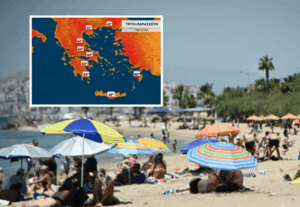
We will get a taste of the heatwave that will come to Greece for good this weekend, as the thermometer will start to rise from Sunday to exceed 40 degrees Celsius in the coming days.
High temperatures during the day and at night will plague almost the entire country from Monday to Friday or even next weekend, forecasters predict.
They say the worst of the heatwave will be from Wednesday onwards, with a possible peak on Friday. Temperatures of 42 degrees Celsius or higher are not unlikely in Athens either.
What meteorologists predict
In his post, Thodoros Kolydas stresses that, with the latest data, “all available forecast data converge in the assessment that a significant heat wave is predicted to hit our country from Tuesday, July 22, with increasing intensity, and to be maintained at least until Friday, July 25, when its peak is predicted.”
The phenomenon will slowly subside and it is possible that we will see very high temperatures next weekend, he added.
As for the maximum values, from Wednesday onwards we will see temperatures reaching and exceeding 42 degrees on the mainland, but also in Athens.
For his part, Clearchos Marousakis says that “between Monday and Friday we will experience an organized and extensive spatial and temporal heat wave, the characteristics of which will be
1. Extended very high maximum temperatures with values of more than 37° Celsius in most areas
2. The high minimum temperatures with an emphasis on urbanized areas where mercury will be found even above 30° Celsius for many hours even in the dead of night.
3. High relative humidity levels are expected in marine coastal areas through the night so discomfort will be high.
4. The heat wave we expect will also be combined with windy conditions in the Aegean Sea in particular. This implies an increase in the risk of fire.
5. The “ceiling” in terms of maximum temperatures from the point of view of atmospheric circulation is estimated at 41° to 43° Celsius and, as a rule, in enclosed areas far from the sea. Local factors having to do with the interaction of topography with wind and solar radiation are likely to push the mercury higher, but this will be an isolated event and should not be put at the top of the information on the heatwave issue.
6. The exit from this long lasting heat wave is timed to occur over the coming weekend and is likely to be “violent” in terms of changing air circulation“.
A new warm spell starts on Sunday, as meteorologist Panagiotis Giannopoulos warns.
Saturday is expected to be the mildest day, with temperatures around 35°C. From Sunday, however, the temperature will rise again. The new heat wave will peak from Tuesday to Friday, with maximum temperatures on the mainland topping 40 degrees and in Athens reaching 41°C, where we can talk about heatwave conditions.
Temperatures are expected to start to recede next Saturday, based on the latest forecast data. In the Aegean Sea, winds will continue to blow steadily at 5-6 Beaufort, creating more bearable conditions in island areas.
The next few days will require caution as the duration of the heat wave will be its main feature.
Giannis Kallianos predicts a six-day heatwave, from Monday to Saturday with temperatures of 37-40 degrees Celsius on the islands, the highest temperatures will be in Rhodes, Lesvos, Chios and 41-43 degrees Celsius on the mainland.
Locally in Thessaly, Eastern Sterea and Eastern Peloponnese, the temperature will reach 44 degrees Celsius.
The meteorologist also presented the temperatures in Athens in the coming days, stressing that at midnight temperatures will range between 34 and 35 degrees and in the city center the mercury will not fall below 32 to 33 degrees Celsius.
Details:
Saturday, July 19: 36 degrees Celsius
Sunday July 20: 38 degrees Celsius
Monday July 21: 40 degrees Celsius
Tuesday 22 July: 41 degrees Celsius
Wednesday, July 23: 42 degrees Celsius
Thursday 24 July: 42 degrees Celsius
Friday 25 July: 40 degrees Celsius
The Giorgos Tsatrafyllias predicts seven days with temperatures above 40 degrees. “In some cases the heatwave will be extreme with temperatures above 44 degrees, we may see 45,” according to the meteorologist.
“In urban centers for five to six days the temperature will not fall below 33 degrees during the day,” according to the meteorologist.
George Tsatrafyllias said that in four areas the heat wave behavior to be extreme with 44-45 degrees. Specifically, on Tuesday and Wednesday “we may see 45 degrees in the Thessalian plain such as Larissa, Trikala and Karditsa, 44 degrees in Fthiotida, 45 in Boeotia and 44 degrees in the Argolic plain.” On Wednesday “we will have many 40s. 43 in Athens, 40 in Thessaloniki, 44 in Messinia”.
ERT meteorologist, Anastasia Tyrasky, says that warm air masses moving from Africa through a southwestern current and reaching Greece will cause temperatures to rise from Sunday and on Monday the temperature will reach 40 degrees Celsius. Tuesday, Wednesday, Thursday and Friday “are very warm days that we expect to reach 42 to 43 degrees Celsius.”
Emy forecast for Saturday 19/7
Generally clear weather in most areas, a few clouds in central and eastern Macedonia, Thrace and Thessaly. In the midday and afternoon hours clouds will develop in all eastern continental areas and local rain and possibly in the mountains of Thessaly and central Macedonia isolated thunderstorms will occur.
There may be some thunderstorms and thunderstorms in the south-eastern part of the region.
Winds in the sea will blow west northwest 3 to 5 Beaufort.
The temperature will not change significantly. In the west and the north it will not exceed 33 to 35 degrees, while in the eastern mainland it will reach 34 to 36 degrees, in the East Aegean islands, the Dodecanese and Crete 33 degrees and in the Cyclades 30 to 31 degrees.
Ask me anything
Explore related questions