Rain subsides, winds strengthen, and temperatures rise!
This will be the weather outlook for the upcoming long weekend, which will challenge travelers and put the state emergency mechanism on high alert for wildfires.
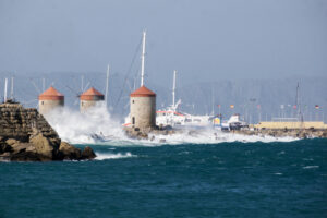
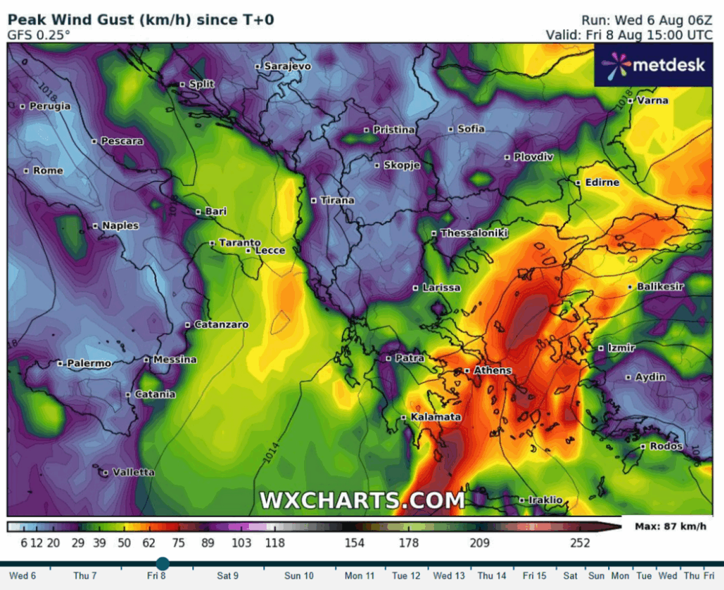
According to meteorologists, especially on Friday, August 8, winds in the Aegean – particularly in the Northern Cyclades – may reach force 9 on the Beaufort scale, potentially resulting in a sailing ban due to the dangerous conditions.
Meteo: “Gale-force northerly winds and worsening fire-weather conditions in the east over the next few days”
According to forecast data from the National Observatory of Athens / Meteo.gr, wind gusts on Thursday, August 7, in Eastern Central Greece may reach 80 km/h, while in Southern Evia, the Cyclades, and Southern Crete, gusts may locally reach 90 km/h.
By Friday, August 8, further intensification is expected, with gusts in Eastern Central Greece, Southern Evia, the Cyclades, and parts of Southern Crete reaching 100 km/h.
Due to this increase in wind strength, fire-weather conditions will worsen significantly in eastern regions, with main concerns being:
Very high potential for wind-driven forest fires with high thermal intensity in eastern and southern areas. Significantly increased difficulty in controlling fires if they break out, especially in areas that haven’t had rainfall recently.
Crisis Meeting by the Ministry for Climate Crisis and Civil Protection
The General Secretary for Civil Protection, Nikos Papaefstathiou, convened the Risk Assessment Committee this morning to assess the impact of the gale-force winds expected to reach 9 Beaufort.
According to committee scientists, northerly winds of 8 Beaufort, with gusts reaching 9, are forecast across Eastern Mainland Greece, the Central and Southern Aegean, and Crete.
Friday will be the most difficult day, with heightened fire risk and potential disruption to maritime travel.
On Saturday, wind strength will reach 7 to 8 Beaufort, while on Sunday, it will remain at around 7 Beaufort in some areas.
Meanwhile, in Western Greece, temperatures will rise steadily, reaching 38 to 39°C, and locally 40°C over the weekend. In eastern regions, due to the north winds, temperatures will stay between 35 and 37°C.
Detailed Forecast – Warning for Strong Winds Up to 9 Beaufort
Northerly winds will be the main weather feature starting from Thursday and continuing into early next week.
In the Aegean, wind strength will reach 7 to 8 Beaufort, and on Friday, may locally reach 9, especially in the Northern Cyclades and Kafireas Strait.
Meanwhile, temperatures will rise gradually, mainly in the western mainland, where they’ll reach 38°C.
Today, Thursday
Macedonia, Thrace, and Crete: Occasional cloudiness, with local showers expected mainly in the afternoon. Rest of Greece: Generally clear, with some local clouds in mainland areas midday to afternoon. Winds: Northerly – Ionian Sea up to 5-6 Beaufort, Aegean Sea up to 7-8 Beaufort. Temperature: Slight increase – 32 to 36°C, locally 37°C inland; up to 30°C in the Cyclades. Attica: Mostly clear. Winds 5-6 Beaufort, eastern parts up to 7 or possibly 8. Temperature 24–34°C. Thessaloniki: Partial clouds, with possible local showers in the afternoon. Winds north-northwest 4-5 Beaufort, temperature 21–32°C.
Friday, August 8
General Outlook: Mostly clear with some temporary clouds in northern Crete, and in Macedonia, Epirus, and Thessaly mountains during midday-afternoon. Winds: Northeast to north – western regions 4–6 Beaufort, eastern regions 6–7, and the Aegean Sea up to 8 Beaufort, with potential 9. Temperature: Little change – Ionian Islands and mainland 35–37°C, other islands 30–33°C, South Crete and Dodecanese up to 34–35°C.
Weekend Weather
Saturday:
Generally clear skies.
Winds: North – west 4–5, Ionian locally 6, east 6–7, Aegean locally 8 Beaufort.
Temperature: No significant change.
Sunday:
Clear skies.
Winds: North – west 3–5, east 6–7, Aegean locally 8 Beaufort.
Temperature: Slight increase.
Monday:
Fair weather.
Winds: North – west 3–4, Ionian briefly 5, east 5–7 Beaufort.
Temperature: Stable.
August Holidaymakers: The Island Getaway Rush Continues – Ships Departing Full
From as early as 6:45 AM, ships departed fully loaded for popular island destinations (Cyclades, Saronic Gulf, Eastern Aegean, Crete).
According to the Ministry of Shipping and Island Policy, 47 ship departures are scheduled from major Attica ports today:
26 from Piraeus
11 from Rafina
8 from Lavrio
It’s noted that during the first weekend of August, ships departed from Piraeus, Rafina, and Lavrio at 100% capacity.
The Coast Guard is on high alert to assist with the increased passenger traffic, even on the roads around the ports.
Ask me anything
Explore related questions