The weather scenery changes this weekend, as rain and thunderstorms will appear in several areas of the country, while locally the phenomena are expected to be intense, according to Sakis Arnaoutoglou. At the same time, next week will bring summer heat again, notes the meteorologist.
Klearchos Marousakis also refers to strong weather phenomena expected to hit the country over the weekend, even though the temperature will rise.
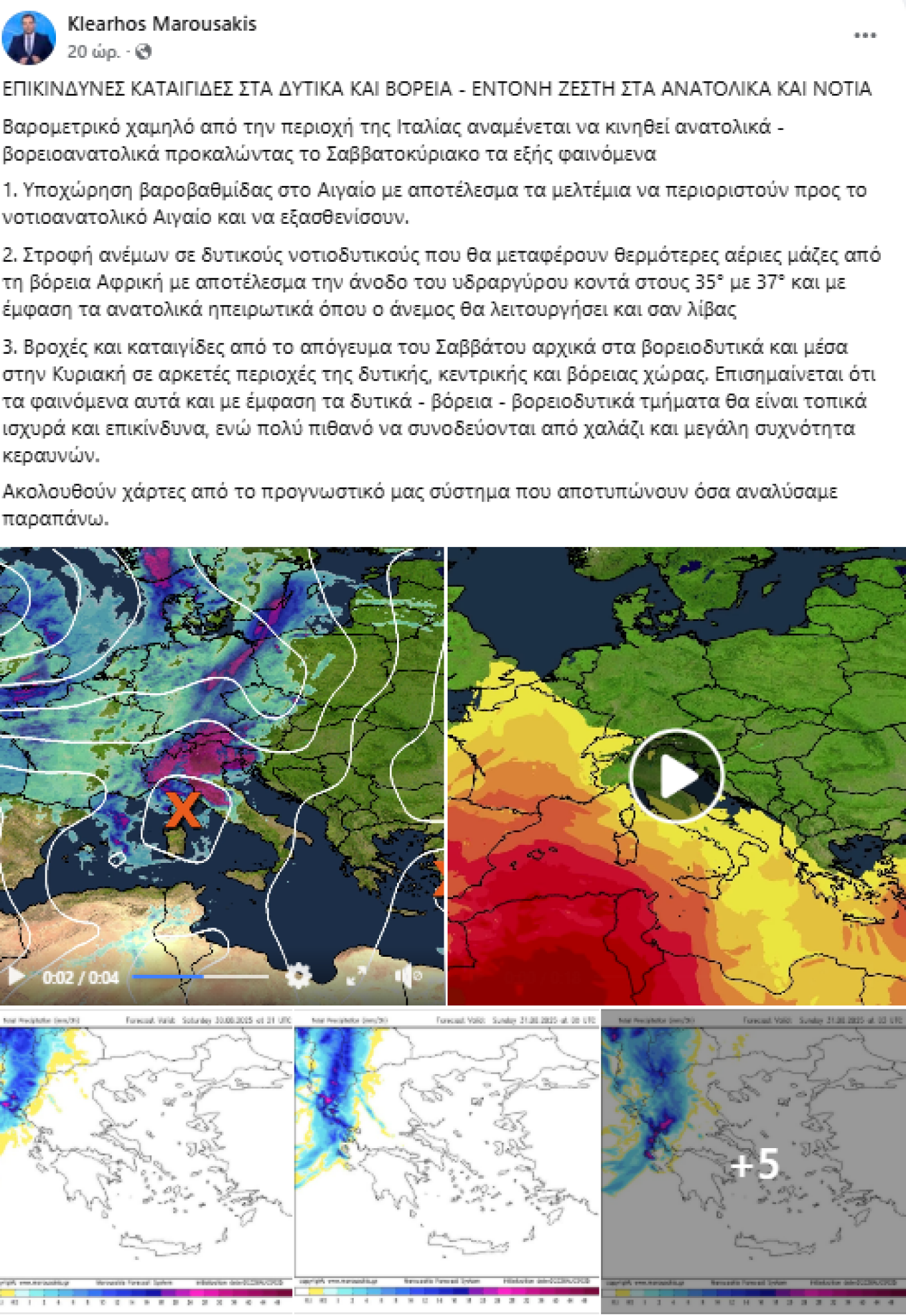
More specifically, the meteorologist from Open explains that a low barometric system from the region of Italy is moving towards our area in the coming days, causing phenomena such as rain, thunderstorms, hailstorms, and intense lightning activity.
At the same time, the winds are carrying warmer air masses from North Africa, resulting in a rise in temperature. In some areas, as he characteristically mentions, the wind will be like a libas (hot dry wind).
As for the meltemia winds, they will be limited to the southeastern Aegean and will weaken.
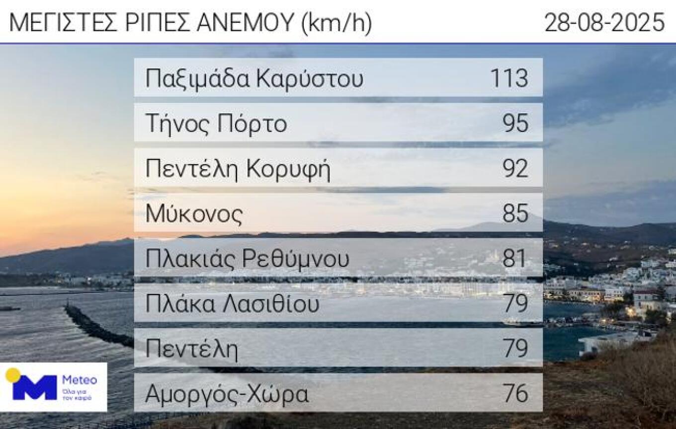
Wind gusts exceeded 100 km/h on Thursday
Very strong northern winds prevailed over the eastern mainland and the Aegean on Thursday, 28/08. According to the network of automatic meteorological stations of meteo.gr / National Observatory of Athens, the strongest gusts up until 17:15 exceeded 90 km/h, while at Cape Paximada they reached 113 km/h. In the relevant table, the 8 stations that recorded the strongest gusts are presented.
The weather today
Across the country, good and warm weather will prevail. During the warm hours of the day, clouds will develop over the mainland, with the possibility of local showers in mountainous areas. Dust concentrations in the atmosphere will be slightly elevated.
Temperatures will range:
- In Western Macedonia: 13 to 29–30°C
- In the rest of Macedonia and Thrace: 15 to 33–35°C
- In Thessaly: 14 to 32–34°C
- In Epirus: 15 to 32–33°C
- In the rest of the mainland: 17 to 32–34°C, locally in the west and south up to 36–37°C
- In the Ionian Islands: 18 to 31–33°C
- In the Aegean islands and Crete: 19 to 28–30°C
- In the eastern Aegean islands: locally up to 33–34°C.
Winds in the Aegean will blow from northern directions at 5–6 Beaufort, gradually shifting to northwesterly with the same intensities. In the Ionian, winds will be variable up to 4 Beaufort.
In Attica and the city of Athens, sunshine is expected. Winds will blow from the north at 4–5 Beaufort but will gradually weaken slightly. The temperature will range from 22 to 32–33°C.
In Thessaloniki, a few clouds are expected, mainly during midday and afternoon hours. Winds will blow mainly from southern directions at 2–3 Beaufort. The temperature will range from 21 to 29–30°C.
The weather on Saturday, August 30
Generally fair weather. From midday in the northern Ionian and gradually in Epirus and western Macedonia, clouds will develop, and rain and scattered thunderstorms will occur.
Winds will blow south to southwest at 3–5 Beaufort, locally in the northern Ionian reaching 6 Beaufort from midday. Only in the Dodecanese will they blow northwesterly at 3–5 Beaufort.
The temperature will not change significantly and will reach 34–36°C in most mainland areas and 30–32°C in the islands.
The weather on Sunday, August 31
In the west and north of the country, clouds will be locally increased with local rain and scattered thunderstorms. The weather will gradually improve: from the morning in the west, from early afternoon in Macedonia, and from the evening in Thrace. In the rest of the country, generally fair weather with a few local clouds in Thessaly.
Winds will blow south to southwest at 3–5 Beaufort, and from midday in the west, northwest at 4–5 Beaufort.
The temperature will drop in the west and north.
Ask me anything
Explore related questions