Unstable weather conditions are expected across Greece over the next 48 hours due to a low-pressure system approaching the country from the northwest. Its cold front will move eastward, crossing Greece by midday on Tuesday, October 7.
According to the latest forecast data from meteo.gr / National Observatory of Athens, the main features of the upcoming weather system will be:
Heavy rain and thunderstorms in several areas until Tuesday noon, October 7
Strong winds, reaching 6–7 Beaufort in parts of the seas on Monday (October 6) and Tuesday (October 7)
A noticeable drop in temperature on Tuesday compared to Monday
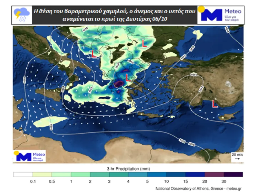
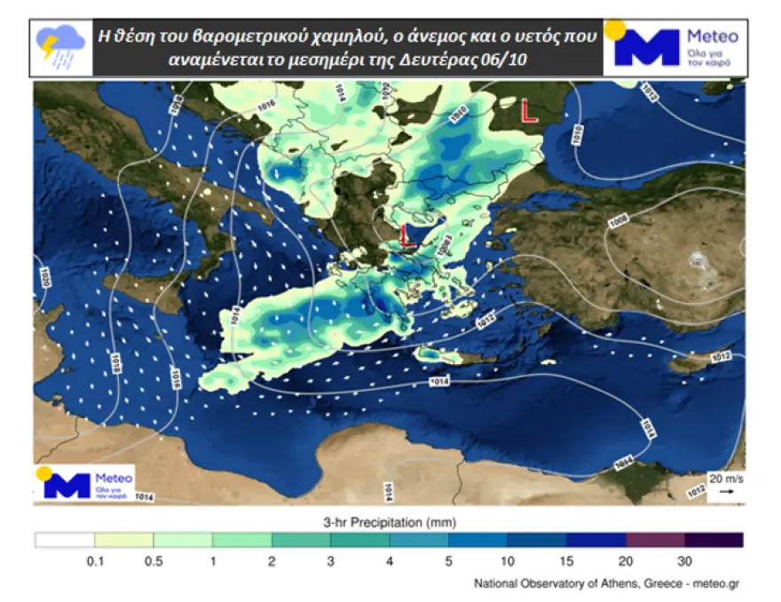
Weather maps illustrate the position of the low-pressure system, near-surface winds, and expected precipitation for (1) Monday morning, (2) Monday noon, and (3) early Monday evening.
Map 1: Low-pressure position, surface wind, and expected precipitation for Monday morning, October 6 Map 2: Same data for Monday noon, October 6 Map 3: Same data for early Monday evening, October 6
Kolydas: Heavy Showers and Thunderstorms Possible
Meteorologist Thodoris Kolydas noted that the National Weather Service (EMY) did not issue an “Emergency Dangerous Events Bulletin” but instead included the new weather system in the “Warnings” section of the general forecast.
“I inform you that EMY has chosen to include the warning for the new weather change in the general weather forecast and in the ‘warnings’ section,” Kolydas wrote.
“For Monday, it is stated: ‘Possibly locally heavy rain and thunderstorms in the Ionian Sea and western mainland until late afternoon, and in eastern Macedonia, Thrace, and the eastern Aegean islands from the afternoon until late at night.’”
Kolydas also shared a video showing hourly precipitation forecasts until Tuesday noon, October 7, for better public awareness.
Tsatrafyllas: Low-Pressure System “BARBARA” Arriving from the Gulf of Genoa
Meteorologist George Tsatrafyllas referred to the low-pressure system as “BARBARA”, arriving in Greece from the Gulf of Genoa.
“From this evening, the weather will gradually deteriorate for about 48 hours with rain, storms, gusty northerly winds, a drop in temperature, and local hail. It’s a typical autumn weather pattern — more beneficial than dangerous,” he wrote.
Tsatrafyllas also listed the areas expected to receive the heaviest rainfall and require special attention:
Monday: Western Greece, Chania, Macedonia, Thrace, and the northern Aegean islands. A few morning showers possible in Attica.
Tuesday: Thrace, northern and eastern Aegean islands, northern Cyclades, and the Dodecanese. A few afternoon showers possible in Attica.
Temperatures will drop by up to 8°C by Wednesday, with midday highs around 20°C. Cold conditions will be felt early in the morning and at night, especially in northern Greece, where single-digit temperatures are expected.
⛈️⚠️ΠΙΘΑΝΟΝ ΕΝΤΟΝΕΣ ΒΡΟΧΕΣ ΚΑΙ ΚΑΤΑΙΓΙΔΕΣ ✅Σας ενημερώνω ότι η ΕΜΥ επέλεξε την προειδοποίηση για τη νέα μεταβολή του καιρού να την εντάξει στη γενική πρόγνωση του καιρού και στην ενότητα "προειδοποιήσεις", όπου για τη Δευτέρα χαρακτηριστικά αναφέρεται: " Πιθανώς κατά τόπους… pic.twitter.com/XlENIxAY2f
On Monday and Tuesday, northerly winds in the Ionian and westerly winds in the southern Aegean will reach up to 8 Beaufort. From Wednesday onward, no new weather systems are expected, and temperatures will return to seasonal levels.
Forecast Details
Today (Monday, October 6)
Showers and thunderstorms are expected, initially in western Greece, gradually extending to the rest of the country. The most intense phenomena are forecast:
In the west, until morning
In the Peloponnese, from morning to noon
In Thrace, the eastern Aegean, and Crete, from the afternoon onward
Temperatures:
Western Macedonia: 10–19°C
Rest of Macedonia and Thrace: 11–20°C
Thessaly: 13–25°C
Epirus: 14–19°C
Central Greece & Peloponnese: 11–25°C
Ionian Islands: 17–22°C
North & East Aegean: 12–25°C
Cyclades: 15–24°C
Dodecanese: 18–23°C
Crete: 12–26°C
Winds:
Aegean Sea: Southerly 3–5 Beaufort, turning northerly 4–6 Beaufort in the north after afternoon
Ionian Sea: Southwesterly 3–5 Beaufort, turning northwesterly 4–7 Beaufort from morning to evening
Attica: Increasing clouds with rain and possible thunderstorms from noon. Winds: South–southwest 2–4 Beaufort, turning northwest later. Temperature: 17–24°C
Thessaloniki: Cloudy with rain until afternoon, locally strong in the morning. Winds: Variable up to 3 Beaufort, turning north 3–5 Beaufort later. Temperature: 16–19°C
Tuesday, October 7
Unsettled weather with intermittent showers and isolated thunderstorms across most areas. Intense phenomena are possible in Thrace, the eastern Aegean islands, and until noon in the Dodecanese.
Winds:
Eastern and southern Aegean: South 4–7 Beaufort, turning west-northwest
Rest of Greece: North-northwest 5–7 Beaufort, up to 8 Beaufort in the Ionian
Cloudy in the east and south with local showers and isolated thunderstorms, gradually improving. Elsewhere, partly cloudy with brief local showers. Winds: North 5–6 Beaufort, locally 7 at sea, weakening from afternoon. Temperature: Little change.
Thursday, October 9
Cloudy in the east with early showers or isolated thunderstorms, improving rapidly. Elsewhere, mostly clear with a few clouds. Winds: North–northwest 4–6 Beaufort. Temperature: Slightly higher.
Friday, October 10
Generally clear with some passing clouds, thicker in the west. Winds: