





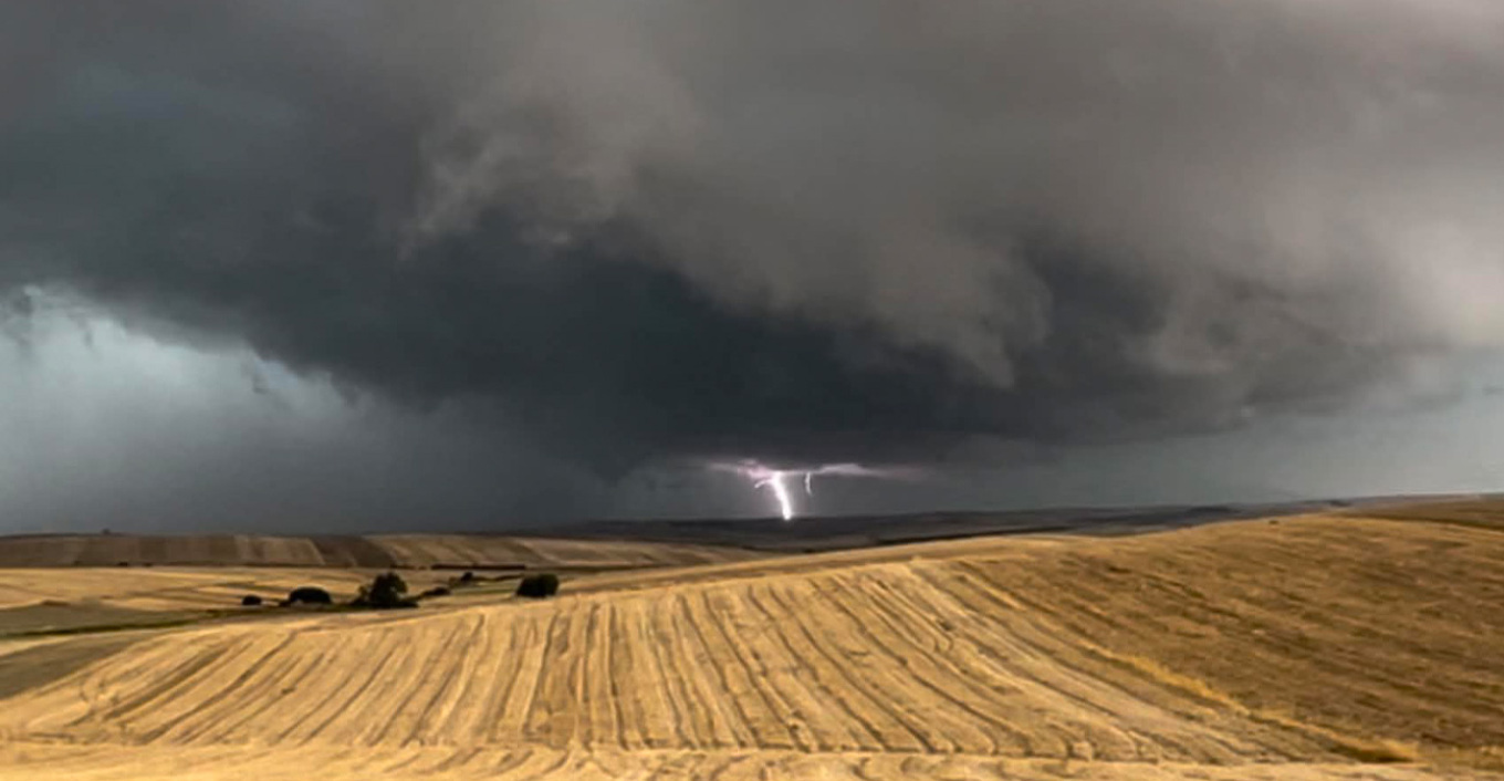
The sky over the city darkened as thick cloud rolled in, and shortly before 7pm on Friday afternoon (24 July), a heavy downpour began, accompanied by strong winds and intense lightning.
The wave of extreme weather has been under way across large parts of Greece since early in the day, with conditions described as severe in places. Roofs have been torn from buildings, roads have flooded, hail has destroyed crops, trees have come down, and whirlwinds have appeared along the coast, frightening swimmers, while more than 100,000 lightning strikes have been recorded nationwide.A wave of severe weather is sweeping across large parts of Greece, with intense phenomena reported nationwide. Roofs have been torn from buildings, streets have flooded, hail has destroyed crops, trees have been uprooted and waterspouts have appeared offshore, alarming swimmers.
Agrinio, Fthiotida, Thessaloniki, Zakynthos, Drama, Halkidiki and Volos are among the areas that saw weather conditions shift abruptly, with residents confronted by intense storms.
In many regions, residents received messages via 112, Greece’s national emergency alert system, warning of locally strong rain, storms and lightning activity from the early afternoon and continuing for the following 12 hours, urging heightened caution when travelling.
The areas placed on alert were Larissa, Fthiotida, central and northern Evia and Skyros, and Magnesia and the Sporades.
Wintry scenario on a Larissa beach, video:
Fthiotida: roof torn off, streets turned into rivers, trees uprooted
The most intense phenomena struck Fthiotida, where powerful rain, gale-force winds and hail caused problems across several parts of the prefecture. In western Fthiotida, streets flooded, trees fell and significant material damage was recorded, according to local outlet LamiaNow.
Within minutes, roads had turned into rivers, while strong winds uprooted trees and snapped large branches. Fallen trees were reported in Platystomo, Makri and Kastri, among other locations.
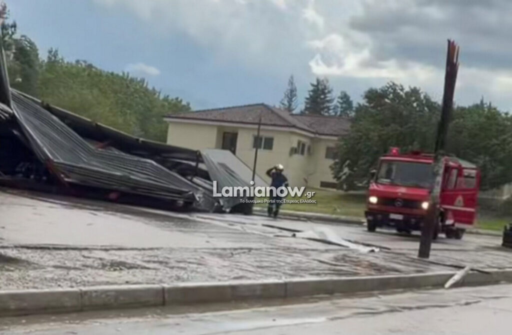

A particularly serious incident occurred in Makrakomi, where the roof of the building belonging to the Union of Agricultural Cooperatives was ripped off by the force of the wind and landed on the opposite side of the road, near a supermarket.
According to an eyewitness, the metal structure was carried around 100 metres by the wind. The severity of the winds also swept away metal sheeting, which landed near shops, creating a serious hazard for pedestrians and drivers.
Rain in Zakynthos, hail in Drama, storms in Thessaloniki, waterspout in Halkidiki
Residents of Zakynthos faced heavy rain, while in Drama, as seen in video footage, large hailstones covered the ground. In Thessaloniki, weather conditions changed abruptly, bringing strong winds and heavy rain, while swimmers on Psarouthia beach in Halkidiki were startled by a waterspout approaching the shore.
Waterspouts between Sithonia and Mount Athos
Striking footage captured waterspouts forming in the bay between Sithonia and Mount Athos. A fully formed waterspout, connecting the base of the storm cloud to the surface of the sea, is visible in the video, along with a funnel cloud, a rotating column of air descending from the cloud that has not yet touched or become visible on the sea’s surface, according to the caption accompanying the footage.
Lightning sparks fire in Kerasia, Magnesia
Heavy rain fell around midday on Friday (24 July) in the city of Volos and in mountainous areas, particularly Zagora on Mount Pelion, where high rainfall totals are expected. The sky darkened suddenly as the storm system began affecting Magnesia. The rain was accompanied by lightning, thunder and intense electrical activity, sparking a fire caused by a lightning strike in the Kerasia area of the Municipality of Rigas Feraios, according to Greek public broadcaster ERT.
Seven vehicles from the Volos Fire Service and four from the Volos Industrial Area Fire Service responded to extinguish the blaze. At the same time, the fire service’s call centre received continuous calls regarding fallen trees due to the severe weather affecting Magnesia.
Firefighters from the Volos Industrial Area Fire Service were also working on the Volos to Larissa national road, shortly after the 304 kilometre marker, to clear trees that had fallen onto the carriageway. Drivers were urged to exercise particular caution. The Volos Fire Service had earlier received a call to remove a fallen tree at the junction of Perseos and Apollonos streets in Nea Dimitriada. Magnesia and the Sporades remain under “Red Code” mobilisation status, with residents warned via 112 to take particular care when travelling.
Storm sweeps through Trikala
A powerful storm struck the town of Trikala on Friday afternoon, with torrential rain causing serious traffic problems.
According to local outlet trikalavoice.gr, within minutes central streets had turned into torrents, while visibility dropped significantly, forcing drivers to slow considerably. Standing water was reported in several locations, with pedestrians seeking shelter until the storm eased.
The storm was accompanied by intense lightning activity, strong gusts of wind and, in parts of the prefecture, hail, including in Gerakari.
Difficult driving conditions on the Athens to Lamia motorway
Conditions remain intense in places along the Athens to Lamia motorway, with traffic moving with difficulty as drivers face limited visibility, as shown in footage from protothema.gr.
112 alerts issued across multiple regions for severe storms and lightning
Residents and visitors in many parts of the country received alerts via 112 due to the severe weather. The alerts warned of locally strong rain, storms and lightning activity from the early afternoon and continuing for the following 12 hours, urging heightened caution when travelling.
The areas placed on alert were Larissa, Fthiotida, central and northern Evia and Skyros, and Magnesia and the Sporades.
112 Greece issued a series of alerts on 24 July 2026, warning of locally strong rain, storms and lightning activity expected in the regional units of Magnesia and the Sporades, Fthiotida, and Larissa respectively, from the early afternoon and continuing for the following 12 hours, and urging residents to follow the instructions of the authorities.
When is the weather expected to improve?
According to Meteo, a gradual improvement in weather conditions is expected from late Friday evening, with localised phenomena persisting only in the central and eastern Aegean until early Saturday morning (25 July).
Emergency bulletin from the National Meteorological Service (EMY) remains in full force
A difficult 24 hours lies ahead, according to protothema.gr meteorologist Giorgos Tsatrafyllias, as a wave of severe weather affects large parts of the country, with intensity and persistence varying by region.
The phenomena are expected to be intense, accompanied by heavy lightning activity, hail and very strong gusts of wind, which may bring down trees, branches and objects. There is also a risk of flash flooding, particularly in areas where storms prove especially intense and prolonged.
The areas at greatest risk are Larissa, Magnesia, particularly coastal areas, Evia and the Sporades. A defining feature of this system is the persistence of phenomena in these specific regions, from midday on Friday through to Saturday morning.
Second in line of risk are the coastal areas of Pieria, Imathia and Halkidiki, along with Lemnos, Thasos, Samothraki and Attica. In most of these areas, conditions are expected to ease in the early hours of Saturday morning, with the exception of Attica.
In Attica, rain is expected over the coming hours, with periods of strong storms, mainly in the northern and eastern parts of the region. Conditions are expected to ease in the early hours of Saturday morning. Temperatures will range from 20 to 29 degrees Celsius, with northerly winds locally reaching force 6 on the Beaufort scale.
In Thessaloniki, unsettled weather is expected, with rain and locally strong storms. Conditions will ease in the evening hours. Winds over the Thermaic Gulf will blow northwesterly up to force 5, with temperatures not exceeding 23 degrees Celsius.
Temperatures will also drop further, reaching 28 to 29 degrees Celsius on the mainland and 30 to 32 degrees Celsius in the Cyclades, Crete and the Dodecanese.
Winds will blow from northerly and northwesterly directions, reaching force 7 in the Ionian Sea and the southeastern Aegean.
Weather conditions are expected to improve gradually on Saturday, with a return to typical summer conditions from Sunday, alongside rising temperatures.
New emergency bulletin from EMY on worsening conditions: when and where the strongest phenomena will begin
The Emergency Bulletin for Hazardous Weather Phenomena issued on 23 July remains in effect, according to the latest forecast data.
Severe weather is forecast from Friday 24 July 2026 through to the late morning hours of Saturday 25 July 2026 in most parts of the country, with the main characteristics being strong rain and storms. In many areas, these phenomena will be accompanied by locally strong winds (squalls), frequent lightning and the possibility of localised hail.
Strong rain and storms are specifically forecast as follows:
Friday 24 July
- In central Macedonia (the prefectures of Pieria, Imathia, Halkidiki and Thessaloniki), from the late morning hours until late evening (orange warning).
- In eastern Thessaly (the prefectures of Larissa and Magnesia), from midday until late at night (orange warning), and particularly over sea and coastal areas (red warning).
- In the Sporades and Evia (mainly central and northern Evia), from midday (red warning).
- In eastern Sterea Ellada, including Attica, from the afternoon until late evening (orange warning).
- On the islands of the northeastern Aegean (Lemnos, Thasos, Samothraki), from late evening (orange warning).
Saturday 25 July
- In the Sporades, until the morning hours (red warning).
- In Evia (mainly central and northern), until the late morning hours (red warning).
- On the islands of the northeastern Aegean (Lemnos, Thasos, Samothraki), until the early morning hours (orange warning).
- In Magnesia (mainly eastern sea and coastal areas), until the early hours (orange warning).
Ask me anything
Explore related questions




