
Many areas in western Greece experienced a difficult night, as severe weather system Adel is causing floods, stream overflows, landslides and operational disruptions, while emergency alerts via 112 have been sent to Corfu and Aitoloakarnania urging residents to limit movement. The intense weather phenomena are expected to escalate in the coming hours and affect a large part of the country.
According to local authorities, the most serious problems are found in Potamos, where all the roads are covered with water, as well as in the Alepou plain and Triklino, where a stream overflowed. In the areas of Agioi Deka, Benitses and Dassia, retaining walls collapsed, increasing travel hazards.
The Fire Service is receiving continuous calls for pumping water from basements, ground floors and businesses, as well as for fallen trees. The weather also disrupted municipal operations, as the planned Municipal Council meeting was cancelled due to flooding in the hall from water entering through the roof. It has already been announced that schools in the Municipality of Central Corfu will remain closed today.
Similar problems occurred in Zevgaraki in the Municipality of Agrinio, where a nearby stream overflowed and municipal machinery had to intervene immediately to carry out clearing work and protect residential areas.
At the same time, an alert from the 112 emergency service was sent on Wednesday night to residents of Aitoloakarnania and Corfu.
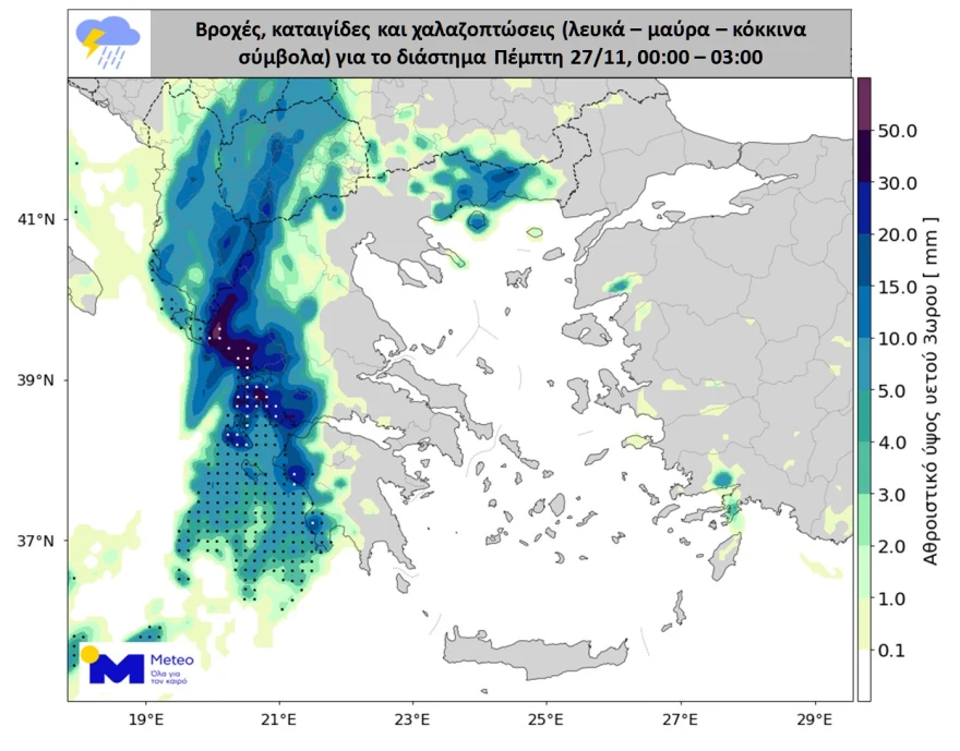
According to forecasting data from meteo.gr / National Observatory of Athens, very heavy rain and thunderstorms are expected today in the Ionian Islands, Epirus, western and central mainland Greece, western and southern Peloponnese, central and eastern Macedonia and Thrace. In these areas, hail may be large in size, and muddy rain is also expected due to the transport of African dust. Winds will blow from the south at 6–8 Beaufort over the seas.
The rainfall event is classified as Category 5 — the highest level on the scale, indicating extreme phenomena.
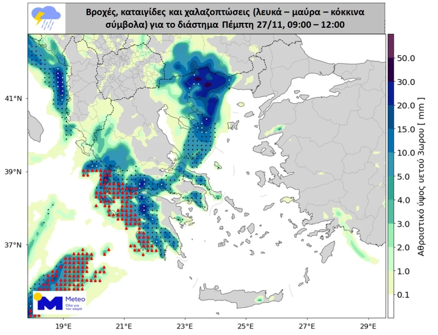
On Friday, November 28, severe weather will continue, heavily affecting the Eastern Aegean islands and the Dodecanese, while strong rain and thunderstorms will persist in western Greece until early morning.
Meteorological maps accompanying the forecasts show a high probability of hailstorms, with indications of hail larger than two centimeters in some areas, as well as zones expecting significant quantities of hail.
The HNMS (EMY) Emergency Weather Warning
According to the emergency deterioration bulletin of the Hellenic National Meteorological Service (EMY), the weather system named ADEL will bring rain and thunderstorms across almost the entire country on Thursday (27-11-25) and Friday (28-11-25). The phenomena will be strong in many parts of western and northern Greece as well as the eastern Aegean, accompanied by local hailstorms and occasionally very strong winds.
More specifically:
On Thursday (27-11-25) strong rain and thunderstorms are expected in:
- the Ionian Islands
- Epirus
- western and central mainland Greece
- western and southern Peloponnese
- central and eastern Macedonia
- Thrace
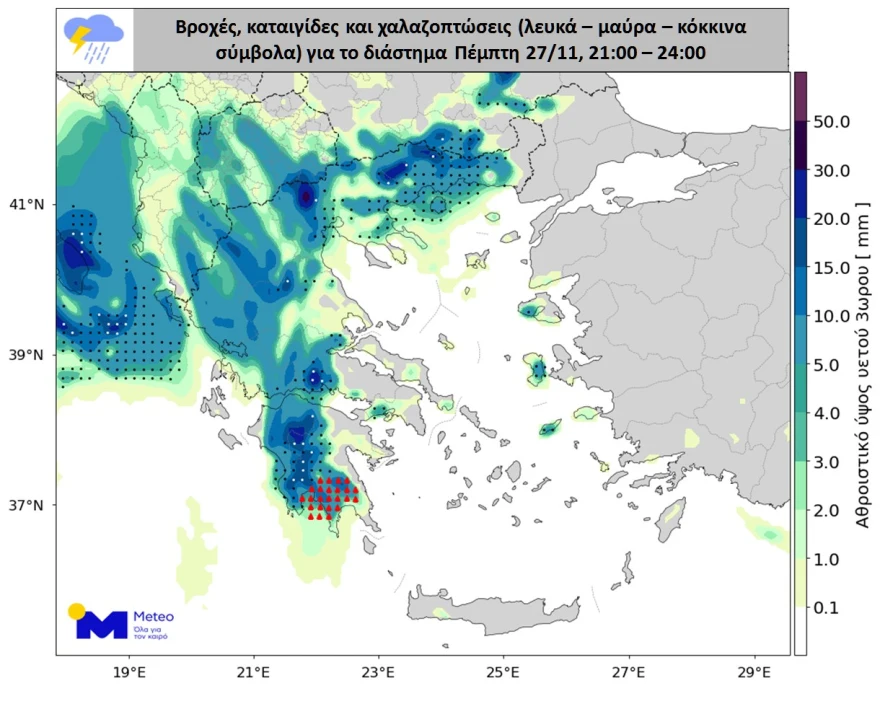
On Friday (28-11-25) strong rain and thunderstorms are expected in central and eastern Macedonia, Thrace, the eastern Aegean, and until early morning in western Greece.
Problems in Corfu – 112 Alerts
Heavy rainfall has caused significant issues on Corfu. The EMY emergency bulletin for severe weather Adel is in effect, with 112 sending alerts to residents of Aitoloakarnania and Corfu advising them to limit movement.
“Due to heavy rainfall and landslides in the Regional Unit of Aitoloakarnania, restrict your movements to those strictly necessary,” reads the 112 alert. Theodoros Kolydas stated earlier that the storm cloud top in Aitoloakarnania exceeded 11 kilometers in height.
Flooding in Corfu
The storm began yesterday around 19:30, and within an hour the roads had turned into rivers and torrents, trapping many drivers, while the Fire Service received successive calls.
Many roads on the island have flooded, according to corfutvnews.gr. Fire Service teams have been called to pump water in Kokkiní and Potamos, where all roads are flooded, and in Kira Chryssikou, where a tree fell, according to kerkyrasimera.gr. At the bridge in the village of Afra, waters have risen significantly, while the main road in Kokkiní has become a river.
Retaining wall collapses were observed in Agioi Deka and Benitses, and in Dassia. Major problems have also occurred in the Alepou plain and Triklino, where a stream overflowed.
The Mayor of Central Corfu, Stefanos Poulimenos, wrote in a post that the river in the area is at risk of overflowing. Due to the severe weather, the Municipal Council meeting did not take place as the hall flooded from water entering through the roof.
Flooding in Aetolia-Acarnania
Floods occurred in Zevgaraki, Agrinio, when a large volume of debris from a nearby stream was carried into a residential area, causing problems and water entering nearby homes, according to sinidisi.gr.
The Technical Service of the Municipality of Agrinio intervened immediately. Heavy machinery was brought in to remove debris and restore the water flow to prevent further damage.
Severe weather is also hitting Rivio, Aitoloakarnania, with large amounts of water falling in a very short time. Torrents are at critical levels, as water levels keep rising due to continuous rainfall, according to aitolianews.gr.
Agrinio: Stream Overflow in Zevgaraki
Severe rainfall caused problems in the Zevgaraki area of the Municipality of Agrinio.
Specifically, a neighboring stream overflowed, requiring intervention by municipal machinery to carry out clearing works and protect residential areas.
Flight Returned to Athens
Last night’s Aegean flight from Athens to Corfu, despite the pilot’s efforts, failed to land and at 20:30 returned to Athens.
According to reports, a woman in Corfu who had recently undergone a Caesarean section needed immediate hospital transport, requiring Fire Service intervention for safe transfer.
Meanwhile, the Corfu Police Directorate issued an announcement imposing a traffic ban on Sp. Armenis Street, as the road has become a torrent and vehicle passage is impossible. Authorities urge citizens to avoid unnecessary travel, follow instructions and stay safe.
The Ionian Islands General Police Directorate announced that “vehicle traffic is currently difficult on the inbound lane of National Road Paleokastritsa in Corfu near Agia Aikaterini, and traffic has been suspended on Spyrou Peroulaki Street in the Potamos area due to problems caused by heavy rainfall.”
Closed Schools
Schools will remain closed today, Thursday, November 27, 2025, across all primary and secondary education units, as well as nurseries and childcare centers, in the Municipality of Central Corfu and Diapontian Islands, and the Municipality of South Corfu.
The decision was made due to severe flooding caused by the torrential rains on Wednesday afternoon and night, as well as wall collapses and slope failures at many locations. These conditions make student access to schools difficult and potentially dangerous.
School closures have also been announced for all educational units within the Municipality of Xiromero for Thursday, November 27, 2025.
Kolydas’ Warning for Western Peloponnese and the Ionian
Theodoros Kolydas reports the latest forecasting data, according to which in the next 24 hours significant worsening of weather is expected, with particularly intense lightning activity and increased risk of hail in two main regions of the country. Western mainland Greece—especially western Peloponnese and the Ionian—forms the highest-risk area, as extensive electrical activity and a high probability of large hailstones are forecast, particularly in Ilia, Achaia, Messinia and the coastal areas of Aitoloakarnania. Strong winds may develop locally, with potential water accumulation, as the combination of increased atmospheric instability and dynamic support at 500 hPa enhances the likelihood of severe phenomena.
Significant activity is also expected in Eastern Macedonia and Thrace, where developing storms may present high lightning density and small hail, according to Kolydas on kolydas.eu. Areas such as Kavala, Paggaio, Serres, Drama, southwestern Rhodope and the coastal areas of Xanthi lie within high-risk zones, as the configuration of air masses over the Thracian Sea enhances local instability.
The most intense phenomena will initially occur in the Ionian Islands, western mainland Greece, the Peloponnese, and also in Eastern Macedonia and Thrace, where rain and thunderstorms will intensify. Particularly in the western regions, thunderstorms are expected to be accompanied by hail—locally severe—and Thursday is forecast to be a day of high danger. Hailstorms are likely, with western mainland Greece and the Ionian Islands having the highest probability for large hail. Rain and scattered thunderstorms will also occur in the rest of the country, with occasional intense phenomena possible even in Athens and Thessaloniki.
The severe weather will persist into Friday, November 28, with the most intense phenomena shifting to the Eastern Aegean islands and the Dodecanese.
Today’s Weather
Heavy and locally very heavy rain and thunderstorms will occur intermittently in the Ionian Islands, western mainland Greece, the Peloponnese, Eastern Macedonia and Thrace, accompanied locally by hail. In the Ionian, western mainland Greece and secondarily the Peloponnese, hail may be relatively large. Elsewhere, rain and scattered thunderstorms will also occur, occasionally intense. Areas affected include Athens and Thessaloniki. There will also be significant transport of African dust, leading to muddy rain.
Temperatures:
- Western Macedonia: 5–13°C
- Rest of Macedonia & Thrace: 10–17/19°C
- Thessaly: 9–17/18°C
- Epirus: 9–16/17°C
- Rest of mainland: 11–19/22°C
- Ionian Islands: 14–18/19°C
- Aegean Islands & Crete: 15–20/23°C
Winds in the Aegean and Ionian will blow from southern directions at 6–7 Beaufort, possibly locally 8.
Attica (Athens area):
Rain or thunderstorms at intervals. Phenomena may be locally intense and accompanied by hail. Winds from the south at 4–5 Beaufort, possibly locally 6. Temperature: 16–19/20°C.
Thessaloniki:
Rain or thunderstorms mainly in the morning and evening hours. Winds from the south-southeast up to 5 Beaufort. Temperature: 15–18°C.
Friday, November 28 Weather
Clouds with rain and scattered thunderstorms in most of the country. The phenomena in central and eastern Macedonia, Thrace, the eastern Aegean and until early morning in western Greece will be locally very strong, with hail and occasionally very strong winds. Brief snowfall will occur in the mountains of Epirus, Macedonia, Thessaly and western mainland Greece.
Winds from the south:
- West: 3–5 Beaufort
- East & south: 4–6 Beaufort
- Aegean: locally 7 Beaufort
Temperature will drop slightly nationwide.
Saturday, November 29 Weather
Clouds with periods of increased cloudiness and local rain in most areas. Scattered thunderstorms in the Ionian, eastern Macedonia, Thrace, the Cyclades, Crete, the eastern Aegean and the Dodecanese. The phenomena in the eastern Aegean and the Dodecanese will be strong but gradually weaken after midday. Visibility will be locally limited in the morning and evening in mainland areas.
Winds:
- West: northerly 3–5 Beaufort
- East: initially southerly 4–6 Beaufort, turning to west-northwest with slight weakening after midday
Temperature will drop slightly further.
Sunday, November 30 Weather
In the eastern Aegean: some clouds, locally increased, with occasional rain and isolated thunderstorms until midday.
In the rest of the country: partly cloudy with periods of increased cloudiness and a chance of light local rain in the west and south until afternoon. Visibility will be locally limited in the morning and evening in mainland areas.
Winds: northwest 3–4 Beaufort, and in the Aegean locally 5.
Temperature: no significant change.
Ask me anything
Explore related questions


