
A new spell of severe weather begins this afternoon, with rain and thunderstorms gradually spreading across the entire country, while snowfall is expected in mountainous regions. The areas most likely to be affected include western, eastern, and southern Greece, with strong winds and locally intense phenomena lasting through the end of the week.
The system enters Greece from the west, with rain appearing from Tuesday afternoon and significantly increasing on Wednesday.
According to meteorologist Thodoris Kolydas, the week is expected to be rainy, with the intensity and distribution of the phenomena depending on the exact path of the incoming low. As the system moves eastward, rain will gradually cover the entire country, while snowfall is expected in the mountains of central and northern Greece. Winds will strengthen toward the end of the week, without causing concern, and temperatures will remain seasonally normal.
☃︎🎅🎄❄️☃️🎁🦌Καλημέρα καλό μήνα και καλή εβδομάδα
— Theodoros Kolydas (@KolydasT) December 1, 2025
✅Βροχερή προβλέπεται η νέα εβδομάδα, με κατά τόπους έντονα φαινόμενα, καθώς η κατανομή και η ένταση του υετού θα εξαρτηθούν —όπως πάντα— από την ακριβή τροχιά της επερχόμενης ύφεσης. Οι βροχές θα κάνουν την εμφάνισή τους από… pic.twitter.com/go428IT08j
Meteorologist Giorgos Tsatrafyllias, meanwhile, refers to an “African storm” that will form on Wednesday along the northern coast of Africa, in Libya, specifically in the Gulf of Sidra. The low-pressure system will move rapidly toward Greece and affect a large part of the country through the end of the week, bringing heavy rain, thunderstorms, and strong southerly winds.
The areas expected to be most affected include Western Greece—especially regions near the Ionian Sea—southern Peloponnese, Thessaly, Evia, eastern Central Greece, Attica, the Sporades, Central Macedonia, the eastern Aegean, the Cyclades, the Dodecanese, and Crete. Phenomena will begin on Wednesday in the west and within hours spread to most regions.
Prevailing winds will be southerly, shifting to northerlies from Saturday. Temperature changes will be minor, while snowfall will occur at high elevations and in certain ski resorts. Tsatrafyllias notes that day-to-day updates will provide more precise information on intensity and affected areas.
At the same time, early—and typically premature—discussions about Christmas weather have already started. However, meteorologists emphasize that the priority is the evolution of the coming days’ severe weather, as the new system is expected to impact the country through the end of the week.
November 2025: Extremely high rainfall in Western Greece and Epirus – Over 1000 mm in Tzoumerka
November 2025 was marked by exceptionally high rainfall, mainly in Western Greece and Epirus, according to data from the extensive network of automatic weather stations operated by meteo.gr / National Observatory of Athens. The distribution of total monthly precipitation over Greece for November 2025 is shown in the map in Image 1.
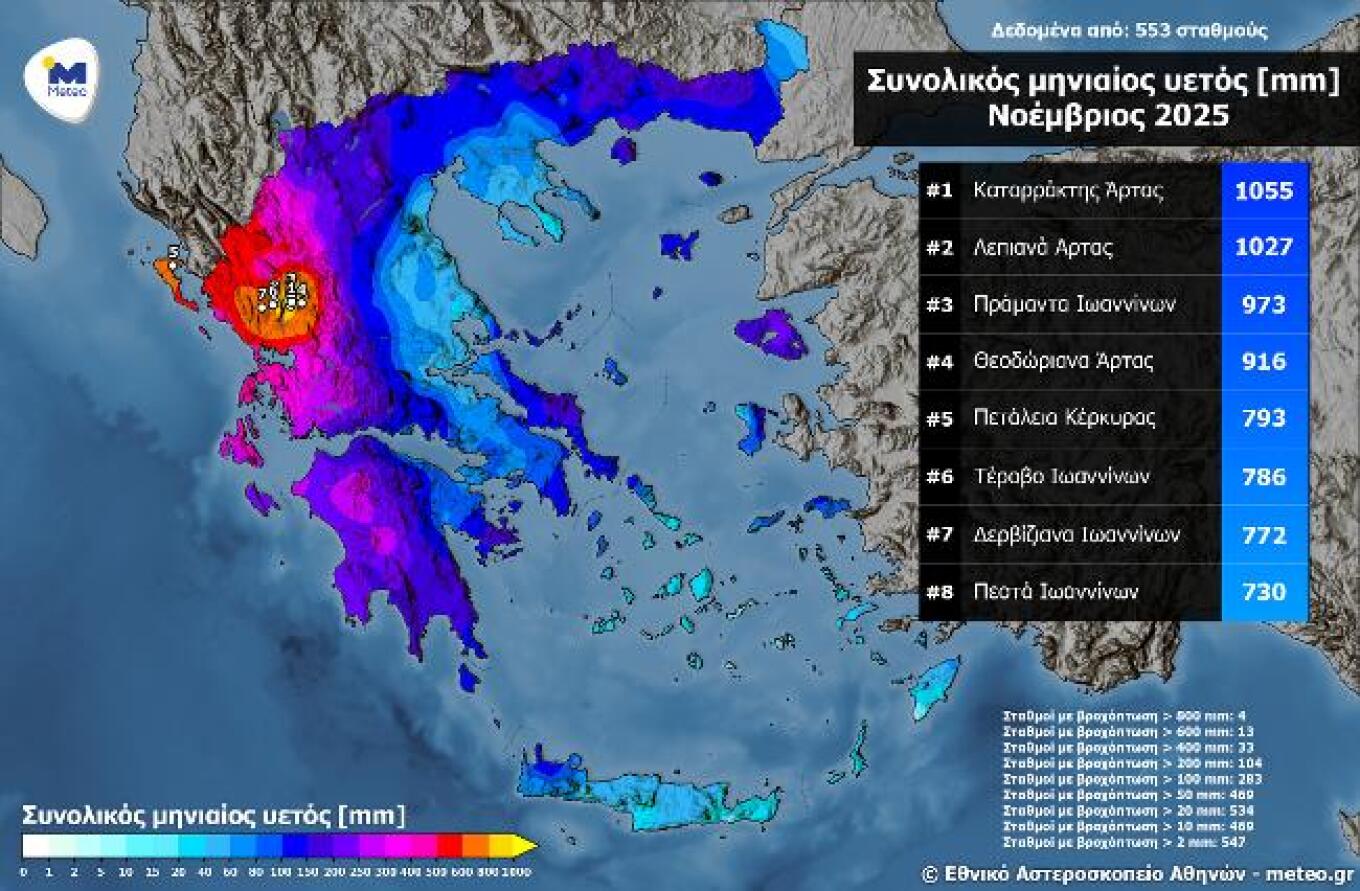
Image 1. Total monthly precipitation for November 2025 as recorded by the meteo.gr / National Observatory of Athens weather station network.
According to the chart, four stations recorded more than 800 mm of rainfall, 13 stations more than 600 mm, 33 stations more than 400 mm, while 283 stations recorded over 100 mm (51% of all active stations). The highest monthly total was recorded in Kataraktis, Arta, with 1055 mm, with slight underestimation due to brief data-transmission interruptions.
Exceptionally high rainfall totals were observed in Epirus, and especially in the mountainous Tzoumerka region, where precipitation exceeded 1000 mm in a single month. The November 2025 precipitation totals at Kataraktis and Lepiana (Arta) are among the ten highest monthly rainfall amounts ever recorded since the network’s establishment. The ten highest monthly totals fall mainly within three intense weather periods: February 2019 (storms Chioni and Oceanis), September 2023 (storms Daniel and Elias), and November 2025 (storms of 18–22/11 and storm Adel).
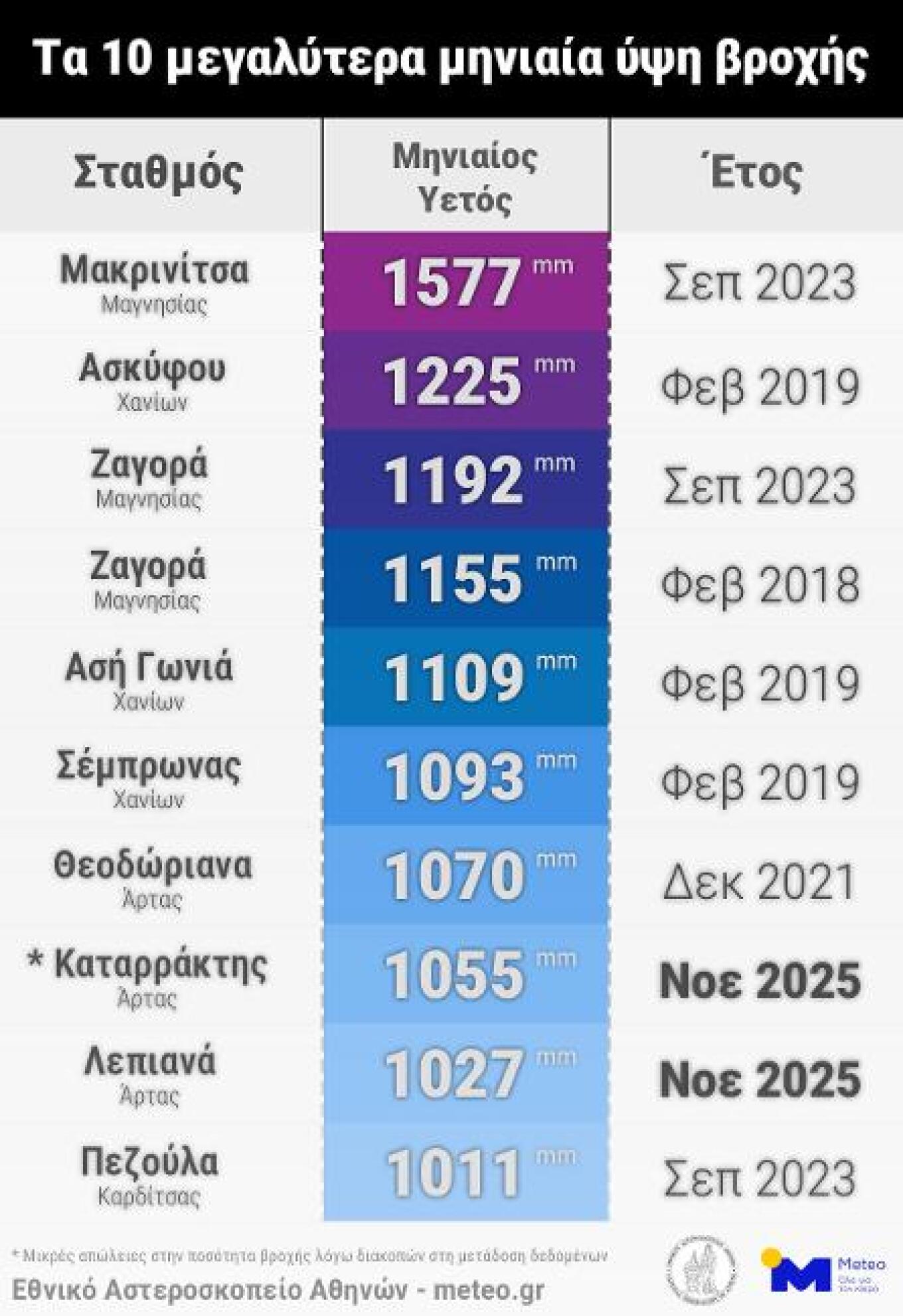
Image 2. The 10 highest monthly rainfall totals from the meteo.gr / National Observatory of Athens weather-station network.
Today’s weather
Cloud cover will gradually thicken, with local rain in Western Greece and Crete and isolated thunderstorms in the Ionian. Visibility will be locally limited during the night and early morning hours.
Temperature ranges:
• Western Macedonia: –1 to 9°C
• Rest of Macedonia & Thrace: 3 to 13°C
• Epirus & Thessaly: 4 to 14°C
• Central Greece & Peloponnese: 3 to 17°C
• Ionian: 11 to 17°C
• Aegean: 7 to 18°C (up to 16°C in the North Aegean)
• Crete: 8 to 19°C
Winds will be light and variable; in the west, southeast winds at 3–5 Beaufort.
Attica: Cloudy skies; light variable winds; temperatures 7–17°C (2–3°C lower in the east).
Thessaloniki: Cloudy; northwesterly then variable winds 2–3 Beaufort; temperatures 6–14°C.
Wednesday, December 3
In Eastern Macedonia, Thrace, the Cyclades, and the eastern island regions, cloud cover with local showers in the Cyclades from the evening. Elsewhere, increasing clouds with rain in the Ionian, western mainland, and gradually the central and eastern mainland and Crete. Thunderstorms mainly in the Ionian and western coastal areas, possibly southern Peloponnese and southern Crete. Phenomena in the Ionian may be intense. Light snow in the mountains of Epirus and Macedonia.
From evening, conditions favor partial transport of Saharan dust in western and southern Greece. Morning visibility will be locally limited.
Winds: E–SE 3–5 Beaufort, 4–6 in the Ionian, locally 7 Beaufort at night.
Temperatures unchanged: 14–16°C in the north; 16–18°C in Ionian, N. Aegean, and mainland; 19–21°C in the south Aegean.
Thursday, December 4
In Thrace, thin clouds occasionally thicker. Elsewhere, widespread cloud cover with rain and sporadic coastal thunderstorms. Phenomena may be intense in the Ionian, the Cyclades, southern Crete, and western Central Macedonia.
Winds: E–SE 4–6 Beaufort, up to 7 in the Ionian and central/southeast Aegean.
Temperatures will rise slightly.
Friday, December 5
In eastern Greece, clouds with rain and thunderstorms—possibly locally strong. In the west, unstable conditions with intermittent cloud and local showers or isolated storms. Temporary snow in the central and northern mountains. Conditions favor temporary Saharan dust over eastern regions.
Winds: E 4–6 Beaufort; 7–8 Beaufort in SE Aegean. Later shifting to W–NW in the west.
Temperatures steady.
Saturday, December 6
In central & northern mainland, southern Ionian, northern & eastern Aegean islands—and later Cyclades & Crete—clouds with rain and sporadic coastal thunderstorms, possibly locally strong. Elsewhere, cloudy at times with brief local showers. Light snow in central & northern mountains.
Winds: In the west, variable 2–4 Beaufort shifting NW; in the east, southerlies 3–5 Beaufort, locally 6 in the Aegean.
Temperatures will drop slightly, mainly in the south.
Ask me anything
Explore related questions


