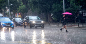
The country is under a state of heightened alert due to the hazy weather Erminio, with seven regions put on “red” alert and severe phenomena affecting especially Attica, Thessaly, Central Greece and the southern Aegean. At the same time, it was decided to keep schools closed in areas expected to be most affected by heavy rainfall and gusty winds.
Two storm waves in Attica
According to meteorologist Thodoris Kolydas, two successive bouts of bad weather are expected in Attica during the day.
The first phase is forecast to occur in the early morning hours, around 08:00 to 10:00, with gradual strengthening through midday.
The second and most intense surge is expected from the afternoon to evening, approximately between 15:00 and 21:00, with the highest intensities occurring towards the end of the period.
🏃🏾ΝΕΟ “RUNNING” FOR ATTICA
✅ Attica will see two flare-ups . The first one seems to start in the morning hours, around 08:00-10:00, and gradually intensifies until noon . The second and more notable one appears from the afternoon to the evening, around… pic.twitter.com/QIs3NBIA5w– Theodoros Kolydas (@KolydasT) March 31, 2026
As he explains, the precipitation systems move according to the wind flow at 700 hPa, which means that clouds and showers will be organised from south to north, affecting the regions differently in terms of intensity and duration.
Red alert in seven regions
A state of heightened alert is set:
Central Greece
Thessaly (including Sporades)
Peloponnese
(including the region of Greece).
South Aegean
Imathia
Pieria
central Macedonia
Attica is once again at the center of the bad weather, with the phenomena being characterized as particularly intense and long-lasting.
Live the course of the bad weather
Extraordinary Weather Warning Bulletin
According to the updated Extraordinary Bulletin of Dangerous Weather Phenomena, heavy rain and thunderstorms are forecast across most of the country on Wednesday, April 1 and Thursday, April 2, 2026.
Today, strong east-southeasterly winds will affect the eastern parts of the country, reaching 7–9 Beaufort, and locally up to 10 Beaufort in the Dodecanese. Heavy snowfall is expected in the mountainous areas of Epirus and Macedonia.
Heavy Rain and Thunderstorms Forecast
Wednesday, April 1
Severe weather is expected in the following areas:
- Ionian Islands: from early morning (orange warning)
- Southwestern Peloponnese: from midday (orange warning)
- Eastern Peloponnese: from midday to late night (red warning)
- Eastern Central Greece, Evia, Thessaly, Sporades: from midday to late night (red warning)
- Pieria: from midday to late night (orange warning)
- Attica: from midday to late night (red warning)
- Northern Cyclades: afternoon to late night (orange warning)
- Eastern Aegean islands: late afternoon to night (orange warning)
- Dodecanese: from afternoon (red warning)
- Eastern Crete: afternoon–evening (orange warning)
Thursday, April 2
- Western & Southern Peloponnese: morning to late night (red warning)
- Eastern Thessaly (Larissa, Magnesia, Sporades): early morning to midday (orange warning)
- Central Macedonia (Pieria, Imathia, Halkidiki, Serres): morning to late afternoon (orange warning)
- Crete (mainly west & south): midday to late night (red warning)
- Eastern Aegean islands: from late afternoon (orange warning)
- Dodecanese: early hours (red warning), again from late afternoon (orange warning)
Strong Winds and African Dust
Very strong winds are expected across the South Aegean, especially in Crete, the Cyclades, and the eastern and southeastern Aegean. Gusts may reach 90 km/h, locally exceeding 100 km/h.
At the same time, African dust transport will affect much of the country. Dust concentrations will increase from the morning, peaking around midday, especially in:
- Crete
- Peloponnese
- Cyclades
- Southern and eastern Aegean
- Eastern Central Greece
School Closures
Due to the severity of the weather, schools will remain closed in:
- The Cyclades and Dodecanese
- The municipality of Mantoudi–Limni–Agia Anna (Evia)
- The municipality of Karditsa
- The municipalities of Markopoulo and Saronikos (Attica)
- Night schools in Attica
Schools in the rest of Attica are expected to operate normally, though local authorities may revise decisions depending on conditions.
Remote Learning Measures
Where schools are closed by decision of local authorities, remote learning will be implemented where possible, according to the Ministry of Education.
Authorities state that tele-education will be activated immediately when needed to ensure continuity of the educational process.
Weather Overview – Wednesday
Rain and thunderstorms will begin early in the Ionian Islands and western Greece, spreading rapidly across the country. The most affected areas will include:
- Central and eastern mainland
- Eastern and southern Peloponnese
- Cyclades and Crete
- Eastern and southern Aegean
Snowfall is expected in mountainous regions, while dust concentrations will be high in many areas.
Temperatures will range from:
- 1–8°C in Western Macedonia
- up to 18°C in the Aegean islands and Crete
Attica
Rain in the morning, with thunderstorms from midday through the night.
Winds: easterly 4–5 Beaufort, turning southerly later.
Temperature: 8–16°C
Thessaloniki
Light rain early, intensifying from midday with possible thunderstorms.
Winds shifting from southeast to northeast (up to 6 Beaufort).
Temperature: 6–14°C
Outlook
Thursday, April 2
Unsettled weather continues with widespread rain and storms, locally severe. Temperatures will slightly decrease in the south.
Friday, April 3
Rain and storms mainly in the Peloponnese, Cyclades, Crete, and eastern Aegean, gradually weakening in the west.
Saturday, April 4
Showers and isolated storms, especially in the east and south, improving later in the day.
Sunday, April 5
Rain and isolated storms in eastern mainland and southern regions, with gradual improvement from the afternoon.
Ask me anything
Explore related questions