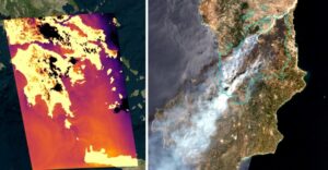
In recent days, Greece took a decisive step forward in its space and technological development with the launch of four thermal satellites as part of the National Microsatellite Program. The Athens-Macedonian News Agency (AMNA) released the first images from the new Greek space mission, which represents not only technological progress for the country, but also a fundamental change in how the state will manage crises, especially forest fires and the effects of the climate crisis.
The mission signals Greece’s move away from dependence on satellite data from third countries and organizations toward a new era of national operational independence, with the ability to access critical information almost in real time. For the first time, the country now has its own thermal “eyes” in space, capable of monitoring active wildfires, detecting new fire outbreaks, and continuously supplying data to the operational centers of Civil Protection and the Fire Service.
The thermal satellites are part of the broader €200 million National Space Program of the Ministry of Digital Governance, implemented with the support of the European Space Agency (ESA) and the Hellenic Space Center (ELKED). The main goal of the program is to develop full national capability in Earth Observation services for civil protection and natural disaster management.
With the launch of the thermal satellites, Greece now has, for the first time, a comprehensive national wildfire monitoring system that enables the early detection of fire outbreaks, continuous monitoring of their development in near real time, and accurate mapping of burned areas and their impacts. At the same time, it provides critical support for decision-making in the operational response of the competent authorities.
The Minister of Digital Governance, Dimitris Papastergiou, speaking to AMNA, emphasized that “through the use of thermal satellites, Greece is entering a new era in Civil Protection, where information does not arrive after the fact, but almost in real time.” As he underlined, “for the first time, we are acquiring a national capability for continuous wildfire monitoring, substantially strengthening prevention, early detection, and operational response.”
He also noted that “the data produced are integrated directly into the country’s operational systems, giving frontline personnel a better picture, faster decision-making capabilities, and more effective coordination,” adding that “this represents a substantial upgrade in the way we manage crises.” He further stressed that “the National Microsatellite Program is not only about technology, but about creating real capabilities for the country, with a direct impact on citizen safety, environmental protection, and the resilience of the economy.”
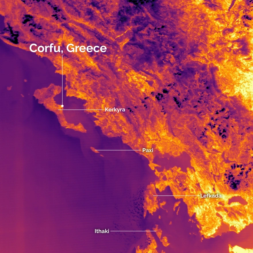
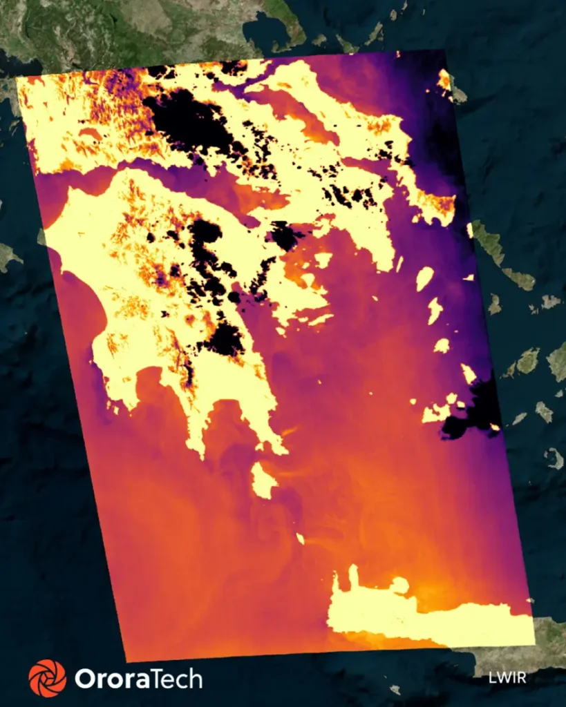
With the launch of the first Greek thermal satellites, the country gains, for the first time, the ability to continuously monitor wildfires operationally using national resources, significantly strengthening the capabilities of the Fire Service and Civil Protection at every stage of crisis management — from prevention and early detection to operational response and recovery. Thermal data make it possible to identify thermal anomalies and new fire outbreaks almost in real time, even in inaccessible areas or during the night, while also supporting the monitoring of fire-front expansion and the accurate mapping of burned areas.
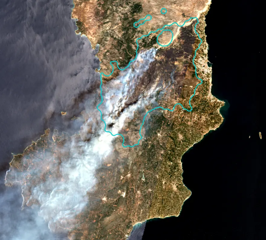
Particularly important is the operational integration of satellite data with the country’s existing crisis-management systems. OroraTech, in cooperation with Greek agencies and companies, has already integrated the wildfire solution platform and active-fire data into the operational systems of the Hellenic Fire Service, especially the ENGAGE command system, enabling a continuous flow of information to the Operational Coordination Centers for Crisis Management (ESKEDIK). Through this integration, operational personnel gain direct access to active-fire maps, risk assessments, thermal anomalies, spread forecasts, and detailed geospatial data that support decision-making in the field.
At the same time, data from thermal, SAR, and optical satellites are gathered in the Governmental EO Hub (Governmental Earth Observation Hub), creating a unified national environment for the management and sharing of geospatial information. The hub provides near-real-time Analysis-Ready Data, combining information from all Greek satellites as well as from European and international missions such as Copernicus Programme and Landsat Program. Through a unified and user-friendly platform, competent authorities can gain immediate access to critical information, analytical tools, and automated alerts, significantly reducing the time needed to acquire and utilize information in emergency situations.
The added value of integrating the wildfire solution platform with the Governmental EO Hub’s data is not limited to wildfire monitoring. The system enables the combination of thermal data with fuel-load mapping, forest vegetation data, meteorological information, SAR data, and artificial intelligence tools, creating a comprehensive space-based intelligence operational environment for the country. In this way, operational agencies gain capabilities for early warning, better resource allocation, risk prioritization, and more effective nationwide coordination.
The capabilities of the thermal satellites extend beyond wildfire management, covering a broad range of applications directly connected to the environment, the economy, and quality of life. In the field of environmental and climate monitoring, they enable the systematic observation of land and sea temperatures, the early detection of marine heatwaves, and the monitoring of sensitive ecosystems and protected areas.
At the same time, they support the blue economy by providing critical data for the operation and sustainability of aquaculture and for the continuous monitoring of marine conditions. In urban areas, they contribute to the analysis of phenomena such as urban heat islands and support the planning of climate adaptation policies. All these applications are part of a broader ecosystem of services covering critical sectors such as agriculture, forests, water resources, land management, and security.
OroraTech, as the lead consortium partner for the thermal satellites, has already developed a substantial and multi-layered presence in Greece, coordinating all activities of the Greek consortium and actively contributing to both the space and ground segments of the system. Specifically, it has established an operational control center with full infrastructure and automation, implemented data integration and interoperability protocols, and launched satellite-handling and operational procedures.
At the same time, the company is developing innovative sensors and prototype temperature and environmental-monitoring models using satellite data and calibration infrastructure. In cooperation with Greek agencies, it has integrated active-fire data into the Fire Service’s operational system and has already conducted end-user training and pilot operations.
Additionally, it has contributed to the development of ground infrastructure, such as the fully operational data-receiving ground station in Lavrio, and to the formation of a long-term business and investment plan for scaling services in Greece and internationally.
As emphasized by the leadership of the ministry, the launch of the first Greek thermal satellites is not merely a major technological achievement. It constitutes a strategic investment with a direct impact on civil protection, environmental monitoring, and the country’s overall operational readiness, as immediate access to reliable data and its rapid operational use are now essential prerequisites for effectively responding to emergency situations.
Ask me anything
Explore related questions


