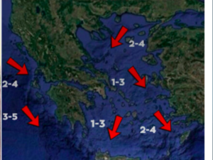





Exceptionally high rainfall totals are forecast for parts of eastern and southern Greece over the coming three-day period, from Monday, October 26, through Thursday, October 29. According to the latest forecast data from the three numerical weather models GFS, ECMWF, and ICON-EU, some areas could receive, within approximately 65 to 72 hours, amounts of rain equivalent to the average rainfall of two, three, or even four Octobers.
The greatest concern is focused on Evia and the Dodecanese, while significant rainfall is also expected in parts of eastern Central Greece, Magnesia, and Attica.
Evia: The strongest forecast signal
Evia is at the center of the heavy rainfall forecast, as all three weather models agree that very high rainfall totals are likely, particularly in the central and northern parts of the island and the wider area around Chalkida.
Estimated rainfall totals range from 120 to 200 millimeters in several areas, while the GFS model locally shows maximum amounts reaching 240 millimeters. The other two models also indicate a similarly strong signal, although they differ in the precise location and intensity of the heaviest rainfall.
To put these amounts into perspective, Chalkida receives an average of approximately 35 millimeters of rain over the entire month of October. If totals of 80 to 150 millimeters are recorded in the wider area, this would be equivalent to the rainfall of approximately two to four average Octobers.
In central and eastern Evia, using Kymi as an illustrative climatic reference point, where average October rainfall is approximately 95 millimeters, totals of 120 to 200 millimeters would correspond to roughly one to two months’ worth of rainfall. If local totals reach 240 millimeters, the equivalent would rise to around two and a half months’ worth.
Dodecanese: Large volumes of rain around Kos and Rhodes
The second area expected to experience particularly high accumulated rainfall is the Dodecanese, especially Kos, Rhodes, and the surrounding sea areas.
For Kos, estimated totals of 100 to 180 millimeters would correspond to approximately two to three average Octobers, given that the island’s average rainfall for the month is about 57 millimeters.
On Rhodes, totals of 60 to 120 millimeters would be equivalent to approximately one to two average Octobers, based on an indicative climatic average of 64 millimeters. However, some forecast scenarios show even higher local totals, potentially exceeding 200 millimeters in the wider area.
These maximum figures should nevertheless be interpreted with particular caution, since a significant proportion of the heaviest rainfall is forecast over the sea and near the coast of Asia Minor.
Magnesia and eastern Central Greece
Significant rainfall is also expected in Magnesia, Larissa, Boeotia, and parts of eastern Central Greece. In the Volos area, indicative total rainfall estimates range from 40 to 80 millimeters.
Given that average October rainfall in Volos is approximately 58 millimeters, the expected amounts correspond to around 70% to 140% of the average monthly rainfall.
What is specifically forecast for Attica?
Attica is of particular interest, as the three forecast models show substantial differences in both the expected rainfall amounts and their geographical distribution.
According to the maps in question, the heaviest rainfall appears likely to shift toward the northern and eastern parts of the region, particularly the wider areas of Oropos, Kapandriti, Marathon, and northeastern Attica.
In these areas, some forecast scenarios indicate accumulated rainfall of 40 to 80 millimeters, while locally higher totals cannot be ruled out if the wetter scenarios materialize.
For the Athens metropolitan basin, uncertainty is greater. The GFS model is generally more conservative, showing rainfall totals of around 10 to 30 millimeters in several areas. By contrast, ECMWF and ICON-EU forecast higher totals in some locations, potentially reaching 40 to 60 millimeters or even more in certain areas.
The forecast signal is generally weaker in western and southwestern Attica, although this does not rule out brief periods of intense rainfall.
It is worth noting that average October rainfall in central Athens is approximately 38 to 40 millimeters, while in Spata it is around 42 millimeters.
This means that if 40 to 60 millimeters of rain falls across the Athens metropolitan basin over the three-day period, the total would be equivalent to approximately one to one and a half average Octobers. In the northern and eastern suburbs, if rainfall reaches 80 millimeters, the amount would approach the rainfall of two average Octobers, using the climatic averages for the wider Athens area as an indicative benchmark.
However, this comparison should not be generalized to the entire region of Attica, as average rainfall varies considerably from one area to another and is influenced by the terrain.
The most important point for Attica is that even rainfall totals lower than those forecast for Evia can cause localized problems if the rain falls at a high intensity, particularly in areas with substantial urban runoff, limited drainage capacity, and already strained streams.
The critical hours of the severe weather
Monday, October 26: Heavy rain and thunderstorms are expected in Evia and the Sporades, while conditions in Magnesia and Larissa will remain unsettled until the evening. In Phthiotis and Boeotia, heavy rainfall is forecast to continue until late afternoon. Conditions will be particularly severe in the Dodecanese, where a red warning is in effect until late in the evening. In Attica, the weather is expected to intensify again during the evening.
Tuesday, October 27: Heavy rain and thunderstorms will continue in Evia and the Sporades until midday, with a fresh deterioration expected from the evening onward. Severe weather will also return to Magnesia and Larissa during the evening. In Phthiotis and Boeotia, another intensification is forecast from late at night, while strong thunderstorms are expected in the Dodecanese from late afternoon. In Attica, severe weather will persist through the morning hours.
Wednesday, October 28: The day of Greece’s national anniversary appears particularly critical for several parts of the country. A red warning is in effect for Magnesia and Larissa, where severe weather is forecast to continue until late at night, as well as for Evia and the Sporades until late in the evening. The Dodecanese is also under the same level of warning. In Phthiotis and Boeotia, rainfall is expected to intensify intermittently until late at night.
Particular caution in Attica and during the parades
Two additional critical periods have been identified for Attica. The first begins on Monday evening and continues through the morning hours of Tuesday, October 27.
The second extends from the early hours of Wednesday, October 28, until midday on the same day.
This means that the morning of Greece’s national anniversary, when school parades take place, coincides with a period in which the likelihood of severe weather is elevated.
Particular caution is therefore needed, especially in areas where rainfall may be exceptionally intense. The precise intensity and geographical distribution of the thunderstorms will largely determine whether localized flooding occurs.
The development of the severe weather system requires continuous monitoring, as even small shifts in the bands of heavy rainfall could significantly change the amount of water received by each area.
Ask me anything
Explore related questions