




Sunday, 15 November, will bring falling temperatures, increased cloud cover and localised rainfall across several parts of Greece, while a further change in weather conditions is expected from the afternoon, particularly in western areas during the evening. Rain will initially affect Macedonia, Thrace, Thessaly, Evia and parts of eastern Central Greece, before spreading to the northern Ionian Sea, Epirus and western Central Greece, where thunderstorms are also possible.
Meanwhile, northerly winds in the Aegean will locally reach Force 6 on the Beaufort scale during the morning, while temperatures will fall noticeably, particularly in northern Greece, where maximum values will be limited to 15-17°C.
Where will it rain today and when are thunderstorms expected?
According to the latest forecast data, the day will begin with intermittently increased cloud cover across eastern and northern mainland Greece, where localised rainfall is expected. The rain will mainly affect Macedonia, Thrace, Thessaly, Evia and parts of central and eastern Central Greece.
Isolated thunderstorms are possible in northeastern Greece during the morning, while conditions are expected to improve gradually throughout the day, with the rain becoming less widespread and some brighter intervals developing.
Elsewhere, temporary cloud cover will prevail, becoming thicker in places around midday and during the afternoon, particularly over mainland areas, with a chance of occasional light rain.
The most significant change is expected towards the evening, when an atmospheric disturbance approaching from the west will bring increasing cloud cover and rainfall to the northern Ionian Sea, Epirus and western Central Greece.
The rain may be accompanied by isolated thunderstorms, particularly around Corfu and the northwestern maritime areas. Rain is also expected in parts of Aetolia-Acarnania.
Visibility will also be locally reduced during the morning in western Greece.
Temperatures fall to 15°C in northern Greece
Temperatures will decline, with the drop most noticeable in northern and central Greece due to prevailing northerly and northeasterly winds.
In Macedonia and Thrace, maximum temperatures will generally reach 15-17°C, although some areas of northern Greece may record even lower daytime highs.
In central Greece, maximum temperatures will range from approximately 18°C to 22°C, while southern and island regions will remain relatively warmer, with temperatures locally reaching 23-24°C.
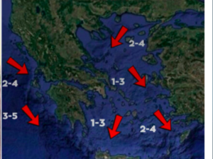
In the Ionian Sea, winds will blow from southerly directions at Force 3-4, gradually strengthening to Force 5 in places. In the Aegean, northerly and northeasterly winds will reach Force 4-5, locally increasing to Force 6 during the morning.
Weather in Athens and Attica
Attica will experience intermittent cloud cover with sunny intervals, although clouds will occasionally become thicker, particularly in the northern and eastern parts of the region.
There is a slight chance of light localised rainfall, mainly in northern areas, although widespread rain is not expected.
Winds will blow from northerly directions at Force 3-4, becoming locally stronger in eastern and coastal areas.
Temperatures will range from approximately 12°C to 20°C, with the cooler conditions becoming more noticeable during the evening.
Weather in Thessaloniki
Thessaloniki will see increased cloud cover, particularly during the morning, with localised or light intermittent rainfall.
From midday onwards, the rain is expected to ease, although some showers may briefly persist in mountainous parts of the region.
Winds will blow mainly from easterly and southeasterly directions, generally remaining light to moderate.
Temperatures will fall noticeably, ranging from approximately 7°C to 15°C.
Detailed forecast for the rest of Greece
Macedonia and Thrace: Intermittently increased cloud cover, with localised rainfall mainly during the morning and a chance of isolated thunderstorms in northeastern areas. Conditions will gradually improve throughout the day. Temperatures will reach 15-17°C.
Ionian Islands and Epirus: Initially intermittent cloud cover with sunny intervals. Clouds will increase from the afternoon, with rain expected during the evening and a chance of thunderstorms, particularly in the northern Ionian Sea and around Corfu. Southerly winds will reach Force 3-5.
Thessaly: Periods of increased cloud cover, with localised rainfall mainly during the morning. Rain will ease later in the day. Temperatures will reach approximately 18°C.
Central Greece and Evia: Intermittent cloud cover with localised rainfall, mainly in eastern areas and Evia. Western Central Greece will see a renewed increase in cloud cover during the evening, with rain and a chance of isolated thunderstorms.
Peloponnese: Some cloud cover, becoming thicker at times, particularly around midday and during the afternoon, with a chance of brief localised showers. Temperatures will reach 21-23°C.
Cyclades and Crete: Generally fair weather with sunny intervals and occasional cloud cover. There is a slight chance of light rainfall in the Cyclades. Northerly winds will reach Force 4-5, while temperatures will remain between 21°C and 24°C.
Eastern Aegean Islands and Dodecanese: Intermittent cloud cover, with possible localised rainfall mainly on the northernmost islands. The Dodecanese will enjoy longer sunny intervals, with temperatures locally reaching 23°C.
Weather forecast for Monday, 16 November
Unsettled weather conditions are expected to persist on Monday, mainly in western and northern Greece, where periods of increased cloud cover and localised rainfall are forecast.
Most of the rain will affect western areas, where isolated thunderstorms are also possible.
Elsewhere, conditions will generally be fair, with scattered clouds becoming thicker at times, while visibility will be locally reduced during the morning and evening.
Winds will gradually turn southerly at Force 3-5, except in the southeastern Aegean, where northerly to northwesterly winds will persist.
Temperatures are not expected to change significantly, with maximum values reaching 16-18°C in northern Greece and 19-23°C elsewhere.
The outlook for the following days indicates a gradual shift towards southerly winds and a possible rise in temperatures, particularly from the middle of the week.
Ask me anything
Explore related questions