
A change in the weather is expected from Sunday night, with rain occurring in most parts of the country. Attica will not be left out, as phenomena are expected during the two-day period Monday–Tuesday, although meteorologists predict they will not be as strong as those recorded on Wednesday (21/1).
According to Christina Rigou, the weather will deteriorate from Sunday night (25/1), with most regions of the country affected during Monday–Tuesday (26–27/1). Gale-force southerly winds are forecast, reaching 8 to 9 Beaufort in the Aegean.
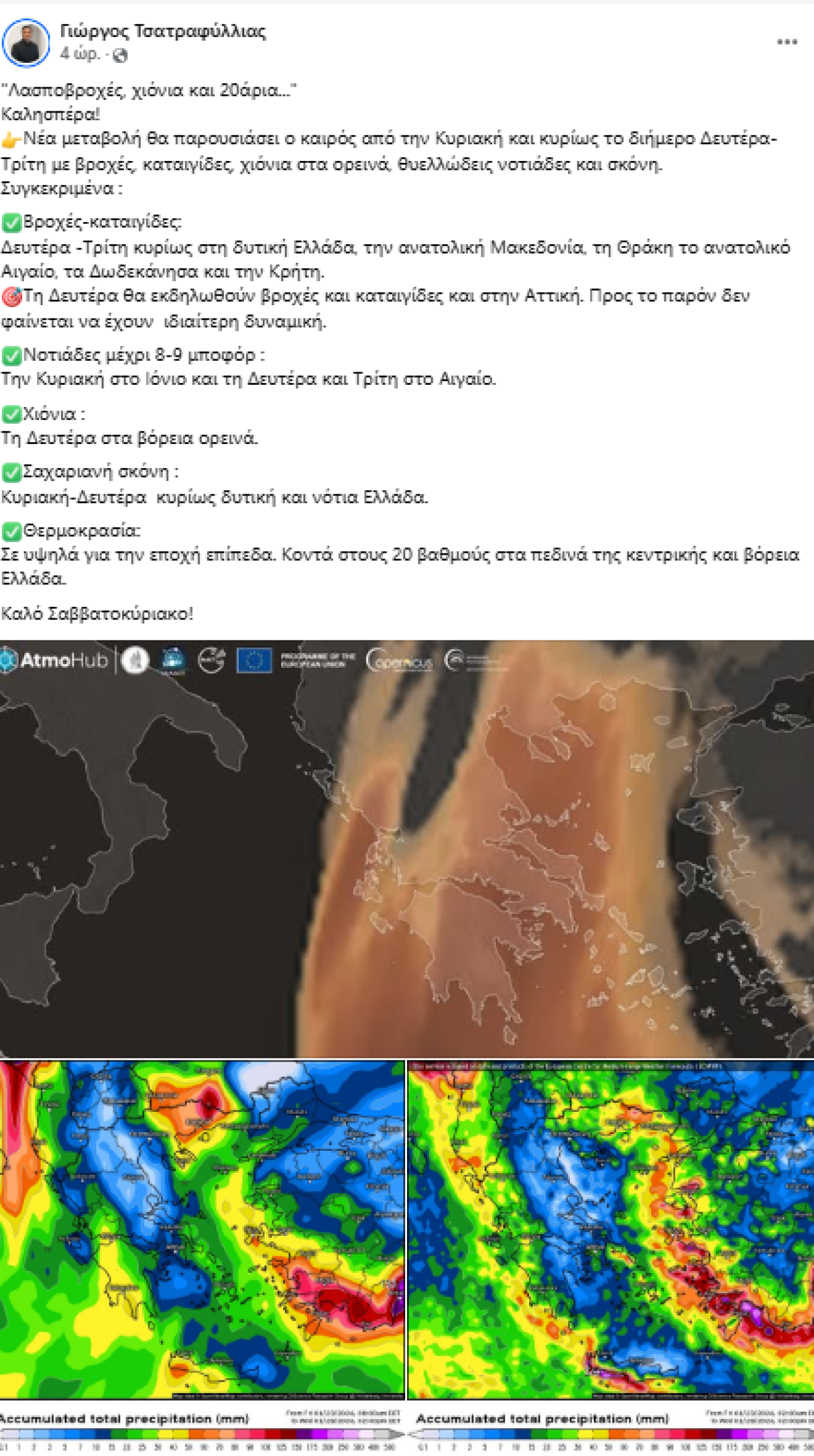
According to the meteorologist, the highest rainfall totals will be recorded in the Ionian Islands, Aetolia-Acarnania, Epirus, Macedonia, Thrace, and across the eastern Aegean, through Tuesday afternoon.
In the rest of the country, including Attica, Thessaly, and the central and southern Aegean, thunderstorms will occur but will not be particularly intense. As Christina Rigou predicts, Athens will experience a rainy Monday–Tuesday, with thunderstorms on Monday crossing the entire Athens basin from east to west.
“Muddy rain, snow and temperatures around 20°C”
Meteorologist Giorgos Tsatrafyllias forecasts muddy rain and a rise in temperatures in the coming days. According to him, the weather will change again from Sunday, especially during Monday–Tuesday, with rain, thunderstorms, snow in mountainous areas, gale-force southerly winds and dust.
Rain and thunderstorms are expected on Monday and Tuesday “mainly in western Greece, eastern Macedonia, Thrace, the eastern Aegean, the Dodecanese and Crete.” Attica is expected to be affected on Monday with rain and thunderstorms which, for the time being, do not appear to have significant intensity, according to the meteorologist.
Southerly winds will reach 8–9 Beaufort on Sunday in the Ionian Sea and during Monday–Tuesday in the Aegean, while snowfall will occur at the beginning of the week in northern mountainous areas.
As for African dust, according to the meteorologist, it will make its appearance during Sunday–Monday mainly in western and southern Greece. Finally, temperatures will remain high for the season, reaching close to 20°C in the lowlands of central and northern Greece.
EMY forecast for Saturday, January 24
In western regions and the eastern Aegean, increased cloudiness with local rain, and in the Dodecanese isolated thunderstorms early in the day. In the rest of the country, generally fair weather with temporarily increased cloud cover.
Visibility will be locally limited over the mainland during the morning and evening hours, with fog formation.
Winds will blow from southerly to southwesterly directions at 3–5 Beaufort, strengthening at night in the Ionian Sea.
Temperatures will not change significantly, reaching 14°C in the north, 15–17°C in the rest of the mainland, and 18–19°C in the island regions.
In detail:
ATTICA
Weather: Mostly fair with temporarily increased cloud cover.
Visibility locally limited in the morning and evening.
Winds: Southerly 3–4 Beaufort.
Temperature: From 7 to 16°C.
THESSALONIKI
Weather: Mostly fair with temporarily increased cloud cover. Visibility locally limited in the morning, with fog patches.
Winds: Variable 2–3 Beaufort.
Temperature: From 5 to 12°C.
MACEDONIA, THRACE
Weather: Temporarily increased cloud cover. In the evening, local rain in western Macedonia.
Winds: Variable 2–4 Beaufort.
Temperature: From 2 to 14°C, with maximum temperatures 3–4 degrees lower in western Macedonia.
IONIAN ISLANDS, EPIRUS, WESTERN CENTRAL GREECE, WESTERN PELOPONNESE
Weather: Cloudy at times with local rain.
Winds: Southerly 3–4 Beaufort, locally 5 Beaufort in the Ionian, strengthening at night.
Temperature: From 7 to 17°C. In inland Epirus, 3–5 degrees lower.
THESSALY, EASTERN CENTRAL GREECE, EUBOEA, EASTERN PELOPONNESE
Weather: Mostly fair with temporarily increased cloud cover.
Winds: Southerly–southwesterly 3–4 Beaufort, locally 5 Beaufort from the afternoon.
Temperature: From 3 to 17°C, with maxima 2–3 degrees lower in the north.
CYCLADES, CRETE
Weather: Mostly fair with temporarily increased cloud cover.
Winds: Southerly–southwesterly 3–4 Beaufort, locally 5 Beaufort from the afternoon.
Temperature: From 12 to 19°C.
EASTERN AEGEAN ISLANDS – DODECANESE
Weather: Periodically cloudy with local rain and, early in the day in the Dodecanese, isolated thunderstorms.
Winds: Southerly–southwesterly 3–4 Beaufort, locally 5 Beaufort from the afternoon.
Temperature: From 12 to 19°C, with maxima 2–3 degrees lower in the north.
Weather on Sunday, January 25
In western and northern regions, the eastern Aegean islands and the Dodecanese, temporarily increased cloudiness with local rain mainly in the north and east. From the evening, cloud cover will increase in the west, with local rain in the Ionian Sea and possibly isolated thunderstorms in the northern Ionian. In the rest of the country, mostly fair weather with cloud cover increasing after midday.
Winds will blow from southerly directions: 5–7 Beaufort in the west and, from the afternoon, 7–8 Beaufort in the Ionian; 4–6 Beaufort in the east, strengthening to 5–7 Beaufort in the afternoon. Temperatures will rise, reaching 16–17°C in the north, 18–19°C in the rest of the mainland, and 19–20°C in western and island regions.
Forecast for Monday, January 26
Cloudy conditions with local rain and scattered thunderstorms across most of the country. Phenomena in the west, north and eastern Aegean may be locally intense. Snowfall is expected in the mountainous areas of western and northern Greece. Winds in the west will be west to southwesterly at 4–6 Beaufort. In the east, southerly winds at 5–7 Beaufort, locally up to 8 Beaufort in the Aegean, gradually weakening. Temperatures will drop in terms of maximum values in central and northern regions.
Weather on Tuesday, January 27
In eastern mainland areas, the eastern Aegean, the Cyclades and Crete, increased cloudiness with rain and scattered thunderstorms. In the rest of the country, generally fair weather with intervals of increased cloud cover and a few scattered showers. Light snowfall is expected in mountainous mainland areas.
Winds will blow northwesterly at 4–6 Beaufort in the west, and southerly at 4–6 Beaufort in the east, locally up to 7 Beaufort in the south, gradually shifting after midday to west–northwesterly at 4–6 Beaufort. Temperatures will see a slight drop in the east.
Forecast for Wednesday, January 28
In the eastern Aegean islands and the Dodecanese, cloudy with local rain and isolated thunderstorms in the Dodecanese, gradually weakening. In the rest of the country, mostly fair weather, with cloud cover increasing gradually in the west and local rain after midday.
Winds will blow from southerly directions at 4–6 Beaufort in the west and west–southwesterly at 4–5 Beaufort in the east. Temperatures will show a slight rise in the west.
Ask me anything
Explore related questions


