
Unsettled weather is expected today, Thursday, according to the forecast of the Hellenic National Meteorological Service, with local rains in the Ionian Sea, Epirus, western Central Greece and the western Peloponnese, while from the evening, sporadic thunderstorms will also occur in the north. Snowfall is expected from the evening in the mountainous areas of Epirus, while the bad weather system will affect a large part of the country in the coming days.
Where rain and storms will occur today
Specifically, in the Ionian Sea, Epirus, western Central Greece and the western Peloponnese, a few clouds are expected that will quickly increase, bringing local rain.
From the evening, sporadic thunderstorms are forecast in northern areas, while snowfall will occur in the mountainous regions of Epirus.
Kallianos: A typical late-March weather change
In a post, meteorologist Giannis Kallianos notes that the change in weather from Friday morning, initially from the northwest, is a completely typical development for the last third of March.
As he points out, thunderstorms will mainly occur in western and northern regions and in the eastern Aegean islands, without cause for concern.
For Attica, he states that rainfall will be local and generally weak; however, around midday on Friday there is a possibility of temporary thunderstorms.
It is also clarified that snowfall on Friday will be limited to mountainous areas at altitudes above 900 to 1,200 meters.
Arnaoutoglou: More rain until early April
Sakis Arnaoutoglou reports that a new wave of bad weather will affect the country from Thursday evening, with more rainfall beginning from the west.
On Friday, the phenomena will spread across the entire country and after midday are expected to also affect Attica, with the possibility of locally intense rainfall.
At the same time, heavy snowfall is expected at altitudes above 1,200 meters.
Marousakis: Organized bad weather over the weekend
According to meteorologist Klearchos Marousakis, the weather will start off mild on Thursday, but from Friday and into the weekend, a more organized wave of bad weather will affect many regions of the country.
The phenomena will be accompanied by heavy rainfall and dense snowfall in the mountainous areas of central and northern Greece.
March is expected to end with alternating weather conditions, while unstable weather is also forecast for the first days of April.
Improvement is expected after Holy Tuesday and Holy Wednesday, when a change in atmospheric circulation and a rise in temperature are anticipated.
Holy Week is expected to begin with unstable weather conditions, with the phenomena gradually subsiding, although more intense bad weather is expected on Friday afternoon.
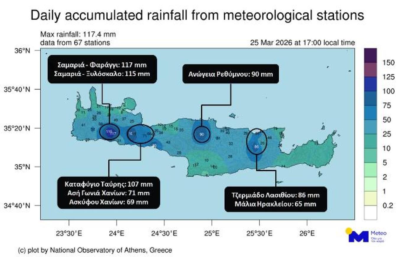
Heavy rainfall in Crete on Wednesday
In line with forecast data from the National Observatory of Athens / Meteo.gr, locally heavy rainfall occurred on Wednesday, March 25, 2026, in Crete.
The map shows the geographical distribution of daily rainfall totals in Crete up to 17:00, as recorded by 67 weather stations of the Observatory’s automatic network.
Today’s weather
Initially, improved weather will prevail across the country, with a few local clouds and locally limited visibility over mainland areas. Gradually, cloud cover will increase in the west and north.
In the afternoon, local rain will occur in the Ionian Islands and western mainland regions, while in the evening the phenomena will intensify in the northern Ionian and Epirus. During the night into Friday, thunderstorms will occur in western areas.
Temperature will range:
- Western Macedonia: -2 to 16–17°C
- Rest of northern Greece: 1 to 17–19°C
- Epirus: 2 to 17–19°C
- Thessaly: 3 to 19–22°C
- Other mainland areas: 4 to 18–21°C
- Ionian islands: 6 to 16–17°C
- Aegean islands and Crete: 6 to 18–20°C
Winds in the central and northern Aegean will be southerly at 4–5 Beaufort. In the southern Aegean, northwesterly winds at 5–6 Beaufort will gradually turn southwesterly. In the Ionian, winds will initially be southwesterly up to 5 Beaufort, later strengthening to 6 and locally 7 Beaufort.
In Attica, a few clouds are expected. Winds will be southwesterly at 3–4 Beaufort, locally 5 in the east. Temperature will range from 10 to 18°C.
In Thessaloniki, a few clouds will increase in the afternoon. Winds will be southeasterly at 3–4 Beaufort, with temperatures between 8 and 18°C.
Weather on Friday (27/03/2026)
Clouds, at times dense, with local rain across most of the country. Sporadic thunderstorms in the Ionian, western and northern mainland, gradually spreading to the eastern Aegean islands and the Dodecanese, and temporarily to the Cyclades and Crete.
By evening, weather will improve in western Macedonia, Thessaly, the Sporades, Evia, eastern Central Greece, and eastern Peloponnese.
Snowfall will occur in mountainous mainland areas.
Winds: west-southwesterly 4–6 Beaufort, locally up to 7 in central and southern seas.
Temperature will drop, especially in the west and north.
Weather on Saturday (28/03/2026)
In the west, south, and eastern Aegean: clouds with local rain and occasional isolated storms, mainly in coastal areas.
Elsewhere: partly cloudy with local showers in the afternoon.
Snowfall in mountainous mainland areas.
Weather on Sunday (29/03/2026)
Partly cloudy with local rain and isolated storms in the Ionian, Crete, and eastern Aegean. Afternoon showers inland.
By evening, weather improves in most areas, with phenomena limited to eastern Macedonia, Thrace, eastern Aegean, and Crete.
Light snowfall in mountainous mainland areas.
Winds: west-northwesterly 3–5 Beaufort, locally up to 6–7.
Temperature: no significant change.
Ask me anything
Explore related questions


