





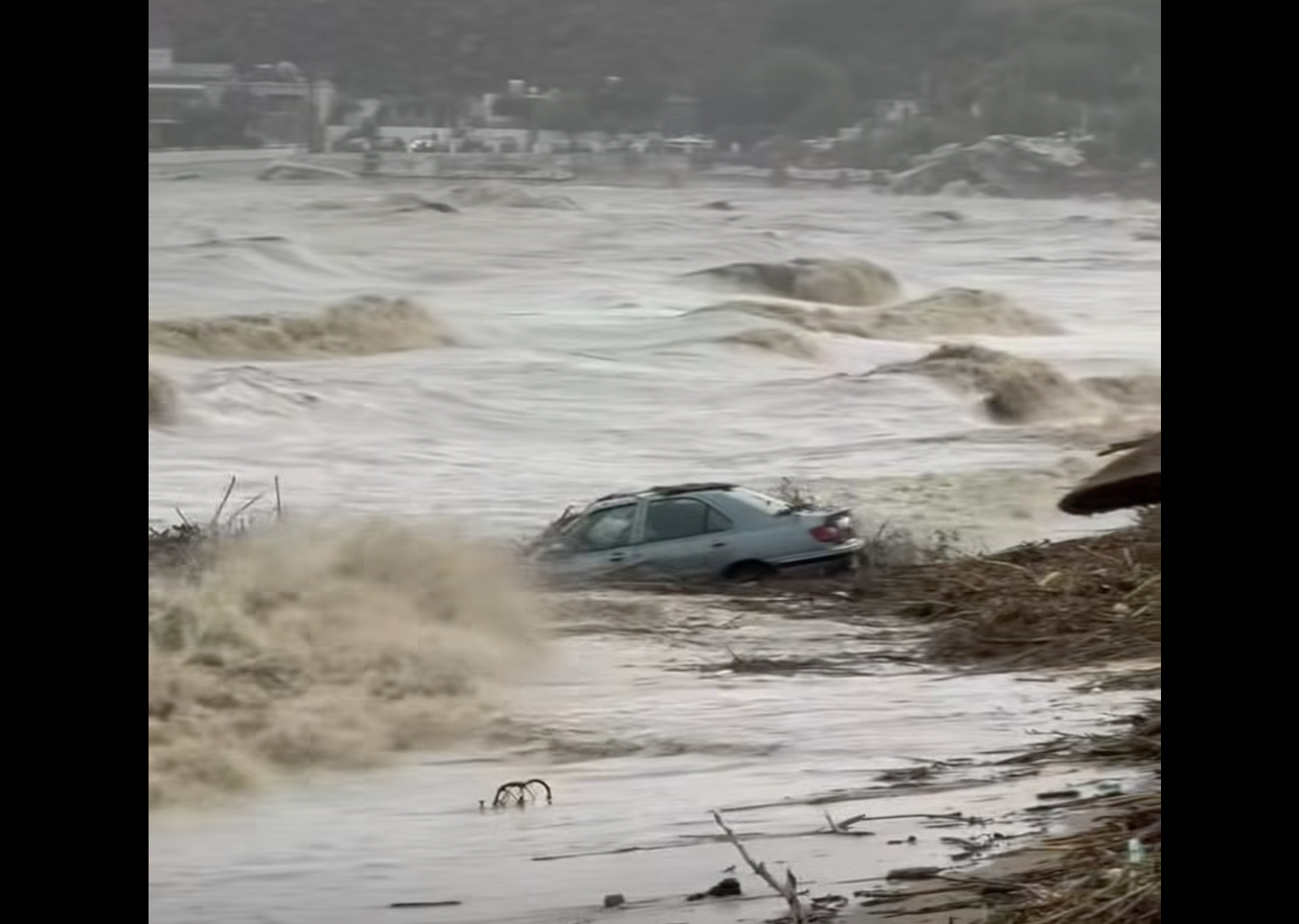
A 62-year-old man has died on the Greek island of Rhodes after the car he was in was swept into the sea by floodwaters during a severe storm. His body was recovered by the Hellenic Coast Guard off Stegna beach, near Archangelos.
According to reports, the victim, a hotel employee, had gone to collect his car from the area when he was caught in the fast-flowing floodwaters. A total of four vehicles were swept into the sea, while an emergency alert was issued through Greece’s 112 warning system at 10.44am, urging residents across the island to limit their movements.
Coast Guard statement
The Hellenic Coast Guard confirmed that a person had been found unconscious in the waters off Stegna, Rhodes, where four cars had been washed into the sea as a result of the extreme weather conditions.
Coast Guard officers were deployed to the scene in a patrol vehicle, alongside police officers and an ambulance from the National Emergency Aid Centre (EKAB), while a fire service vehicle was also on its way.
Μεγάλες καταστροφές στην #Ρόδο από την ισχυρή #κακοκαιρία . Βίντεο : Giorgos despotakis https://t.co/JF9Xqbjohx
— Forecast Weather Greece (@ForecastGreece) October 14, 2026
Flooded roads and widespread disruption across Rhodes
Severe weather has caused major disruption to roads and transport services across Rhodes since the early hours of Wednesday, with civil protection teams from the municipality and the South Aegean regional authorities responding to incidents across the island.
Stegna beach has effectively been split in two by a torrent flowing down from Archangelos towards the small harbour at Reni.
Supply deliveries have also been disrupted, along with tourist arrivals and departures. Residents were earlier urged through the 112 emergency alert system to restrict their movements and follow instructions from the authorities. Rhodes Mayor Alexandros Koliadis also issued a similar appeal.
Torrential rain has turned roads into rivers between Ialysos and Rhodes town, as well as in Afandou, Faliraki and Archangelos, leaving dozens of vehicles stranded. In Archangelos, an unoccupied car was swept away by a raging torrent. Traffic was suspended on the Archangelos–Malona road in the Aithonas area after a large boulder fell onto the road, damaging the surface and safety barriers.
The bridge connecting the main road to the settlement of Archangelos was also temporarily closed as a precaution. In Ialysos, a lightning strike sparked a fire at a house, although no other serious consequences have been reported so far. Another lightning strike knocked out the electrical system at ERT South Aegean, interrupting the public broadcaster’s transmissions. A double waterspout was also spotted off Archangelos, with no problems reported.
Δραματικές εικόνες στο νησί της Ρόδου παρασύρονται αυτοκίνητα στην θάλασσα. Βίντεο : Axantek https://t.co/YzL3t1cTO5
— Forecast Weather Greece (@ForecastGreece) October 14, 2026
Municipal bus services were temporarily suspended within Rhodes town, on routes to and from the port of Akandia, and on the Rhodes–Faliraki route. Schools remain closed today on Rhodes and the neighbouring island of Symi, while municipal sports facilities, the municipal conservatory and municipal workshops on Rhodes are also shut.
From 12.30pm, the archaeological sites of Lindos, Kamiros and the Acropolis of Ialysos-Filerimos, along with the Archaeological Museum of Rhodes and the Palace of the Grand Master, were closed to protect visitors and staff. A scheduled meeting of Rhodes municipal council was also cancelled.
Severe weather expected to continue in eastern and southern Greece
Although conditions are easing across much of Greece, heavy rain and thunderstorms are expected to continue until Wednesday evening, particularly in eastern and southern parts of the country, according to the Civil Protection Minister. Very strong northerly and northeasterly winds of up to force 9 on the Beaufort scale are also expected to persist across the Aegean, the Risk Assessment Committee said.
The committee met on Wednesday, 14 October, chaired by Civil Protection Secretary-General Nikos Papaefstathiou and attended by Climate Crisis and Civil Protection Minister Evangelos Tournas, to assess the developing weather conditions and the outlook for the coming hours.
Experts warned that the most severe conditions were expected in Evia, the Sporades islands, Magnesia, Crete and the Dodecanese, while gale-force winds across the Aegean would continue until late at night.
Seven areas placed on red alert
Seven areas of Greece remain under the highest-level Red Code emergency mobilisation alert until the end of Wednesday. These are:
- The Evia regional unit
- The Sporades regional unit
- The Attica region
- The South Aegean region
- The Crete region
- The Samos and Ikaria regional units
- The Peloponnese region
The National Coordination Centre for Operations and Crisis Management remains in constant contact with municipalities, regional authorities and other relevant agencies to ensure emergency preparedness and coordinate the response to the storms.
Fallen trees and emergency alerts
Civil Protection Minister Tournas said several incidents had been reported overnight, mainly involving gale-force winds and fallen trees. Emergency teams responded in coordination with the National Coordination Centre for Operations and Crisis Management and local authorities.
Emergency warnings were issued through the 112 alert system wherever necessary, advising residents to restrict travel. Fire crews continue to respond to incidents, while the operational plan for tackling flooding and related hazards remains in effect.
Authorities are closely monitoring weather developments and continuously assessing conditions to determine what further action may be required in affected areas.
Weather warning downgraded from red to orange
The Hellenic National Meteorological Service has updated its emergency severe weather bulletin, numbered 7/2026 and originally issued on Tuesday, 13 October, downgrading the warning from red to orange following the latest forecast data.
Heavy rain and thunderstorms are still expected on Wednesday, 14 October, mainly in coastal and offshore areas of the Aegean, alongside locally severe northeasterly winds.
The revised forecast warns of heavy rainfall and thunderstorms in Evia until late afternoon, the Sporades and eastern Thessaly, particularly Magnesia, until the afternoon, the Dodecanese until the evening, and Crete, especially Chania and Rethymno, until late at night.
Very strong northerly and northeasterly winds of force 8 to 9 are expected across the Aegean until late Wednesday night.
Flooding and fallen trees as evacuation ordered in Evia
The Fire Service Operations Centre received 58 calls from Attica and Evia between Tuesday and 6am on Wednesday following heavy rainfall and strong winds.
In Attica, firefighters received 38 calls, carried out nine water-pumping operations and removed 15 fallen trees. In Evia, they responded to 20 calls, removed 19 trees and carried out one road-cleaning operation.
Shortly before 12.30pm, residents in the Makrykapa area of Evia received an emergency 112 alert ordering them to evacuate towards Psachna following a river overflowing its banks.
⚠️ Έσπασε ο ποταμός στην Μακρυκάπα Εύβοιας ⚠️ Προσοχή σε όλους, απομακρυνθείτε προς ασφαλή σημεία και ακολουθήστε τις οδηγίες των αρχών. Βίντεο : Sterea economy https://t.co/0cd1tOwbex
— Forecast Weather Greece (@ForecastGreece) October 14, 2026
An earlier alert was also sent to people in Politika, Evia, warning them to take care when travelling because of the severe weather. The message read: “Severe weather conditions in the Politika area of Evia. Exercise caution when travelling. Follow the instructions of the authorities.”
According to local media, the overflowing of the Kireas River has caused serious disruption to road links between northern Evia and Chalkida.
Storm damage on Skiathos
Storms sweeping across the northern Sporades over the past 24 hours have also caused damage on Skiathos. The 112 emergency alert system was activated twice, while the island’s mayor, Thodoris Tzoumas, told the Athens-Macedonian News Agency (AMNA) that a request had been submitted for the municipality to be declared in a state of emergency.
“The rain and winds are continuing. We are carrying out repairs to the main road network, where debris has accumulated. We have had some fallen trees and two cars have been swept away, while schools are closed. The storm appears to be easing,” Tzoumas said.
He added that between 40 and 50 businesses and 15 to 20 homes had suffered damage. The process of arranging compensation and carrying out damage assessments has begun, with inspection teams from the Thessaly regional authorities and the Ministry of Climate Crisis and Civil Protection expected to carry out the necessary checks.
Sailing boat runs aground near Alonnisos
A Greek-flagged sailing boat carrying two people ran aground off the island of Peristera, near Alonnisos.
According to the Hellenic Coast Guard, both passengers were rescued by a private vessel carrying Coast Guard personnel and taken to the port of Alonnisos.
Northeasterly winds of force 8 on the Beaufort scale were blowing in the area at the time.
Ferry departures suspended from Piraeus and Lavrio
Gale-force winds across the Aegean continue to disrupt ferry services, with a sailing ban remaining in force at the ports of Piraeus and Lavrio until 3pm on Wednesday.
According to the Hellenic National Meteorological Service, winds are reaching force 9 and temporarily force 10 in some areas.
The Coast Guard said only certain conventional passenger and vehicle ferries were operating in the Saronic Gulf, while hydrofoil services had been suspended. Ferry services between Paloukia on Salamina and Kamatero in Piraeus have also been halted.
Three morning ferry services departed normally from Rafina, while conditions are due to be reassessed after 4pm to determine whether later sailings can operate.
Other ferry connections have also been affected by the adverse weather, with services suspended on the Prinos–Kavala, Agia Marina–Nea Styra and Arkitsa–Aidipsos routes.
Passengers planning to travel on Wednesday are advised to contact local port authorities and travel agencies in advance for information about potential changes, delays or cancellations.
Ask me anything
Explore related questions




