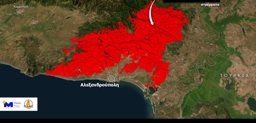
An area of more than 826,000 hectares had been burnt by the fire in Evros by 28/8 based on the latest high-resolution images of the Sentinel-2 environmental satellite, analysed by the mapping service of the National Forest Fire Observatory (EpaDAP), which is implemented by the Laboratory of Forest Management and Remote Sensing of the Department of Forestry and Natural Environment of the Aristotle University of Thessaloniki.
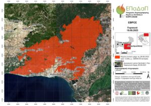
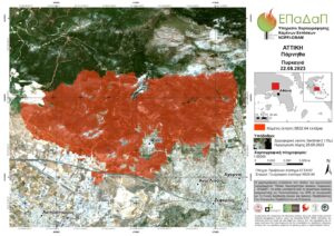
In the maps published by Athens News Agency, it is shown that the burnt areas for the areas of Evros and Parnitha Prefecture of Attica until 28/08/2023 amount to 82639.63 and 5832.64 hectares respectively.
It should be noted that the mapping was carried out with Sentinel-2 data (spatial resolution of 10m). The AUTH Laboratory team notes that “active fronts are observed in the Evros region, which is expected to significantly affect the final estimate of the burnt area”, and “a more accurate estimate of this area will follow in the coming days”.
The latest satellite data made available today by the European Commission’s Copernicus rapid mapping service for the largest forest fire in many years on European soil in Evros.
#EMSR686 #Alexandroupolis #Greece🇬🇷
Our #RapidMappingTeam is working on its 6⃣th Delineation Monitoring Product for the historic #wildfire that is ravaging the East Macedonia & Thrace Region using VHR 🛰️ imagery
Updates 🔜 https://t.co/m030JiUPuq
👇”QuickLook” visualisation pic.twitter.com/i9z3rLfig6
— Copernicus EMS (@CopernicusEMS) August 28, 2023