Related Stories


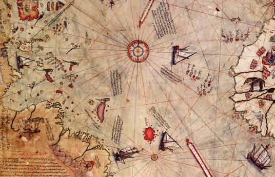
On October 9, 1929, a German theologian named Gustav Adolf Deissmann was cataloguing items in the Topkapi Palace library in Istanbul when he happened across a curious parchment located among some disregarded material. On the gazelle skin parchment was a map, now referred to as the Piri Reis map . The map was drawn and signed by Turkish cartographer Hagji Ahmed Muhiddin Piri , aka Piri Reis, and is dated to 1513 CE. Reis was an admiral in the Turkish navy, an experienced sailor, and a cartographer, who claimed to have used 20 source maps and charts to construct the map, including 8 Ptolemaic maps, 4 Portuguese maps, an Arabic map, and a map by Christopher Columbus.
Since its discovery, the map has stirred both intrigue and controversy, mostly due to the presence of what appears to be a representation of Antarctica 300 years before it was discovered. Another—if not even more intriguing facet of the appearance of Antarctica—is that it appears to show the land mass before it was covered in ice, over 6000 years ago.
The great debate was sparked by Professor Charles Hapgood when he published his theory on the Piri Reis map in his book Maps of the Ancient Sea Kings in 1965. He and a team of students at the University of New Hampshire studied the map and found many anomalies, such as the use of mercatorial projection and the inclusion of a pre-ice Antarctica. The Greeks were able to create cylindrical maps based on their knowledge of a spherical earth, though mercatorial projection was not used by Europeans until later in the 16 th century, and were also able to use astronomy and geometry to calculate latitude and longitude, though absolute accuracy was not possible until the invention of the chronometer in 1760. While these two feats—amazing as they are—could be explained by use of Greek source maps and charts from the age of Alexander, nothing could explain the inclusion of Antarctica. As a result, Hapgood proposed that the map was based on materials that pre-date 4000 BCE, before any known developed languages or progressive civilizations. This theory implies that a prehistoric civilization had the technology to navigate major seaways and fairly accurately chart the globe. Hapgood also suggested that the topographic depiction of the interior of the continents required aerial capabilities, implying the prehistoric ‘super’ civilization to be both nautical and aerial masters and leading to the further speculation of either an Atlantean or alien civilization. No evidence has been found to support such theories.
Read more HERE