Related Stories


The construction by the US of the floating platform to serve as a bridge for transporting humanitarian aid to Gaza has begun. At the same time, Americans fear a possible attack by Hamas on the platform while simultaneously observing Israel building a mysterious road within Gaza.
The support ship, the General Frank S Besson, departed from a military base in the state of Virginia on Saturday. The American vessel set sail “less than 36 hours” after Joe Biden’s announcement. It carried “the first equipment for the creation of a temporary pier for the delivery of vital humanitarian supplies” to Gaza, the announcement continues.
On March 9, 2024, U.S. Army Vessel (USAV) General Frank S. Besson (LSV-1) from the 7th Transportation Brigade (Expeditionary), 3rd Expeditionary Sustainment Command, XVIII Airborne Corps, departed Joint Base Langley-Eustis en route to the Eastern Mediterranean less than 36 hours… pic.twitter.com/X70uttuY9J
— U.S. Central Command (@CENTCOM) March 10, 2024
The Pentagon stated that it may take up to 60 days to construct the pier with the assistance of 1,000 soldiers – none of whom will set foot on land. Charity organizations have declared that those suffering in Gaza cannot wait that long.

The two-lane bridge, approximately half a kilometer long, will lead to a landing area on land and will be secured to the ground by non-American personnel, whom Ryder did not name. Trucks will then have access to the pier to pick up and transport the aid.
Washington is coordinating with other countries in the region, the United Nations, and humanitarian groups to determine how the aid will be distributed once it reaches land, said Lieutenant General Patrick Ryder, Pentagon spokesman. The American personnel will remain either on the bridge or on the ships, he said.
Asked if the Pentagon believes that Hamas fighters will target the American forces operating offshore, Ryder said that this is “certainly possible.” He added that “if Hamas is genuinely interested in the Palestinian people, then…one would hope that this international mission to deliver aid to people in need could proceed unimpeded.”
Sunday afternoon, the first ship was scheduled to depart from Cyprus
Meanwhile, on Sunday afternoon, a vessel carrying a floating platform loaded with humanitarian aid bound for Gaza and depart from the port of Larnaca as part of the “Amalthea” humanitarian corridor.
Information from the Cyprus News Agency indicates that the ship, which was already loaded with approximately 150 tons of humanitarian aid, including food, departed after receiving approval from Israel.
It is noted that it is expected to take up to two days to reach Gaza. The specialized vessel will transport the floating platform “MMS ARIS,” on which the humanitarian aid is loaded.
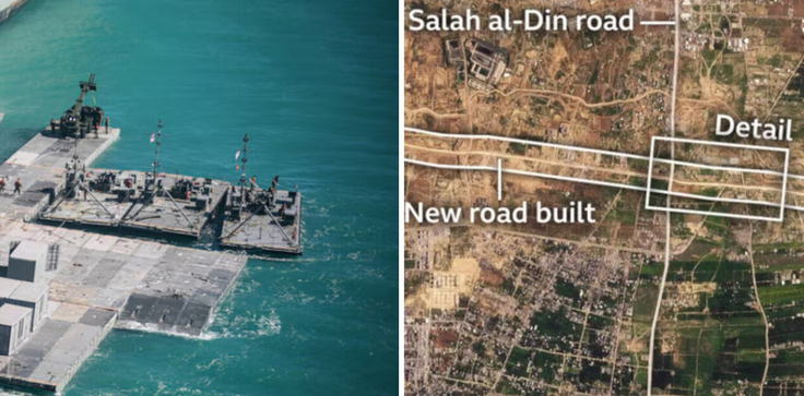
The mysterious road
At the same time, the Israeli Defense Forces (IDF) are completing the construction of a… mysterious road across the width of Gaza, as satellite images show. This road traverses northern Gaza from east to west, according to satellite images verified by the BBC.
The IDF told the BBC that they are seeking “operational leverage” and facilitating the movement of troops and equipment. But some experts fear it will be used as a barrier, preventing Palestinians from returning to their homes in the north. Others said it appears to be part of an Israeli plan to stay in Gaza after the end of hostilities.
In February, Prime Minister Benjamin Netanyahu presented a post-war vision in which Israel would indefinitely control security in Gaza. International leaders have previously warned Israel not to permanently displace Palestinians or reduce the size of Gaza.
The crab boats of Stefanos Kasselakis – Marinakis: Unrelenting questions seeking answers
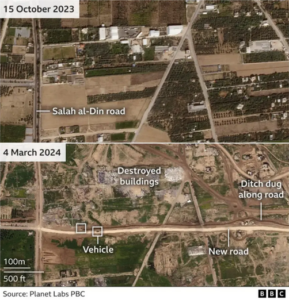
What we know about the road:
It runs through northern Gaza, with central and southern areas being south of it.
It begins from the Gaza-Israel border fence near the Nahal Oz kibbutz and ends near the coast.
It also intersects with Salah al-Din and al-Rashid roads, the two main arteries traversing the area.
Despite an existing network of roads connecting east and west, the new IDF route is the only one continuously crossing Gaza.
Satellite image analysis by the BBC reveals that the IDF has constructed over 5 kilometers (3 miles) of new road sections to link previously unconnected roads.
The new road is wider than a typical Gaza road, except for Salah al-Din.
Image analysis also shows that buildings along the route, which appear to be warehouses, were demolished from late December to late January.
The road extends through an area that historically had fewer buildings and was less densely populated than other parts of Gaza.
It also lies beneath a makeshift and serpentine route previously used by the IDF to move from east to west.
An Israeli television channel mentioned the route in February, saying it was codenamed “Highway 749.” A journalist from Channel 14 traveled along sections of the route with the Israeli army.
How could Highway 749 be used?
Analysts from Janes, a defense information company, stated that the type of unpaved road shown in Channel 14’s video was suitable for tracked armored vehicles.
The IDF did not delve into such details in their announcement. “As part of the ground operation, the IDF is using an operational route of passage,” it said.
Retired Brigadier General Jacob Nagel, former head of Israel’s National Security Council and former security advisor to Mr. Netanyahu, told BBC Arabic that the aim of the new route was to provide quick access to security forces in dealing with new threats.