
The weather landscape in the country is gradually changing from tomorrow, with high for the season temperatures being followed by intense phenomena such as storms and snow. From Friday afternoon onwards, showers and thunderstorms will occur in the western and northwestern parts of the country, while in the evening the phenomena will extend to the rest of mainland Greece. On Saturday, showers and local thunderstorms are expected almost all over the country. There will be snowfall in the mountains and in semi-mountainous areas of western Macedonia.
Snow
Meteorologist George Tsatrafyllias said in his post that “if the current forecast data are maintained, I think that this Christmas we will have snow in the… bell tower”, noting that day by day it will become clear whether snow will fall only in the mountains.
According to his post from this Friday (20/1), we will have a change in the weather and it seems from Monday 23rd of the month and Christmas Day the main features will be a drop in temperature of five to six degrees, the snow, for now, is enough and limited to central and northern Greece and we will see if it will fall at lower altitudes. Also, “We will have showers and thunderstorms in most areas, in the lowlands, and on the islands, while strong winds of 7 to 8 Beaufort will blow,” the meteorologist noted in his post.
Snow even at relatively low altitude
Snow and even relatively low altitudes are expected in some areas on Christmas, according to the latest weather forecast data presented by Sakis Arnaoutoglou.
Next Tuesday, on Christmas Eve, there will be a noticeable drop in temperature in western, central, and northern Greece. Also, “several snowfalls are expected in several areas, mainly in mountainous areas and occasionally at lower altitudes in northern Greece.”
As for Christmas, it will probably be better weather in western Greece: the Ionian Islands, maybe Epirus, western Peloponnese, and western Sterea Greece, according to Sakis Arnaoutoglou.
Sasaki Agronorgos, who is expected to be in the region of Sasaki, will be the first of the new members of the team.
“The rest of the country is experiencing the most Christmas-like weather, with snowfall, rain, maybe thunderstorms in the Aegean Sea,” he added in the weather report he posted on YouTube on Wednesday.
“Snowfall is expected in several relatively low-altitude areas of eastern mainland Greece and perhaps in the north,” he noted. “Almost all ski resorts will work,” Sakis Arnaoutoglou said.
The extent of snow cover in Greece – 16 December 2024
The latest satellite data for snow cover in Greece on 16/12 shows that about 4% of the land area of Greece is covered with snow, which means that the snow cover rate is below the average for the period 2004-2023 for the second 10 days of December. The latest forecast data on Wednesday 18/12 indicates that significant snowfall is expected to occur in the mountains by Christmas and the snow cover area is expected to be close to the average for the 2004-2023 period.
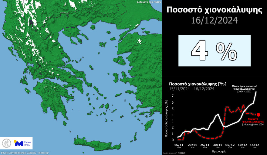
The graph below shows the distribution of snow cover in white on the left and on the right the time series of satellite records this winter (red dotted line) and the corresponding daily averages (white line) calculated from the 2004-2023 data.
Today’s weather
Sunshine is expected with intermittent local clouds. Visibility will be limited in some areas until the morning and again towards the end of the day.
Temperature Ranges:
- Western Macedonia: -2 to 12°C
- Macedonia and Thrace: 0 to 13°C
- Thessaly: 2 to 15°C
- Epirus and Western Central Greece: 2 to 15°C
- Central Greece: 1 to 16°C
- Peloponnese: 0 to 17°C
- Ionian Islands: 7 to 15°C
- North and East Aegean Islands: 3 to 17°C
- Cyclades: 8 to 17°C
- Dodecanese: 6 to 17°C
- Crete: 5 to 18°C
Winds:
- In the North Aegean, winds will initially blow from variable directions at 2–4 Beaufort, shifting to southerly winds of the same intensity in the afternoon.
- In the Central Aegean, winds will start from the north at 2–4 Beaufort, later becoming south-westerly.
- In the South Aegean, winds will shift from northerly to westerly at 2–4 Beaufort.
- In the Ionian Sea, winds will start as variable but will transition to westerly by midday and southwesterly by the afternoon, maintaining 2–4 Beaufort intensity.
Regional Forecasts:
- Attica:
Sunshine with occasional clouds. Winds will shift from variable directions to the southwest at up to 3 Beaufort. Visibility will be locally restricted during early morning and late evening hours. Temperatures will range from 9 to 16°C in central Athens. - Thessaloniki:
Sunshine with occasional clouds. Winds will remain variable at up to 2 Beaufort. Visibility may be locally limited during the early morning and late-night hours. Temperatures in central Thessaloniki will range from 7 to 13°C.
Upcoming Weather:
Friday, 20-12-2024
Clouds will increase across the country, with local rains expected in the west, south, eastern Aegean, and Thrace. By the afternoon, rain and sporadic thunderstorms will spread to most regions, intensifying over the Ionian Sea and western mainland during the evening. Light snow may fall on northern mountainous areas by night. Morning visibility will be reduced in certain inland areas.
Winds will blow west-southwest at 3–5 Beaufort, increasing to 6–8 Beaufort by evening in southern seas. Temperatures will remain steady:
- 13–15°C in the north
- 16–18°C in central areas
- Up to 19°C in southern mainland and islands
Saturday, 21-12-2024
Rain and thunderstorms will affect much of the country. The Ionian Sea, western mainland, Macedonia, Thrace, eastern Aegean islands, Cyclades, and Crete may experience intense weather. Conditions will improve from the afternoon in western regions. Snowfall is expected in the mountains of the west, central, and northern mainland until midday.
Winds will blow southwest at 4–8 Beaufort, later shifting to northwest. Temperatures will drop slightly, particularly in the west and north:
- 12–14°C in northern regions
- 15–18°C elsewhere
- 19°C in southern islands
Sunday, 22-12-2024
Cloudy and unsettled weather with local rain and isolated thunderstorms will persist, mainly in coastal and eastern areas. By evening, precipitation will be confined to the Cyclades, Crete, eastern Aegean islands, and Dodecanese. Frost is expected in some northern inland areas during the morning and night.
Winds will be west-northwest at 4–6 Beaufort, with the southern Aegean experiencing gusts up to 7 Beaufort, which will weaken later. Temperatures will drop across the country.
Monday, 23-12-2024
Rain and thunderstorms will return, especially in the Cyclades, Crete, and eastern Aegean. Clouds will thicken in other regions, bringing localized heavy rain and occasional thunderstorms, especially in the northwest. Snowfall is likely in high-altitude areas in the north.
Winds will come from the west at 4–8 Beaufort. Temperatures will rise slightly in the west and south but remain frosty in northern areas during the morning and night.
Ask me anything
Explore related questions