
Showers are expected today (13/03) with localized phenomena mainly in the west and north, where sporadic thunderstorms of short duration will occur. However, they will stop at noon in most areas.
At the same time, the transport of African dust is favored, as there will be south winds of 7 to 8 Beaufort in the eastern seas with a slight weakening in the afternoon.
The temperature will remain high for the season and will reach 22 degrees Celsius in most areas and locally in the mainland and northern Crete 23 to 25 degrees Celsius.
Very high temperatures and increased concentrations of Saharan dust
The atmospheric circulation over Europe, according to the available forecast data of the National Observatory of Athens/meteo.gr, will favor the transfer of warm air masses from Africa to the Balkans and our country, resulting in very high temperatures and the transfer of a significant amount of Saharan dust, from Friday 14/03 and especially on Saturday 15/03/2025.
As seen in Map 1 below, the temperature at the *850 hPa level (about 1500 meters above sea level) during the midday hours of Saturday 15/03 in the Balkans will be 16-17 degrees higher than normal for the season, while focusing on our country it will be up to 14-15 degrees higher.
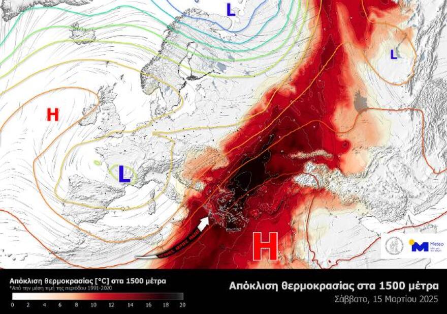
The maximum surface temperature depends on many factors, such as cloud cover and wind combined with topography, but with the current data the maximum surface temperatures seem to be very high for the season, with maximum values, especially on Saturday 15/03, in the mainland reaching 29-30 degrees Celsius locally, while in Northern Crete it will exceed 33 degrees Celsius.
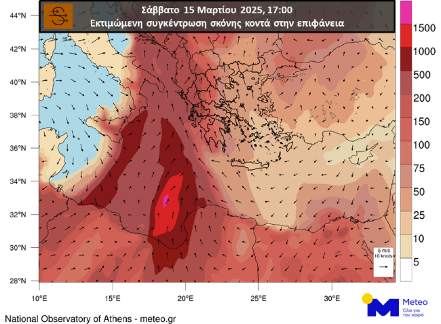
At the same time, Saharan dust will be strongly transported towards our country, mainly in the western parts, as estimated by the dust concentration forecast model of the National Observatory of Athens/meteo.gr. The estimated dust concentrations and wind field, during the afternoon hours of Saturday 15/03, are presented in Map 2 below.
Columbia: Cold transport from next Tuesday
However, weather for the rest of March holds changes, according to EMF director Thodoris Kolydas.
Specifically, in a post on X, he said: “The two waves of warm invasions ( Wednesday & weekend) and the cold transfer from next Tuesday,” citing tables explaining the change in weather.
The weather on Thursday, according to the National Weather Service
Attica
Winds: south southeastern 5 to 6 and in the east locally 7 Beaufort with gradual weakening.
Temperature: From 13 to 23 degrees Celsius.
Thessaloniki
Weather. From noon the weather will improve.
Winds: southeastern 4 to 5 Beaufort.
Temperature: From 12 to 22 degrees Celsius.
Weather forecast for Friday (14/3)
Generally clear weather with scattered clouds in the Ionian Sea, the mainland and the northern Aegean. Visibility in the morning hours will be limited in places. The transport of African dust is favoured.
Winds will blow south southeast 4 to 6 and locally in the sea 7 Beaufort. The temperature will rise slightly further and will reach 23 to 25 degrees Celsius in most areas and locally in northern Crete 26 to 27 degrees Celsius.
Forecast for Saturday (15/3)
Generally clear weather with sparse clouds that will be thicker in places until midday in the central and northern areas. Visibility in the morning hours will be locally limited. The transport of African dust is favoured.
Winds will blow south southeast 4 to 6 and in the Aegean and northern Crete 6 to 7 Beaufort. The temperature will rise further across the country and will reach 25 to 27 degrees Celsius and in northern Crete 28 to 30 degrees Celsius.
Forecast for Sunday (16/3)
In the west and the north clouds, partly cloudy. From the afternoon there will be local showers in the northwest and in the evening in Macedonia and possibly in Thrace. In the rest of the country thin clouds. African dust is favoured across the country.
Winds in the west will initially blow from southerly directions 5 to 6 Beaufort and gradually from noon from westerly directions 4 to 5 Beaufort. In the east it will blow south 5 to 6 and in the Aegean and northern Crete 7 to 8 with a slight weakening after noon. The temperature will drop slightly in the west and north, but in the east and south it will remain very high for the season.
Ask me anything
Explore related questions