
The Holy Spirit long weekend is expected to bring summer-like weather, with generally clear skies across the country and temperatures reaching up to 37°C in some areas. The heat will last at least through Monday, though meteorologists emphasize this is not a heatwave but a prolonged warm spell.
In a post, meteorologist Thodoris Kolydas mentioned that high temperatures will persist through Monday, along with unstable weather in the north.
ΖΕΣΤΗ ΚΑΙ ΑΣΤΑΘΕΙΑ – ΥΨΗΛΕΣ ΘΕΡΜΟΚΡΑΣΙΕΣ ΜΕΧΡΙ ΚΑΙ ΤΗ ΔΕΥΤΕΡΑ ΤΟΥ ΑΓΙΟΥ ΠΝΕΥΜΑΤΟΣ
— Theodoros Kolydas (@KolydasT) June 5, 2025
✅Αρκετή ζέστη σήμερα στα ηπειρωτικά με τον υδράργυρο τοπικά να φτάνει τους 36 βαθμούς Κελσίου, ενώ παράλληλα εκδηλώθηκε και αστάθεια στα βόρεια.
✅Η θερμοκρασία το Σάββατο θα ανέβει κι άλλο και… pic.twitter.com/hUM0r542TV
“Temperatures on Saturday will rise further, reaching 36–37°C. The hottest days will be Sunday and Whit Monday. From Tuesday onward, temperatures will drop and return to typical summer levels,” he noted.
However, travelers heading north might need an umbrella, as meteorologist Klearchos Marousakis warns that the warm weather pattern could bring surprises.
“A colder air mass in the mid- and upper troposphere is expected to move into our region, potentially causing dangerous thunderstorms during the afternoon and early evening in the northern parts of the country,” he stated in a social media post.
Areas with the highest recorded temperatures on Thursday:
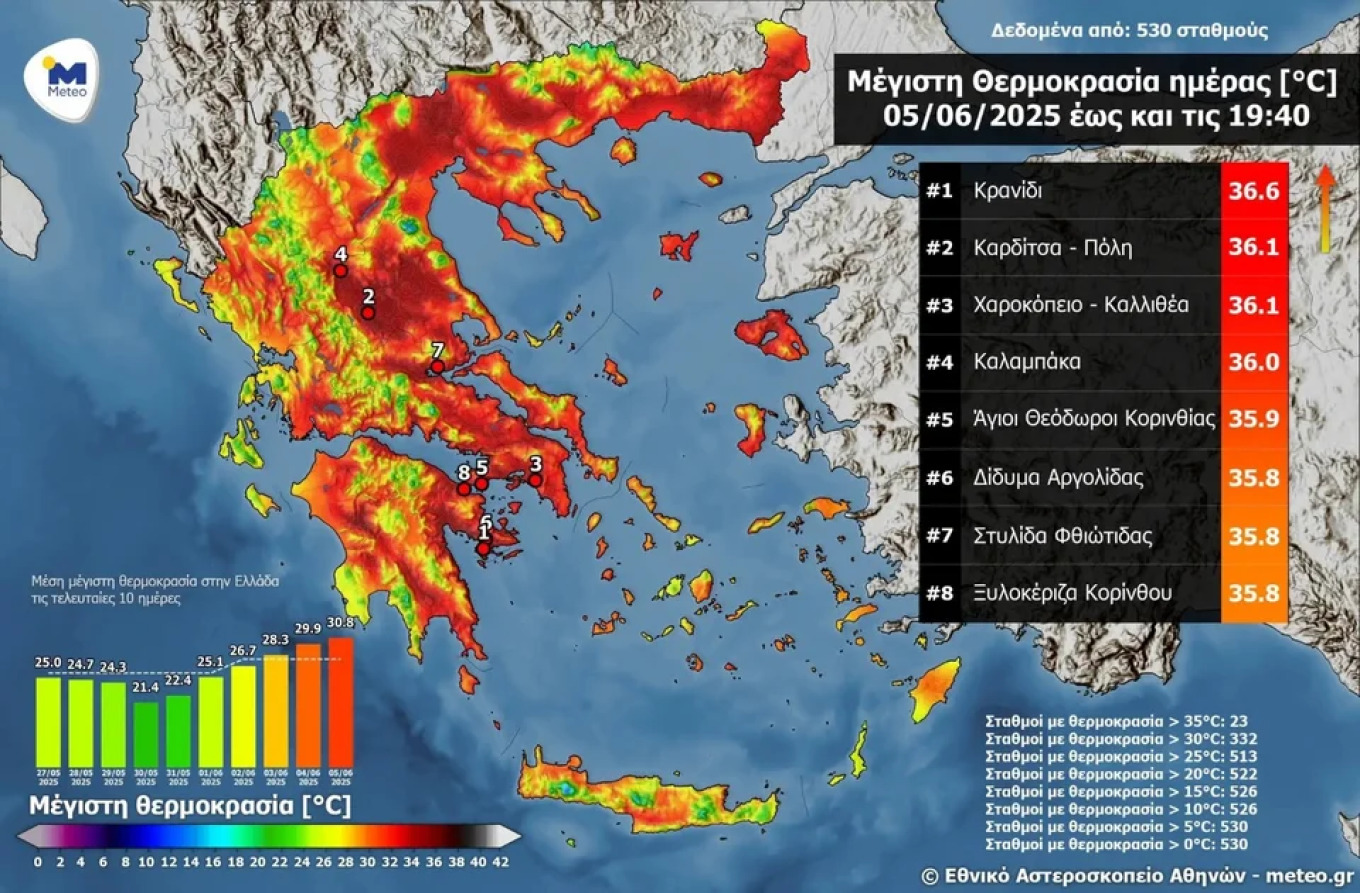
According to meteo.gr, four regions recorded temperatures above 36°C:
- Kranidi – 36.6°C
- Karditsa (City) – 36.1°C
- Harokopio, Kallithea – 36.1°C
- Kalabaka – 36.0°C
- Agioi Theodoroi, Corinthia – 35.9°C
- Didyma, Argolida – 35.8°C
- Stylida, Fthiotida – 35.8°C
- Xylokeriza, Corinth – 35.8°C
Greek seas warm in early June 2025
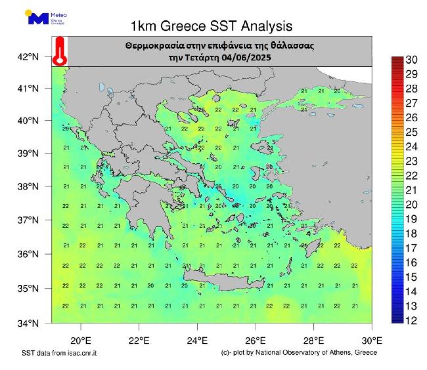
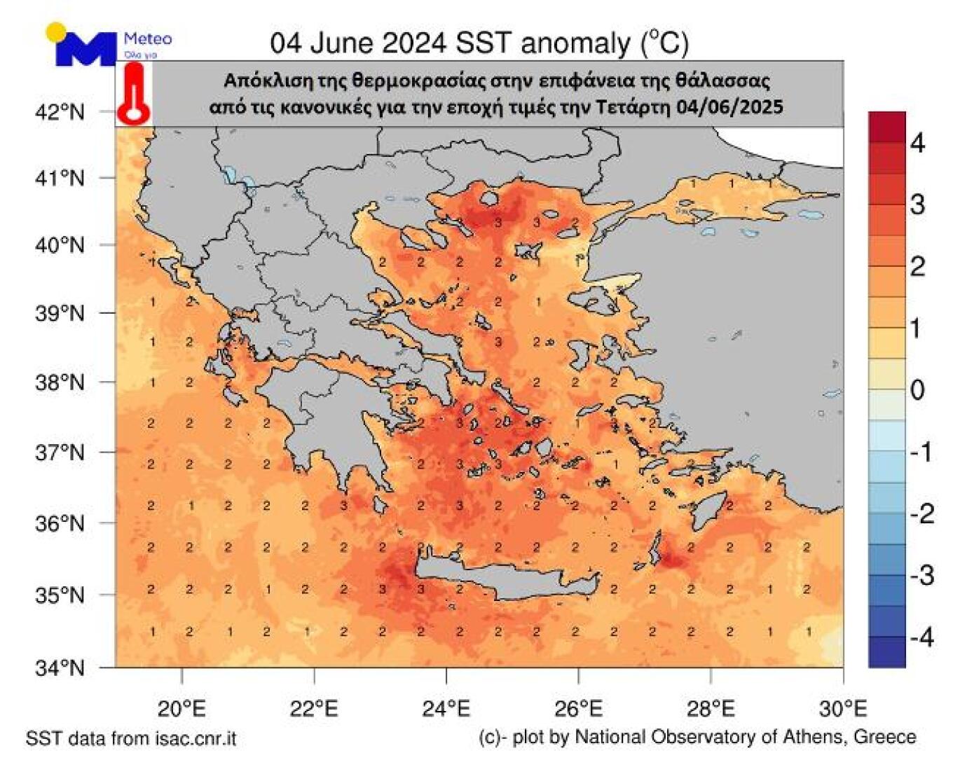
Relatively high air temperatures during the first days of June 2025, combined with a lack of strong winds, have led to an increase in sea surface temperatures. Based on satellite data analyzed by the meteo.gr unit of the National Observatory of Athens, the following patterns were observed:
- Surface water temperatures range from 20–22°C
- The Ionian Sea is approximately 2°C warmer than usual for this time of year
- The Aegean Sea is 2–3°C warmer than seasonal averages
Today’s Weather
Mostly clear skies are expected across the country, with some localized clouds. In the afternoon, cloud cover will increase over the mainland, especially in Central and Northern Greece, with showers and thunderstorms likely, particularly in mountainous areas where they may be intense.
Temperature ranges:
- Western Macedonia: 13–29°C
- Rest of Macedonia and Thrace: 16–33/35°C
- Thessaly: 16–34/36°C
- Western Greece: 17–31/32°C
- Remaining mainland: 18–34/36°C
- Ionian Islands: 16–31/32°C
- Aegean Islands and Crete: 17–31/33°C
- Eastern Aegean islands: up to 35–36°C
Winds:
- Aegean: NW winds at 4–5 Beaufort, with westerly winds in the southern parts
- Ionian: WNW winds at 3–4 Beaufort
- Corinthian Gulf: W winds at 3–5 Beaufort
Athens:
Sunny with some clouds in the afternoon. Winds N at 2–4 Beaufort. Temperatures between 22–34/35°C.
Thessaloniki:
Partly cloudy with a chance of showers or thunderstorms in the mountains during the warmer hours. Winds variable at 2–3 Beaufort. Temperatures from 23–32°C.
Ask me anything
Explore related questions


