Strong to gusty northwesterly winds and severe cold, mostly in the senses, is bringing bad weather on Sunday, with meteorologists drawing attention to areas of central Macedonia and the Sporades, while the landscape remains open for the weather conditions of New Year’s Eve.
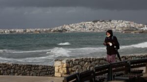
In his posts, meteorologist Thodoris Kolydas says that on Sunday, very strong northwest winds are expected in central Macedonia, including Thessaloniki, as well as in the Sporades, which will reach 8 to 9 Beaufort.
Referring to the evolution of the weather for the time change, Theodore Kolydas notes that the ECMWF and ICON forecast models converge to a milder and “cuddly” scenario. According to this version, the bulk of the cold air mass remains further east, with low pressure mainly located in the Eastern Mediterranean, and our country being in a marginal influence. The phenomena, in this case, are limited and mainly concern the eastern and southeastern Aegean, while temperatures remain winter-like, but without a strong cold invasion or extensive snow in the lowlands.
On the contrary, the GFS insists on a more “heavy” and aggressive scenario, with a deeper descent of cold air masses towards the Balkans and Greece. In this version, more widespread snowfall, lower temperatures at 850 hPa, and longer duration of cold weather are favoured, especially for the northern and eastern parts of the country. As Thodoris Kolydas points out, this is a more extreme and more isolated scenario than the others.
In conclusion, at the moment, the “scales” seem to be tipped towards the ECMWF-ICON solution, but the GFS cannot be ignored. As he points out, it will take another two to three days to provide a more secure and operational assessment of the New Year’s weather.
At the same time, Sakis Arnaoutoglou is also warning of gusty winds and particularly low temperatures, focusing mainly on Sunday and occasionally on Monday, 29 December. As he says, increased caution is required in Thessaloniki, Kilkis, Serres, and Chalkidiki.
According to Sakis Arnaoutoglou, from the early hours of Sunday morning the winds will increase significantly, with the most difficult period extending from 10:00 to late evening, around 22:00-23:00. Gusts are expected to reach 9 to 10 Beaufort and occasionally even 11, especially in exposed areas, open roads and bridges, increasing the risk of falling branches, objects and even trees.
As for the temperature, although the maximum values will be close to 12 degrees Celsius, the strong wind will significantly lower the temperature that will be perceived. As noted, at noon the perceptible temperature will not exceed 7 degrees, while in the morning and evening hours it will even approach zero.
On Monday, winds will remain strong for most of the day, with cold temperatures persisting mainly due to the intensity of the wind. For this reason, both Sunday and Monday require increased caution, with recommendations to secure items on balconies and patios, limit travel to exposed areas and wear appropriate clothing, as the cold will be particularly “bitter” compared to thermometer readings.
Icey Saturday morning in the northern mainland
Frost occurred in the morning hours of Saturday, 27/12, in the northern continental parts, but also in the mountains of the central and southern parts of the country. According to a network of automatic weather stations of the National Observatory of Athens / Meteo.gr, the minimum temperatures on Saturday 27/12 in the continental areas were at low levels as clearly shown in the temperature colour scale of the map below, with the lowest minimum temperature recorded in Lailias of Serres at -5.6 °C, while it should be noted that 53 weather stations recorded minimum temperatures below zero (frost conditions).
Today’s weather
Sunshine is forecast with a few clouds, increasing in the eastern and southern parts, with local showers in the East Aegean islands, South and West Peloponnese, South Ionian Sea, in the northern and mountainous parts of Crete, and possibly in the Cyclades. Frost will occur in the evening and early morning hours in the central and northern mainland, while visibility will be locally limited in the morning and evening hours.
The temperature will range from -3 to 12 degrees in Northern Greece (in Western Macedonia from -6 to 8 degrees), -1 to 15 degrees in Central and Southern Greece, 2 to 14 degrees in Western Greece (in Epirus from -2 to 9 degrees), 7 to 14 degrees in the Cyclades and from 4 to 16 degrees in Crete, 2 to 13 degrees in the East Aegean islands and from 7 to 14 degrees in the Dodecanese.
The winds will blow in the Aegean Sea initially from westerly directions, moderate 4-5 Beaufort, which will gradually change to northerly moderate to strong 5-6 Beaufort and locally in the North Aegean almost gusty 7 Beaufort, while in the Ionian Sea initially from variable directions, light winds which will gradually change to north-westerly moderate 4-5 Beaufort and locally in the North Ionian Sea to strong 6 Beaufort.
We expect sunshine with a few clouds and locally limited visibility in the evening and morning hours on Sunday in Attica. The temperature will range from 6 to 16 degrees Celsius, but in the north it will be 3-4 degrees lower. Winds will initially blow from the west, light to almost moderate 3-4 Beaufort, which will gradually shift to moderate north 4-5 Beaufort and occasionally to strong 6 Beaufort.
We expect sunshine on Sunday in Thessaloniki. The temperature will range from 1 to 9 degrees Celsius. The winds in Thermaikos will blow from northwestern directions, light to almost moderate 3-4 Beaufort, which will gradually increase to strong to almost gusty 6-7 Beaufort.
The weather on Monday, December 29
Generally clear weather with a few local clouds in the Aegean islands, Crete, the southern Peloponnese, and the southern Ionian Sea, with the possibility of light local rain until noon.
Winds will initially blow from the north at 4 to 6 Beaufort, in the Aegean Sea locally 7 and in the early morning hours in central Macedonia and the Sporades locally 8 Beaufort. Gradually, the winds will weaken.
In some parts of the day, the winds will become lighter and we will have a slight decrease in intensity.
The temperature will drop slightly throughout the country. It will reach 9 to 11 degrees Celsius in the north, 12 to 14 degrees in the eastern mainland, 14 to 16 degrees in the west, 15 to 17 degrees in the Cyclades and Crete, and 13 to 15 degrees Celsius on the eastern Aegean islands. Frost will occur in places early in the morning in the central and northern continents.
The weather on Tuesday, December 30
A few clouds which will quickly increase locally in the west, the south, the eastern Aegean and gradually in the rest of the regions. Scattered showers will occur initially in the Ionian Sea, the western mainland, gradually in Crete, the Cyclades and the eastern Aegean islands, and from the evening in the southern parts of Thessaly, northern Evia and the Sporades. Isolated thunderstorms will occur from midday on the eastern Aegean islands and the Ionian Sea.
Winds will blow southwest 3 to 5 and in the Aegean Sea locally 6 Beaufort. In the evening, in the north, they will turn to north 5 to 7 Beaufort.
The temperature will rise slightly, mainly in the east and north. Frost will occur in places early in the morning in the northern and central continents.
Weather on Wednesday, December 31
A few clouds locally increasing in the east and south, where there will be sporadic showers. Isolated thunderstorms may occur until noon on the East Aegean islands, Crete, and the Dodecanese. A little snow will fall in the continental mountains and in the northern and central highlands.
Winds will blow in the north from northerly directions 4 to 6 and until noon locally in the Aegean Sea 7 Beaufort. In the south, the winds will be westerly 4 to 6, gradually becoming north-westerly with the same intensity.
The temperature will drop throughout the country. Frost will occur in places in the morning hours on the mainland.
The weather on Thursday, January 1 (MONDAY)
A few clouds locally increasing in the east and south with occasional light showers until noon in the sea and coastal areas. Some snow will fall in the eastern mountains and northeastern uplands.
Winds will blow from the north at 4 to 6 Beaufort from the north.
The temperature will not change significantly. Frost will occur in places in the morning hours on the mainland.
Ask me anything
Explore related questions


