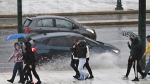
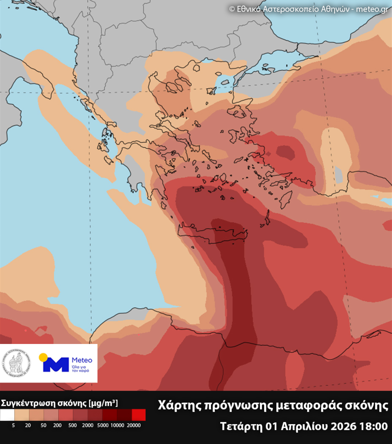
A rapid deterioration in the weather is expected on April 1, with rain and thunderstorms occurring across the country. Winds will be locally gale-force, exceeding 100 km/h, while African dust will also make its appearance, mainly in southern and central parts of the country, intensifying around midday on Wednesday and significantly affecting Crete, the Peloponnese, the Cyclades, the Southern and Eastern Aegean, and Eastern Central Greece.
The map shows concentrations of African dust near ground level on Wednesday at 21:00 (Greece time), according to the DUST-METEO forecast model of the National Observatory of Athens:
Rain, thunderstorms and African dust on Wednesday: Maps showing the areas that will be affected by intense phenomena
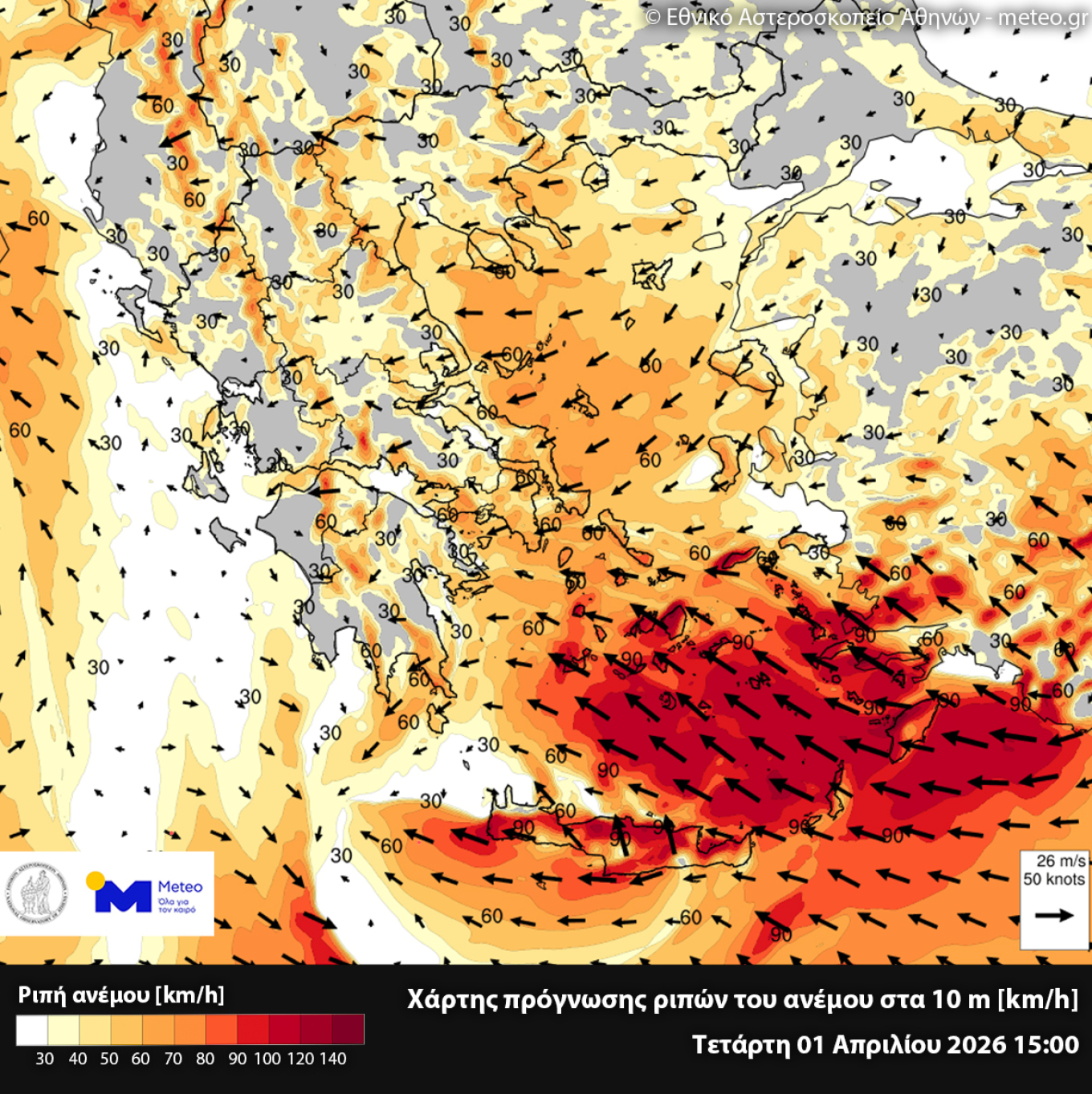
At the same time, particularly strong winds will blow in the southern Aegean tomorrow. Winds will come from easterly–southeasterly directions, locally gale-force, with the highest intensities mainly affecting Crete, the Cyclades, and the eastern and southeastern Aegean.
The map shows the field of wind gusts on Wednesday. A strong zone of intense winds is visible in the southeastern Aegean, with gusts reaching 90 km/h in these areas and locally expected to exceed even 100 km/h:
Intense phenomena on Wednesday
Heavy local rain and thunderstorms are expected both in mainland and island parts of the country. In the early morning hours, phenomena will mainly occur in the Ionian Islands and Western Greece, but will quickly spread to the rest of the country, with central and eastern mainland areas, Eastern and Southern Peloponnese, the Cyclades, Crete, and the Eastern and Southern Aegean being significantly affected. During the evening hours, the phenomena will intensify in the Northern and Eastern Aegean and in Eastern Macedonia and Thrace.
Hailstorms are expected in the early morning hours in the Ionian Islands and Western Greece, and from the afternoon in Southern Peloponnese, Crete, the Cyclades, and the Dodecanese. Gale-force winds over the seas, especially in the southeastern Aegean.
It is noted that, according to the Rainfall Episode Category Index (RPI), developed by the meteo unit of the National Observatory of Athens, this episode is classified as category 5 (Extreme).
The meteo map presents the cumulative 3-hour precipitation and pressure fields during the period 18:00–21:00 on Wednesday:
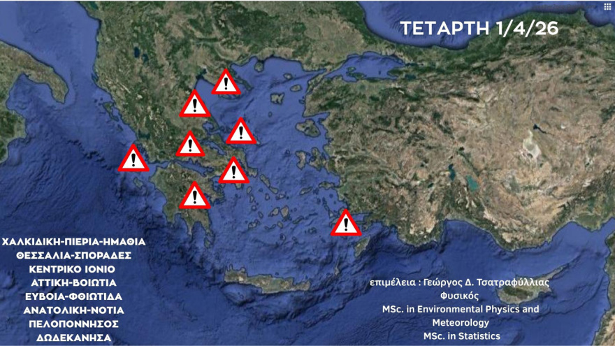
Areas under Red Code over the next 48 hours
Heightened caution is advised over the next 48 hours in parts of Greece, as meteo warns of increased risk (Red Code) due to storm Erminio.
The warnings concern intense weather phenomena, such as heavy rainfall and thunderstorms, which may cause flooding and problems to local infrastructure.
At a glance, see which areas of Greece will be under increased risk (Red Code) over the next 48 hours, according to the updated forecast by Giorgos Tsatrafyllias for heavy rain and thunderstorms.
The Risk Assessment Committee was convened by the Secretary General for Civil Protection, Nikos Papaefstathiou, today (31/3) due to the severe weather expected to sweep across the country with intense phenomena. The subject of the meeting was the Emergency Weather Warning Bulletin issued by the National Meteorological Service.
According to the committee’s scientists, heavy rain and thunderstorms are forecast:
a. In the Ionian Islands from the early morning hours
b. In eastern Peloponnese, eastern Central Greece, Evia, Thessaly, and the Sporades from the late morning hours until late at night
c. In Attica from early afternoon until late at night
d. In the Cyclades (mainly the northern parts) and the islands of the Eastern Aegean (from Chios southwards) from the afternoon until late at night
e. In the Dodecanese from the afternoon
f. Very strong southeasterly winds of intensity 8 to 9 Beaufort, and locally 10 Beaufort in the Dodecanese, will prevail in the central and southern Aegean
At the same time, the National Coordination Centre for Operations and Crisis Management (E.S.K.E.DI.K.) has already communicated with first- and second-level local authorities, as well as all involved agencies regarding the development of the weather phenomena in order to ensure operational readiness and response.
Following the Emergency Weather Warning Bulletin issued by the National Meteorological Service (EMY) and the meeting of the Risk Assessment Committee, the General Secretariat for Civil Protection has placed the following regions under mobilization (Red Code) for Wednesday 01-04-2026 and Thursday 02-04-2026:
-Attica
-Central Greece
-Thessaly, including the Sporades
-Peloponnese
-South Aegean
-as well as the regional units of Imathia and Pieria in the Region of Central Macedonia
Emergency bulletin updated
At the same time earlier today at noon, the National Meteorological Service updated the Emergency Weather Warning Bulletin it had issued on Monday (30/3).
In detail, the full emergency bulletin:
“The Emergency Weather Warning Bulletin no. 4 issued on Monday 30-03-26 at 12:15 local time is updated according to the latest forecast data.
A weather system in the central Mediterranean, named ERMINIO, is expected to affect most areas of the country on Wednesday 01-04-26 and Thursday 02-04-26, bringing prolonged and intense rainfall and thunderstorms, and possibly local hail.
On Wednesday, in the eastern parts of the country, easterly to southeasterly winds of intensity 7 to 9 Beaufort and locally 10 Beaufort in the Dodecanese will prevail. Heavy snowfall is expected on Wednesday in the mountainous areas of Epirus and Macedonia.
Heavy rain and thunderstorms are forecast more specifically:
On Wednesday (01-04-26)
a. In the Ionian Islands from the early morning hours and in southwestern Peloponnese from midday (orange warning).
b. In eastern Peloponnese from the late morning hours until late at night (red warning).
c. In eastern Central Greece, Evia, Thessaly, and the Sporades from midday until late at night (red warning).
d. In Pieria from midday until the evening (orange warning).
e. In Attica from midday until late at night (red warning).
f. In the northern Cyclades from the afternoon until late at night (orange warning).
g. In the islands of the Eastern Aegean from late afternoon until late at night (orange warning).
h. In the Dodecanese from the afternoon (red warning).
i. In eastern Crete during the afternoon–evening hours (orange warning).
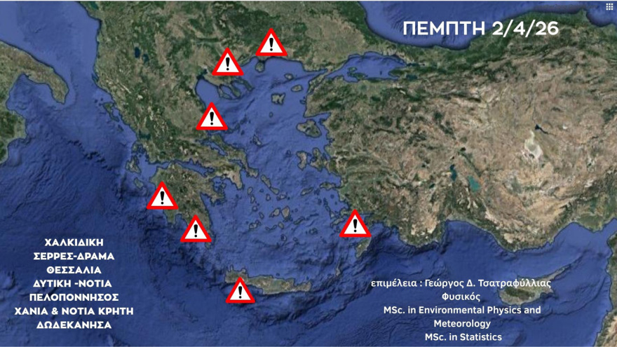
On Thursday (02-04-26)
a. In western and southern Peloponnese from the morning hours until late at night (red warning).
b. In eastern Thessaly (regional units of Larissa and Magnesia, including the Sporades) from the early hours until midday (orange warning).
c. In the regional units of Central Macedonia: Pieria, Imathia, Halkidiki, and Serres from the morning hours until late afternoon (orange warning).
d. In Crete (mainly western and southern parts) from midday until late at night (red warning).
e. In the islands of the Eastern Aegean from late afternoon (orange warning).
f. In the Dodecanese in the early hours of the day (red warning) and again from late afternoon (orange warning).
Ask me anything
Explore related questions