As winds turn southerly, the path opens for the transport of dust and heat from Africa, according to meteorologist Giorgos Tsatrafyllias in his forecast for protothema.gr. He also notes that muddy rainfalls will not be absent over the next two days.
More specifically:
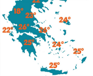
For today, Thursday (7/5), cloudiness is expected, which after midday will bring some rain to central and northern Greece. The transport of Saharan dust is also favored, with mild concentrations in western and southern regions.
Maximum temperatures will reach 25–26°C across mainland Greece, Crete, and the Dodecanese. During the evening, temperatures will not drop below 16–17°C in lowland and coastal areas.
Winds in the Ionian Sea will blow from the southeast at up to 6 Beaufort. In the Aegean, southerly and southwesterly winds will reach up to 5 Beaufort.
– In Attica, slight cloudiness is expected. Winds will blow from southern directions at up to 4 Beaufort. Temperatures will range from 14°C to 26°C.
– In Thessaloniki, light rain is expected around midday. Winds in the Thermaic Gulf will be weak, while temperatures will range from 14°C to 21°C.
The weather outlook for the coming days
On Friday, and to a lesser extent on Saturday, southerly winds will strengthen, favoring the transport of larger amounts of African dust into central and southern Greece. Muddy rainfalls are expected in central and northern areas.
Additionally, scattered thunderstorms are forecast in western and northern regions.
From Sunday onward, with the dust still present, temperatures will rise further. At the beginning of next week, temperatures are expected to exceed 31–32°C.
Ask me anything
Explore related questions


