Showers with frequent lightning in mainland Greece, sunny conditions on the islands, and a drop in temperatures toward the end of the week. According to meteorologist Giorgos Tsatrafyllias of protothema.gr, this is the weather pattern that will affect the coming days, with instability persisting mainly during the warmest hours of the day.
More specifically, today, Wednesday 10 June 2026, the day will start with plenty of sunshine in most areas. However, during the midday and afternoon hours, local showers and thunderstorms will develop in mainland regions, mainly in mountainous and semi-mountainous areas.
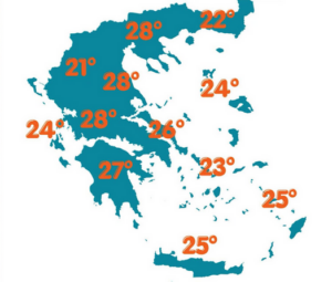
Maximum temperatures will reach 32–33°C in mainland Greece, while in Crete, the Dodecanese, and other island regions they will range around 30–31°C. Winds will blow from northwesterly directions. In the Aegean Sea they may locally reach 6 Beaufort, while in the Ionian Sea winds will generally be light.
In Attica, the weather will be generally clear. Winds will be northerly at 3–5 Beaufort, and temperatures will range from 18 to 32°C.
In Thessaloniki, local and brief rain showers are expected from midday onward. Winds in the Thermaic Gulf will be light, while temperatures will reach 32°C.
Weather pattern for the coming days
On Thursday, instability will persist in mainland areas, while on Friday it is expected to intensify. At the same time, temperatures will begin to gradually drop.
Over the weekend, temperatures will decrease further, while rainfall will become more limited. At the same time, the “meltemi” winds will strengthen to 6–7 Beaufort.
Ask me anything
Explore related questions


