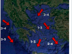





Severe weather continues to affect Greece, with heavy rain and thunderstorms forecast for today, Monday 26 October, and tomorrow, Tuesday 27 October, mainly in eastern parts of the country. Localised hailstorms are also possible. The Hellenic National Meteorological Service (HNMS) has updated its emergency severe weather bulletin, highlighting changes from the original forecast. Particular caution is advised in Attica, Thessaly, Evia, the Sporades and the eastern Aegean islands, while forecast data indicate that unsettled conditions will persist in several areas on Wednesday 28 October, potentially affecting the national day parades.
The deterioration in the weather was already being felt on Sunday evening, when severe thunderstorms caused problems in parts of Attica, with roads turning into rivers in Mandra and Glyfada.
According to the National Observatory of Athens’ meteo.gr service, successive atmospheric disturbances will maintain unsettled conditions until at least Wednesday. The main features will be heavy rainfall, a gradual drop in temperatures and strengthening winds, which will locally reach Force 8 over the open sea.
Updated HNMS Severe Weather Bulletin: Where Storms Will Hit Today
According to the HNMS, locally heavy rain and thunderstorms are forecast today, Monday 26 October, in the following areas:
- Eastern Central Greece: Mainly in the regional units of Phthiotis and Boeotia until the morning.
- Attica: Until midday, with a further spell of severe weather expected in the evening.
- Thessaly: In the regional units of Magnesia and Larissa until the evening.
- The Sporades and Evia: Severe weather throughout the day.
- The Dodecanese: From late morning until late evening.
- The eastern Aegean islands: From midday onwards.
Localised hailstorms are also possible in the areas expected to be most severely affected.
Beyond the areas covered by the HNMS warning, meteo.gr forecasts cloudy skies, rain and thunderstorms in the Ionian Islands, the Peloponnese, Central Greece, Thessaly, the Sporades, Evia, the eastern Aegean islands, the Dodecanese and Crete. Lighter rainfall is expected elsewhere in the country.
Temperatures will fall slightly, with maximum values in most areas not exceeding 19–22°C.
In Western Macedonia, temperatures will range from 8°C to 19°C; in the rest of Macedonia and Thrace, from 11°C to 21°C; in Epirus, from 11°C to 22°C; in Thessaly, from 12°C to 20°C; in Central Greece, from 12°C to 21°C; and in the Peloponnese, from 13°C to 22°C.
In the Ionian Islands, temperatures will reach 22°C; in the northern and north-eastern Aegean islands, 21°C; in the remaining Aegean islands, 22°C; in the Dodecanese, 25°C; and in Crete, 22°C.
Winds in western Greece will blow from the north-west, while in the east they will come mainly from easterly to north-easterly directions, reaching Force 4–6 and strengthening further over the open sea, where they will locally reach Force 7–8.
Attica: More Severe Storms After Flooded Roads in Mandra and Glyfada
Particular caution is needed in Attica today, where the HNMS forecasts two periods of severe weather: one lasting until midday and a second during the evening.
According to meteo.gr, cloudy skies, rain and thunderstorms are expected, particularly in the early morning. Winds will blow from the east-north-east at Force 3–4, turning northerly in the evening and reaching Force 5. Temperatures will range from 15°C to 19°C.
The renewed deterioration comes after Sunday’s heavy rainfall, which caused problems in several parts of the wider Athens metropolitan area.
The most severe conditions were recorded in Piraeus and Mandra, where large volumes of water turned roads into raging torrents. Similar scenes were reported in Glyfada, while heavy rain also hit Voula, Vari, Anavyssos, Elliniko, Agios Kosmas and Lavrio.
On Karamanli Avenue in Voula, traffic police temporarily closed the road to traffic heading towards Piraeus, between Vasileos Pavlou Street and Crete Square, due to water accumulation. Traffic was subsequently restored.
Rainfall was also recorded in Nikaia, Perama, Ano Korydallos and Faliro, as well as in central Athens, Gazi, Peristeri, Chaidari, Psychiko and Kaisariani.
The severe weather also affected the northern suburbs, with rain in Drosia and Dionysos, as well as in Malakasa.
Today’s Weather in Thessaloniki
Cloudy skies and localised rain are expected in Thessaloniki, although the area is not included in the zones covered by the HNMS warning for severe weather.
Winds will blow from the north-west at Force 3–6, while temperatures will range from 12°C to 19°C.
Tuesday 27 October: Where Heavy Rain and Thunderstorms Will Continue
Severe weather will continue tomorrow, Tuesday 27 October, with the most intense conditions persisting mainly in eastern Greece and the islands.
According to the updated HNMS severe weather bulletin, heavy rain and thunderstorms are forecast in the following areas:
- The Sporades and Evia: Until midday, with a further spell of severe weather in the evening.
- The eastern Aegean islands: Until late afternoon.
- The Dodecanese: From midday onwards.
- Attica: Until the morning.
- Thessaly: In Magnesia and Larissa from the evening onwards.
According to meteo.gr forecasts, rainfall will generally persist across eastern and southern parts of the country, while temperatures will fall further.
Maximum temperatures are expected to reach 18–21°C in most areas, while in western Greece, Crete and the Dodecanese they may reach 22–23°C.
Winds over the open sea will remain strong, reaching Force 7 and locally Force 8, creating adverse conditions for sea travel.
What Will the Weather Be Like on 28 October? Where Rain Could Affect the Parades
Attention is now also turning to Wednesday 28 October, Greece’s national day, as the severe weather could affect the staging of parades in some areas.
Available forecast data indicate that the most severe conditions will gradually ease, although a complete improvement is not expected across the entire country.
According to meteo.gr, unsettled conditions will persist in eastern and southern Greece until Wednesday, while temperatures will fall further.
In Attica, there is a chance of rain during the morning, when school parades take place. Conditions may gradually improve later in the day, although the precise timing will depend on the movement of the weather system.
In Thessaloniki, where the major military parade will take place, forecasts are more favourable so far. Generally better weather is expected, with no significant weather phenomena, although temperatures will be lower and winds will remain noticeable.
Western and northern Greece are forecast to experience longer periods of improved weather, while the likelihood of rainfall is greater in parts of eastern Central Greece, Evia, the Sporades, the eastern Peloponnese, the Cyclades, Crete and the Dodecanese.
Strong northerly winds are also expected to be a feature of the weather, particularly in the Aegean, where gusts may locally reach Force 7–8.
However, the HNMS severe weather bulletin currently covers Monday and Tuesday, while the outlook for the 28 October parades is based on the available general and local forecasts, which may be updated.
Civil Protection and Fire Service on Heightened Alert
The relevant authorities have been placed on heightened alert, as the General Secretariat for Civil Protection has informed regional authorities, municipalities and the state agencies involved about the need to address potential problems caused by the severe weather.
Meanwhile, the Fire Service has activated its operational plan for dealing with flooding and its consequences, with services in the areas at the centre of the severe weather remaining on standby.
Civil Protection advises the public to secure objects that could be blown away by strong winds, check downpipes and gutters, and avoid crossing torrents, streams and flooded roads, even several hours after rainfall has stopped.
Particular caution is required during thunderstorms accompanied by intense lightning. People are advised to avoid outdoor work, sea-based activities, tall trees, metal structures and areas where there is a risk of falling objects.
Anyone in a car during a severe thunderstorm should stop in a safe place, away from trees and flooded roads, and remain inside the vehicle until conditions ease.
In the event of hail, people are advised to seek shelter immediately in a building or car. Anyone outdoors during intense lightning activity should find a safe shelter and keep away from seas, lakes and rivers.
The public is urged to follow the latest HNMS forecasts, Civil Protection announcements and traffic police updates on road conditions.
Ask me anything
Explore related questions