Gusty north winds expected to reach up to 9 gusts will be the main feature of the weather for the next two days, with instability expected to be limited, according to Thodoris Kolydas.
“Gusty N-NE winds will prevail over the next two days in the Aegean, mainly affecting the NE Aegean Central , Kafireas , SW Aegean and the Kythera Sea. From early Monday morning the wind gusts in these areas will reach up to 9 Beaufort. Those who intend to travel are advised to contact the local Port Authorities, because there may be a ban,” says the Star meteorologist.
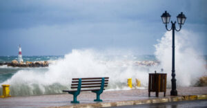
Significant strengthening of northerly winds in the Aegean Sea and the eastern continents
According to the latest forecasts of the National Observatory of Athens / meteo.gr, the change in atmospheric circulation in the coming hours over Southeastern Europe, with the rapid development of high pressure over the Balkans, will result in a gradual and significant strengthening of north-northeasterly winds in the Aegean Sea and the eastern continents, mainly on Monday 28/04.
Thus, north-northeast winds are expected to prevail today in the Aegean Sea with intensities up to 6-7 and locally 8 Beaufort, while in the Ionian Sea generally east-northeast winds with intensities up to 4-5 and locally 6 Beaufort are expected. Wind gusts in parts of the Aegean and the mainland are expected to exceed 70-80 km/h and locally 90-100 km/h, for the morning and afternoon hours of Monday 28/04. At the same time, with the prevalence of northerly winds on Monday 28/04, a slight drop in temperature in the eastern part of the country is expected, up to 3-4 degrees compared to the values of Sunday 28/04.
Freezing of departure from the port of Rafina
GOLDEN STAR FERRIES informs that due to extremely unfavourable conditions in the sailing areas of the ships SUPERFERRY & SUPEREXPRESS today 28/04 their sailings from Rafina at 07:20 (SUPER EXPRESS) to Tinos, Mykonos, Paros, Ios, Thira and back and 07:50 (SUPER EXPRESS) to Andros, Tinos, Mykonos and back will not take place.
Also, due to the forecast of unfavourable conditions today the following services will not be operated:
E/G/G Theologos P 28/4 from Mykonos 07:35 to Tinos-Andros-Rafina (cancelled).
N/A FAST FERIES ANDROS from Rafina 07:30 for Andros-Tinos-Mykonos and from Mykonos 13:15 for Tinos-Andros-Rafina (cancelled).
The route of Monday 28/4/2025 at 14:45 from Piraeus to Serifos, Sifnos, Kimolos, Folegandros, Sikinos, Ios, Thira and the return on Tuesday 29/04/2025 from Thira at 08:30 to Ios, Sikinos, Folegandros, Kimolos, Sifnos, Serifos, Serifos, Piraeus will remain unfulfilled.
It is reminded that regardless of the weather conditions, the ships will remain tied up in the ports of the country on May Day as the administration of the Panhellenic Maritime Federation (PNO) decided to participate in the nationwide – all-employer 24-hour strike called by the GSEE in the framework of the festivities for May Day.
The weather today
Local clouds are expected, sometimes more cloudy, mainly in the northwestern mainland, as well as in parts of the Aegean and the eastern mainland. Local showers are expected in parts of western and central Macedonia mainly in the morning hours with gradual improvement, while local showers are expected in Crete with emphasis on mountainous parts. There is a possibility of local rain in the East Aegean islands and the Dodecanese.
The temperature will range from 4 to 18 degrees Celsius in Western Macedonia, from 4 to 22 degrees Celsius in the rest of Macedonia and Thrace, from 5 to 20 degrees Celsius in Thessaly, from 3 to 24 degrees Celsius in Epirus, from 4 to 27 degrees Celsius in the rest of the mainland, from 11 to 23-25 degrees Celsius in the Ionian Islands and from 11 to 21-22 degrees Celsius in the Aegean Islands and Crete.
Winds in the Aegean will be generally north-northeast with intensities up to 6-7 and locally 8 Beaufort. In the Ionian Sea the winds will blow generally east-northeast with intensities up to 4-5 and locally 6 Beaufort.
In Attica, local clouds are expected, sometimes more intense. The winds will blow from northerly directions with intensities up to 4-5 Beaufort and in the east up to 6-7 Beaufort. The temperature will range from 13 to 17-18 degrees Celsius.
In Thessaloniki clouds are expected mainly in the morning hours with gradual improvement. Winds will blow from various directions with intensities up to 2-3
The weather on Tuesday 29-04-2025
Generally clear weather in most of the country. Partly cloudy skies are expected in eastern Central Greece, Evia and the Peloponnese, while in Crete, the Cyclades and the Dodecanese there will be local rainfall.
The winds will blow in the west east northeast 4 to 5 and locally in the Ionian Sea up to 6 Beaufort and in the east north northeast 5 to 7 and in the Aegean Sea locally 8 Beaufort.
The temperature will drop slightly mainly in the south and will reach 18 to 20 degrees Celsius in the north, 21 to 22 degrees Celsius in the west and the Dodecanese and 17 to 18 degrees Celsius in the rest of the mainland and the eastern islands.
The weather on Wednesday 30-04-2025
In the central and southern Aegean Sea and in the southern Peloponnese, clouds with local rain and possibly in the Dodecanese isolated thunderstorms are forecasted. In the rest of the country, generally clear weather with thin clouds.
Winds will blow from the north in the west 3 to 5 Beaufort and in the east 5 to 7 Beaufort and in some places in the Aegean Sea 8 Beaufort.
The temperature will rise slightly.
The weather on Thursday 01-05-2025
In the Cyclades, Crete and the Dodecanese the weather will be unsettled with showers and occasional thunderstorms. In the rest of the country the weather will be almost clear.
Winds will blow from the north, in the west 4 to 6 Beaufort, in the east 5 to 7 and locally in the Aegean Sea 8 Beaufort.
The weather will be pleasant in the north-eastern part of the country, with winds in the north-eastern part of the country and in the south-eastern part of the country.
The temperature will rise slightly further, mainly in the west.
The weather on Friday 02-05-2025
In Crete, the eastern Cyclades and the Dodecanese the weather will be unsettled with showers and occasional thunderstorms and weakening from the evening. In the rest of the country there will be a few clouds, which will increase in the midday and afternoon hours and there will be local rain in the mainland and isolated thunderstorms in the mountains.
Winds will blow from the north, in the west 3 to 5 Beaufort and locally in the Ionian Sea 6 Beaufort and in the east 5 to 7 Beaufort and in the Aegean Sea in some places occasionally in the morning hours 8 Beaufort.
The temperature will not change significantly.
Ask me anything
Explore related questions


