Related Stories

Why is Gaza, one of the most densely populated places in the world, blurry on Google Maps?
It’s an issue that has been highlighted by researchers using open-source, publicly available information – including mapping data – to locate attacks and document the destruction.
In fact, much of both Israel and the Palestinian territories appear on Google Earth as low-resolution satellite imagery, even though higher-quality images are available from satellite companies.
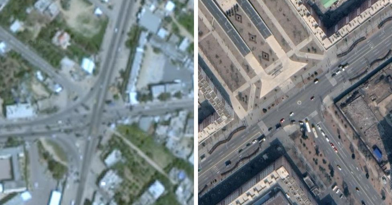
It’s barely possible to see the cars in Gaza City.
Compare that with Pyongyang, the secretive capital of North Korea, where the cars are sharply defined and it’s possible to make out individual people.
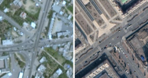
(Google Earth image of Gaza on the left, and on the right the most recently available image of Pyongyang, North Korea)
Twitter suspends Spanish politician’s account for saying “a man cannot get pregnant”
Greek Minority in Albania: 107 years since the signing of the Protocol of Corfu (photos)
Why is satellite imagery important?
It has become a vital element in the reporting of conflict, but there are also concerns the availability of detailed images can compromise security.
In the latest Middle East confrontation, investigators are looking to corroborate the locations of missile fire and targeted buildings in Gaza and Israel, using satellites.
“The fact that we don’t get high-resolution satellite images from Israel and Palestinian territories sets us back,” says Samir, an open-source investigator.
However, on Google Earth, the most widely used image platform, the most recent imagery for Gaza is of low resolution and therefore blurry.
Read more: BBC