
A sharp deterioration in weather conditions is expected in the coming hours, prompting the HNMS to update the emergency bulletin initially issued yesterday afternoon.
The storm system, named Bora, stems from a low-pressure system over the Ionian Sea, slowly moving eastward. It will bring heavy rain and thunderstorms across the country through Monday (02/12/2024). Concurrently, very strong and occasionally gale-force winds will prevail, while dense snowfall is expected in the mountainous regions of Macedonia and Epirus.
More specifically, the forecast includes:
1. Heavy Rain and Thunderstorms
a. In central and eastern Macedonia and Thrace, from early Saturday morning (30/11/24) until Monday morning (02/12/24).
Notably, in central Macedonia (particularly in the prefectures of Chalkidiki, Thessaloniki, Pieria, and Imathia), the phenomena will be especially intense from Saturday afternoon (30/11/24) to Sunday evening (01/12/24).
b. In the Ionian Islands, Epirus, and western Central Greece, intermittently until early Saturday evening (30/11/24).
c. In western and southern Peloponnese, from early Saturday morning (30/11/24) until late evening.
d. In Thessaly, the Sporades, the islands of the Eastern Aegean, and the Dodecanese, from Saturday afternoon (30/11/24) to Monday morning (02/12/24).
e. In eastern Central Greece (including Attica) and Evia, from Saturday afternoon (30/11/24) to Sunday morning (01/12/24).
f. In western Crete and the Cyclades, from Saturday noon (30/11/24) to Sunday morning.
2. Gale-Force Winds
In central and eastern Macedonia and Thrace, expect gale-force east-northeast winds (8-9 Beaufort) from Saturday afternoon (30/11/24) until late Sunday afternoon (01/12/24)
3. Intense Snowfall
Heavy snow is forecast from Saturday afternoon (30/11/24) through Sunday evening (01/12/24) in the mountainous areas of Macedonia and Epirus.

Prolonged Severe Weather Due to Cold Air Mass
According to forecasts by Meteo.gr/NOA, one of the defining features of Storm Bora over the weekend (30/11-01/12) will be dense snowfall, primarily in the mountainous regions of central and northern Greece, as well as in lower-altitude areas of western Macedonia.
Heavy snowfall and significant accumulations are expected in the city of Florina.
A forecast map illustrates the geographical distribution and estimated total snow accumulation across the country by Sunday noon (01/12).
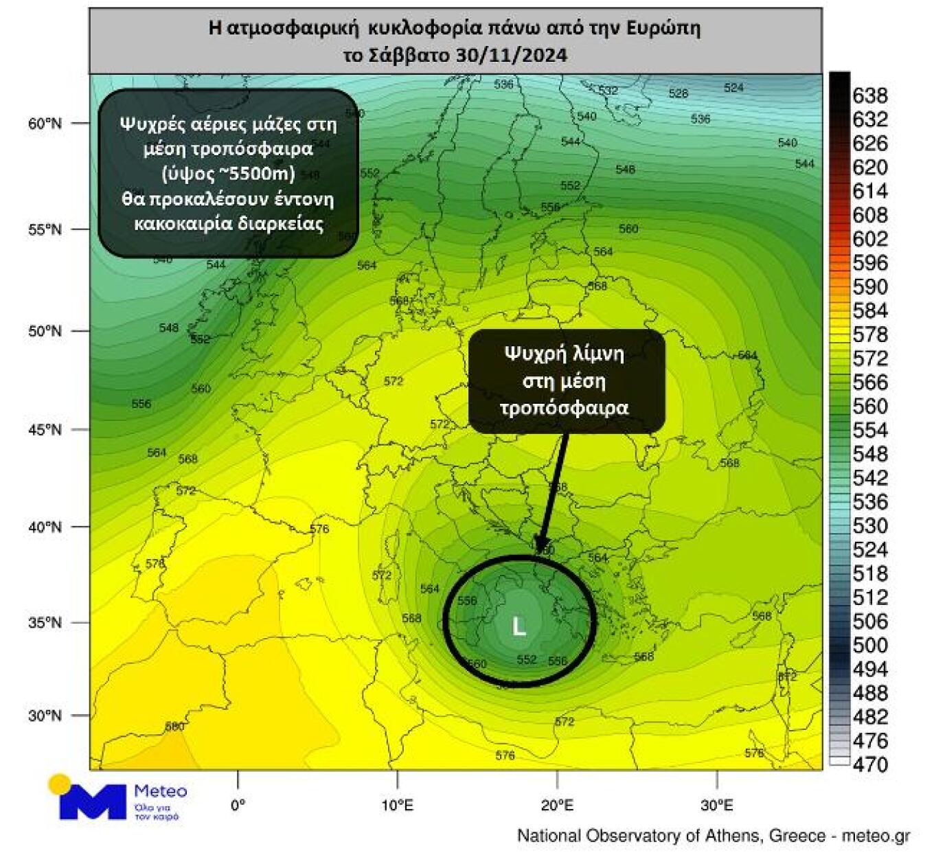
The sudden change in weather is attributed to a mid-tropospheric atmospheric disturbance, which is expected to detach from the general atmospheric circulation (cold air mass – see Chart 1). This system will slowly move southward, initially over the southern Ionian Sea and later towards the southern Aegean. The slow progression of the cold air mass, combined with the associated low-pressure system, will result in persistent and severe weather phenomena across many parts of the country.
The regions most affected include the western and southwestern mainland, parts of eastern mainland Greece bordering the Aegean, Evia, the Sporades, Chalkidiki, and parts of central Macedonia. Significant effects are also expected in the rest of the country, excluding Thrace.
On Monday (02/12), intense weather phenomena will concentrate in the eastern and southern parts of the country, particularly the Cyclades, Crete, and the Dodecanese. Weather improvement is expected from Tuesday (03/12).
Based on the Rainfall Episode Classification (RPI) by the Meteo unit of the National Observatory of Athens, the anticipated rainfall event ranks as Category 5 (Extreme).
The following forecast map shows the estimated cumulative rainfall through Sunday morning (01/12/2024).

Today’s Weather
Rain is expected nationwide, initially in the west and progressively becoming intense in many areas. Thunderstorms, mainly in the western, eastern, and southern parts of the country and the Aegean, may be accompanied by localized hail. Dense snowfall is forecast for mountainous regions and lower elevations in western Macedonia, with intense snowfall in the city of Florina. From late afternoon, particularly heavy rain is expected in eastern Thessaly, the prefectures of Imathia, Pieria, Chalkidiki, Thessaloniki, and possibly the Sporades.
Temperatures
- Western Macedonia: -2°C to 5°C
- Rest of Northern Greece: 4°C to 14°C
- Thessaly: 6°C to 15°C
- Epirus: 10°C to 16°C
- Other Mainland Areas: 8°C to 18-19°C
- Ionian Islands: 11°C to 16°C
- Northern and Northeastern Aegean Islands: 11°C to 16°C
- Other Aegean Islands and Crete: 12°C to 18-20°C
Winds
In the Aegean, winds will be southerly to southeast at 4-5 Beaufort, strengthening to 6-7 Beaufort, while in the northern Aegean, they will shift to east-northeast and strengthen to 7-8 Beaufort, possibly reaching 9 Beaufort by evening. In the northern Ionian, northwest winds will blow at 4-5 Beaufort, while in the southern Ionian, southwest winds will prevail at similar strengths, strengthening locally to 8 Beaufort in the southernmost parts by evening. Note that locally gale-force winds are expected inland, particularly in central Macedonia (notably in Chalkidiki, Thessaloniki, Pieria, and Imathia prefectures).
Ask me anything
Explore related questions