
The weather will remain mild through at least the end of the month with above-normal temperatures. Today, showers are expected in the Dodecanese and a slight drop in temperature, while more rain is expected in the country from Thursday, according to EMY.
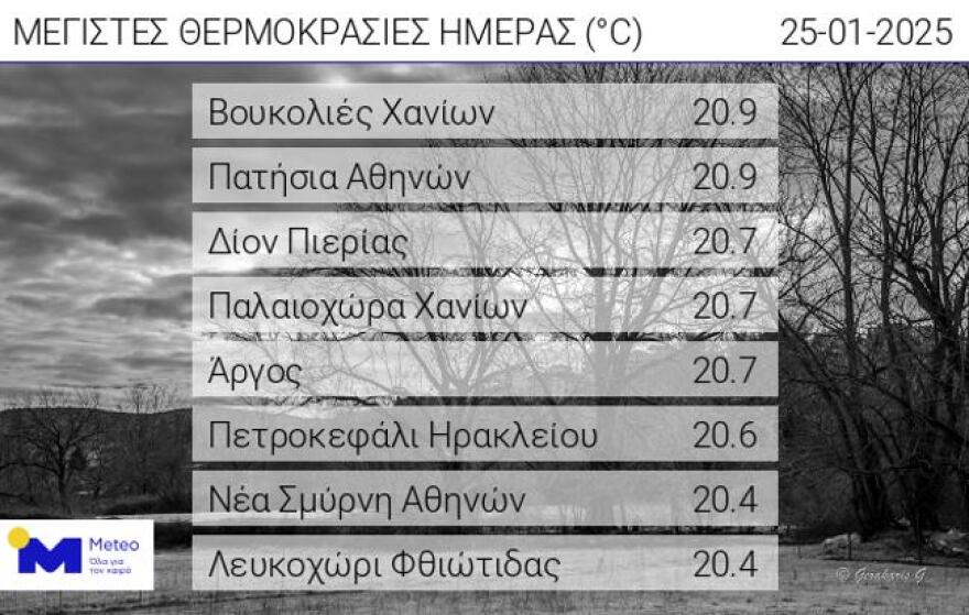
Temperatures exceeded 20°C yesterday on the mainland and in Crete
Temperatures exceeded 20 °C in the mainland and Crete on Saturday 25/01/2025, with the highest maximum temperature recorded in Voukolies of Chania and Patisia of Athens at 20.9 °C. According to the network of automatic weather stations of the National Observatory of Athens / meteo.gr, the eight highest maximum temperatures during the midday hours of Saturday 25/01 are shown in the following Table.
Today’s weather
Sunshine is forecast with a few clouds gradually increasing, with local rain in the morning hours in the Dodecanese and afternoon in the western Peloponnese and western Central Greece. In the evening and morning hours, mainly in the mainland, visibility will be limited in places and fog will occur, while frost will occur in the northern mainland.
The temperature will range from -1 to 12 degrees in Northern Greece (in Western Macedonia from -2 to 9 degrees), 4 to 16 degrees in Central and Southern Greece, 5 to 17 degrees in Western Greece (in Epirus from 2 to 13 degrees), 9 to 16 degrees in the Cyclades and Crete, 7 to 16 degrees in the East Aegean islands and the Dodecanese.
Winds will blow in the Aegean from northerly directions, light to almost moderate 3-4 Beaufort, and in the southern Aegean locally moderate 5 Beaufort, while in the Ionian Sea from southeastern directions, light to almost moderate 3-4 Beaufort.
Sunshine with a few clouds at times thicker and limited visibility in the morning and evening hours are expected on Sunday in Attica. The temperature will range from 8 to 16 degrees Celsius, but in the north, it will be 2 to 3 degrees lower. Winds will blow from the north, light,t and in the east in the morning hours almost moderate at 4 Beaufort.
We expect intermittent clouds on Sunday in Thessaloniki. The temperature will range from 6 to 12 degrees Celsius. The winds in Thermaikos will blow from southeastern directions, light.
Weather Forecast for the Week: January 27–30, 2025
Monday, January 27, 2025
Thin clouds will be present in various areas, occasionally becoming denser, with the possibility of light, localized rain in the west. Morning and evening visibility will be limited in some regions, and fog is likely to form over the mainland.
- Winds: Variable, blowing at 3–4 Beaufort.
- Temperature: A slight increase is expected.
Tuesday, January 28, 2025
Partly cloudy skies will prevail across the country, with localized increases and chances of light rain in the west, the Cyclades, Crete, the islands of the eastern Aegean, and the Dodecanese. Morning and evening visibility will remain limited in places, with fog likely to form on the mainland.
- Winds: From southern directions, 3–4 Beaufort; in seas locally reaching 5 and occasionally up to 6 Beaufort in the north.
- Temperature: A slight further rise, especially in southern regions.
Wednesday, January 29, 2025
The northwest will experience increasing clouds, bringing showers and occasional thunderstorms. In the rest of the country, partly cloudy skies will be locally denser at times, with a chance of light rain mainly over the eastern Aegean islands and the Dodecanese. Morning and evening visibility will remain limited in places.
- Winds: Southerly winds in the west at 3–5 Beaufort, with local increases up to 6 Beaufort in seas.
- Temperature: No significant change.
Thursday, January 30, 2025
Cloud cover will increase across the country, accompanied by local rain, initially affecting the west and the eastern Aegean islands, and gradually spreading elsewhere. Sporadic thunderstorms are expected over coastal and sea regions. Rainfall will ease in the west by evening, with light snow anticipated in the mountainous areas of northwestern Greece.
- Winds: South winds at 4–6 Beaufort, reaching 7 Beaufort locally.
- Temperature: No significant change.
Stay updated for changes and plan accordingly for areas with expected rain or reduced visibility.
Ask me anything
Explore related questions


