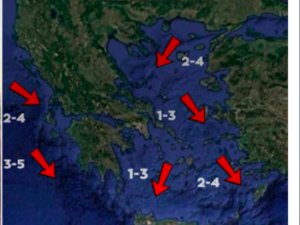
The General Secretariat for Civil Protection is issuing recommendations for citizens to exercise particular caution and take self-protection measures against risks posed by the expected severe weather conditions due to the arrival of the Coral storm.
Coral Storm: Gradual Deterioration from Wednesday – Affected Areas
According to the Emergency Weather Deterioration Bulletin (EWDB) issued today, Tuesday, February 18, 2025, by the National Meteorological Service (EMY), the weather is expected to gradually worsen from Wednesday. A severe cold wave, named Coral, will prevail over Greece and the broader region of Southeastern Europe until next Monday.
⚠️ Έκτακτο Δελτίο Επιδείνωσης Καιρού #ΕΔΕΚ #EMY
— Πυροσβεστικό Σώμα (@pyrosvestiki) February 18, 2025
🌨️ Σταδιακή επιδείνωση από αύριο Τετάρτη με σημαντική πτώση θερμοκρασίας, θυελλώδεις βόρειους ανέμους & χιονοπτώσεις
🚨 Επιχειρησιακή ετοιμότητα Πυροσβεστικού Σώματος🔗
https://t.co/QAouYGrzy2
Ακολουθούμε οδηγίες προστασίας 👉🏻… pic.twitter.com/FwU0B9Xe0M
The temperature drop will be gradual, ranging from 8 to 10 degrees Celsius in Northern and Eastern Greece, with the lowest temperatures recorded over the weekend. Strong northern winds, reaching 7 and locally 8 Beaufort, will dominate the Aegean. Additionally, two weather disturbances will bring snowfall, mainly affecting northern, central, and eastern mainland regions, as well as the Aegean islands and Crete.
A. The First Disturbance: Forecasted Temperatures and Snowfall
TEMPERATURES:
On Wednesday (19-02-25):
a) In Macedonia, Thrace, Thessaly, and the northeastern Aegean islands, temperatures will range from -3°C to 7-8°C, with localized highs of 9°C in Thessaly.
b) In Central and Eastern Sterea, Evia, and Eastern Peloponnese, temperatures will range from 1°C to 10-12°C, with localized highs of 13°C in Eastern Peloponnese.
On Thursday (20-02-25):
a) In Central Macedonia and Thessaly, temperatures will range from -4°C to 7-8°C.
b) In Central and Eastern Sterea and Evia, temperatures will range from -2°C to 9-10°C.
On Friday (21-02-25):
a) In Eastern Macedonia, Thrace, and the northeastern Aegean islands, temperatures will range from -5°C to 4-5°C. In Western and Central Macedonia, temperatures will range from -4°C to 5-6°C.
b) In Thessaly, Central and Eastern Sterea, and Evia, temperatures will range from -1°C to 7-8°C.
c) In Eastern Peloponnese, temperatures will range from 0°C to 9-10°C.
SNOWFALL:
On Wednesday (19-02-25):
a) In Macedonia, Thrace, Thessaly, and the northeastern Aegean islands, snow will begin in the morning in mountainous and semi-mountainous areas, gradually extending to lower elevations. Snowfall in the northeastern mainland will gradually weaken by nighttime.
b) In Central and Eastern Sterea, Evia, and Eastern Peloponnese, snowfall will begin in the afternoon in mountainous and semi-mountainous areas.
c) In Crete, snowfall will begin in the mountainous areas from the evening hours.
On Thursday (20-02-25):
a) In Central Macedonia, Thessaly, Central and Eastern Sterea, and Evia, snowfall will begin in the morning in mountainous and semi-mountainous areas, gradually affecting lower elevations.
b) In Crete, snowfall will begin in the morning in the mountainous areas, gradually extending to semi-mountainous regions.
On Friday (21-02-25):
a) In Western and Central Macedonia, Thessaly, the northern and eastern Aegean islands, Central and Eastern Sterea (including Attica), Evia, and Eastern Peloponnese, snowfall will begin in the morning in mountainous and semi-mountainous areas and will also extend to lower elevations.
b) In Crete, snowfall will affect mountainous and semi-mountainous areas.
B. The Second Disturbance
The second disturbance, which, based on current data, is expected to pass over the country during the weekend and next Monday, will be analyzed in the coming days.
Citizens can stay updated on the development of severe weather conditions through the NMS’s regular weather bulletins and website: www.emy.gr.
The General Secretariat for Civil Protection (civilprotection.gov.gr) under the Ministry of Climate Crisis & Civil Protection has already informed all relevant state services, as well as regional and municipal authorities, to be on heightened alert to respond promptly to the impact of severe weather conditions.
At the same time, the General Secretariat for Civil Protection urges citizens to be extra cautious and take self-protection measures against potential risks posed by the severe weather.
Specific Recommendations
In areas expecting heavy rainfall, storms, or gale-force winds:
- Secure any objects that may be carried away by strong winds, potentially causing damage or injuries.
- Ensure that gutters and downspouts are not clogged and are functioning properly.
- Avoid crossing streams and rivers, whether on foot or by vehicle, during and for several hours after the storms.
- Avoid outdoor work and activities in marine and coastal areas during severe weather (due to the risk of lightning strikes).
- Take immediate cover during hailstorms. Seek shelter in a building or vehicle and remain there until the storm has completely passed. Hail can also be dangerous for animals.
- Avoid passing under large trees, hanging signs, or any areas where loose objects (e.g., flower pots, broken glass, etc.) could be dislodged and fall (e.g., under balconies).
- Follow the instructions of local authorities, such as traffic police.
In areas expecting snowfall and frost:
If traveling by car:
- Stay informed about weather conditions and road network status.
- Ensure you have snow chains and a full tank of fuel.
- Travel only if necessary, preferably during the daytime, and use main roads.
- Inform family or friends of your travel plans.
- Adjust travel plans to avoid peak hours of severe weather.
- Follow the instructions of local authorities, such as traffic police.
If traveling on foot:
- Dress in multiple layers of lightweight clothing rather than one heavy garment and wear appropriate footwear to prevent injuries due to slippery conditions.
- Avoid unnecessary movement during peak weather conditions (heavy snowfall, icy conditions).
For information on road conditions due to flooding, snow, or ice, citizens can visit the Hellenic Police website: www.astynomia.gr.
Ask me anything
Explore related questions


