North winds and cool temperatures will be the main feature of the weather over the next few days, while instability subsides and showers will occur during the warmer hours of the day in some parts of the country, especially in the mountains. In fact, according to meteorologists, especially on Friday, the Beaufort in the Aegean Sea – mainly in the Northern Cyclades – is not excluded to “catch” and nine, which may even bring a ban on ships due to the weather. At the same time, the risk of fires is increasing in many areas of the country.
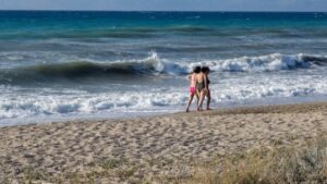
The return of the melter will also bring relief from the heat and favorable conditions for most coastal areas, according to Thodoros Kolydas.
In a post on social media, the Star meteorologist notes that winds will initially increase to 6 to 7 Beaufort in the central and southern Aegean and the peak is expected from Thursday to Sunday, where in some places – mainly in areas such as the Cyclades, Karpathos and the southeastern Aegean – the gusts of wind gusts will reach 7 to 8 Beaufort.
“As it is not accompanied by thunderstorms or unstable weather conditions, it is characterized as a stable, cool and – ultimately – beneficial phenomenon for the days to come,” he notes.
According to ERT’s meteorologist, Anastasia Tyraski yesterday was the last day we had storms, as from today we will have a different day, with good weather and with strengthening north winds that will reach 7 to 8 Beaufort in the Aegean Sea and in the Ionian Sea, where they will reach 5 to 6 Beaufort. There the north wind will continue in the following days, i.e. on Friday and weekend.
Very high fire danger today in 6 regions
According to the Fire Risk Prediction Map issued by the General Secretariat of Civil Protection of the Ministry of Climate & Civil Protection, very high
(risk category 4) for the following areas:
Region of Attica
Region of Peloponnese (Region of Corinth, Region of Argolida, Region of Arcadia, Region of Laconia)
Region of Central Greece (PE Fthiotida, PE Boeotia, PE Fokida, PE Evia including the island of Skyros)
Region of Crete
Region of North Aegean (PE Lesvos, PE Chios, PE Samos, PE Ikaria)
Region of South Aegean (Regional Units of Cyclades)
Drought index in Greece at the beginning of August 2025
The map below depicts the drought index in Greece on 1 August 2025, according to the analysis of the EAA METEO team. As can be seen, with the exception of several areas of Macedonia, Thessaly and central Central Central Greece, the country is in drought conditions. Large parts of Crete, the Peloponnese, eastern Macedonia, Thrace and Lesvos are affected by severe or extreme drought (levels 4 and 5). Many areas of Attica, Evia, western Central Greece and Epirus are in a moderate or severe drought (levels 2 and 3), as well as many of the country’s islands. Following the particularly high temperatures and low rainfall in July, almost all of the country is in a higher-than-seasonal drought level than at the beginning of last month.
The assessment of drought conditions is based on soil moisture in the layer between 28 and 100 cm below the surface. The water content in this layer is critical to the growth and performance of many agricultural crops and reflects the effect of precipitation, evapotranspiration, and soil water runoff/infiltration over a relatively long period of time. When soil moisture in this layer is well below the seasonally normal levels for a particular region, this implies (relative) drought conditions and thus prolonged water stress for crops.
Based on soil moisture data from the European Union’s Copernicus service, we calculate the normalized soil moisture variance index (SSMI) taking into account current conditions as well as those during the reference period 1991-2020. Depending on the value of this index, we classify drought into levels 1 to 5, which in turn indicate mild, moderate, significant, severe and extreme drought. These situations have a relative rather than an absolute meaning. For example, if the soil moisture is low enough for a region at a particular time of year, then we may have up to extreme drought without the soil being completely dry. In cases where the SSMI is slightly negative or positive, then we are in normal conditions for the season, while if it is significantly positive then we have a surplus of moisture in the soil. It should be noted that in the absence of field observations, soil moisture values are an estimate of a specialized model for the Earth’s surface (ERA5-Land) and in some places there may be deviations from actual conditions.
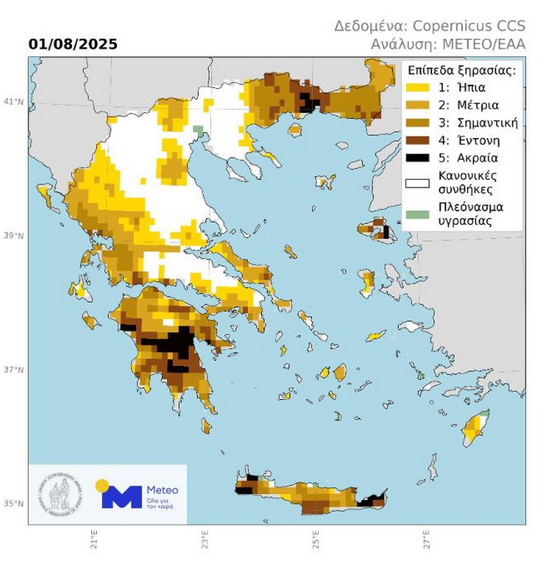
(Figure 1. Drought levels in Greece on 1 August 2025. Areas in a relative drought state are coloured according to the 5-point scale at the top right of the map. Areas where soil moisture is significantly above normal levels are depicted in green, while areas with soil moisture close to the mean are depicted in white.)
Today’s weather
Sunshine is forecast with a few clouds, increasing in Eastern Macedonia, Thrace, Evia, northern and mountainous parts of Crete, as well as in the mountainous mainland during the warm hours of the day, with local rain or isolated thunderstorms in the mountains of Crete, Macedonia and Western Thessaly.
The temperature will range from 22 to 37 degrees in Northern Greece (in Western Macedonia from 16 to 31 degrees), 25 to 35 degrees in Central and Southern Greece (in Thessaly up to 37 degrees), 21 to 37 degrees in Western Greece, 25 to 31 degrees in the Cyclades and Crete, 25 to 35 degrees in the East Aegean islands and 25 to 31 degrees in the Dodecanese.
The winds will blow in the Aegean Sea from the northern directions, moderate to strong 5-6 Beaufort, while in the Ionian Sea from variable directions, light and from noon onwards from northwestern directions, occasionally moderate 4-5 Beaufort.
We expect sunshine with a few clouds in the northern parts on Thursday in Attica. The temperature will range from 27 to 33 degrees Celsius, but in the north and east it will be 2-3 degrees lower. Winds will blow from the north, moderate 4-5 Beaufort and in the east strong 6 Beaufort.
Sunshine with a few clouds, denser in the afternoon and evening hours with local rain or isolated thunderstorms mainly in the surrounding mountains are expected on Thursday in Thessaloniki. The temperature will range from 24 to 37 degrees Celsius. The winds in Thermaikos will blow generally from northwestern directions, light and in the morning hours occasionally moderate 4-5 Beaufort.
The weather on Friday, August 8
Generally clear weather with occasional clouds in northern Crete and in the midday-afternoon hours in Macedonia and in the mountains of Epirus and Thessaly.
Winds will blow north northeast, in the west 4 to 6, in the east 6 to 7 and in the Aegean Sea 8 Beaufort.
The temperature will not change significantly. It will reach 35 to 37 degrees Celsius in the Ionian Islands and the mainland and 30 to 33 degrees Celsius in the rest of the island country and 34 to 35 degrees Celsius locally in southern Crete and the Dodecanese.
The weather on Saturday, August 9
Generally clear weather.
Winds will blow from the north, in the west 4 to 5 and in the Ionian Sea occasionally 6 Beaufort, in the east 6 to 7 and in the Aegean Sea locally 8 Beaufort.
The temperature will rise.
The weather will be mild, with a slight increase in temperature and a slight increase in wind speed.
The weather on Sunday, August 10
The weather will be clear.
Winds will blow from the north, in the west 4 to 5 and in the Ionian Sea occasionally 6 Beaufort, in the east 6 to 7 and in the Aegean Sea locally 8 Beaufort.
The temperature will rise slightly further.
The weather will be more pleasant in the summer and in the winter.
Civil Protection recommendations to citizens
At the same time, the GSP recommends that citizens should be particularly careful and avoid actions in the open air that can cause a fire by negligence, such as burning dry grass and branches or cleaning debris, the use of machinery that cause sparks such as circular saws, welding devices, the use of outdoor barbecues, smoking bees, throwing lit cigarettes, etc. It is also reminded that during the fire season, burning of fields is prohibited.
Accordingly, as announced by the Fire Service, the 2nd stage of the operational readiness of the Fire Service remains in effect and aerial surveillance patrols will be carried out, as well as patrols by fire, police and military forces.
In addition, the personnel of the Fire Services of the above areas remain on partial alert in order to cope with the increased service requirements that may arise due to the very high fire risk (risk category 4).
At the same time, for these areas, the Civil Protection Action Plan for dealing with forest fire risks remains in force, according to which, among other things, the implementation of the measure of preventive prohibition of vehicle traffic and stay of excursionists in national parks, forests and “vulnerable” areas is foreseen.
At the same time the Fire Brigade appeals to citizens:
1. to be particularly careful and avoid actions in the open air that can cause a fire by negligence, such as burning dry grass and branches or cleaning debris, the use of machinery that cause sparks such as circular saws, welding devices, the use of outdoor barbecues, smoking bees, throwing lit cigarettes, etc.;
It is also reminded that during the fire season, burning of fields is prohibited.
2. to follow the information on forest fire prevention available on the website and official accounts of the Fire Department, Facebook and Twitter.
3. In case they become aware of a fire, they are requested to immediately notify the Fire Service on the call number 199.
Finally, it calls on all citizens to be particularly careful and in case of fire, for their own safety, to follow the instructions of the competent authorities.
For more information and instructions for self-protection from the dangers of forest fires, citizens can visit the website of the General Secretariat for Civil Protection at www.civilprotection.gr.
Ask me anything
Explore related questions


