
The weather is expected to deteriorate during Thursday and Friday due to a low-pressure system approaching Greece from the west.
According to the latest forecast data from meteo.gr/National Observatory of Athens, the main characteristics will be:
– locally heavy rain and thunderstorms,
– a significant drop in temperature.
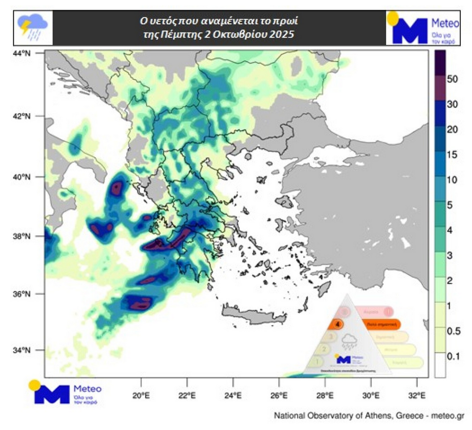
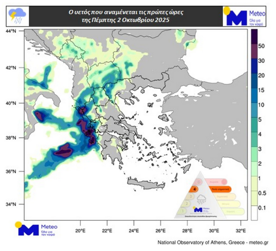
More specifically, from Wednesday night (October 1), rain and thunderstorms are expected in the Ionian Sea. From the early hours of Thursday (October 2), the phenomena will spread to the mainland, except for Eastern Macedonia and Thrace.
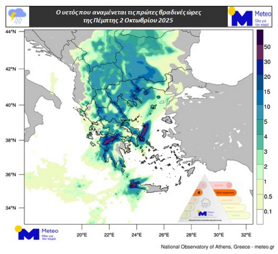
Eastern Macedonia and Thrace, the northern Aegean, the Cyclades, and Crete are expected to be affected from Thursday noon. The phenomena will be locally strong in the Ionian and the western mainland until the afternoon of the same day, in the Peloponnese from the early hours until the evening, and in Eastern Central Greece, parts of Central and Eastern Macedonia, the Northern Aegean, and Crete from Thursday afternoon.
The maps below show the expected precipitation during the early hours, morning, and early evening of Thursday.
Regarding Friday (October 3), the phenomena will mainly affect Central and Eastern Macedonia, Thrace, the Aegean, and Crete, and will be locally strong.
Temperatures will drop significantly on Thursday in the northwest and on Friday in the rest of the country. The drop will locally exceed 10°C.
It is also worth noting:
– From Thursday night (October 2), the first snowfalls of autumn will occur in the mountainous areas of the northwestern mainland, mainly in parts of Western Macedonia.
– Thunderstorms in the Ionian, the Aegean, and the southern mainland will in some cases be accompanied by hail.
– Winds will strengthen and locally reach 7 Beaufort.
– There is a possibility of severe phenomena in Attica, mainly from Thursday noon.
According to the classification of rainfall episodes (Regional Precipitation Index) applied by the Meteo unit of the National Observatory of Athens, the rainfall episode for Thursday, October 2, is classified as Category 4 (Very Significant).
Detailed Weather for Thursday (according to EMY)
Initially in the Ionian, Epirus, Western Macedonia, Western Central Greece, and Western and Southern Peloponnese, and quickly in the rest of the mainland, Evia, the Sporades, the northern Aegean, and from the late morning in the western Cyclades and western Crete, increased cloud cover with rain and scattered thunderstorms is forecast, which will be locally strong. In the Dodecanese, the eastern Cyclades, and eastern Crete, the weather will initially be fair, but from noon cloud cover will develop, and by night local rains and gradually scattered thunderstorms will occur.
Winds in the west will initially blow from the south-southeast at 4–6 Beaufort, shifting to north-northwest in the northern Ionian after the afternoon, locally reaching 7 Beaufort. In the east, winds will initially blow from the north at 3–4 Beaufort and gradually shift to southerly at 4–6 Beaufort, while in the northern Aegean they will be easterly at 4–6 Beaufort, becoming northwesterly from the west during the evening with the same intensity.
Temperatures will drop throughout the country. In the north, they will not exceed 17–19°C; in the Ionian and the rest of the mainland, 22–24°C; and only in the Dodecanese, Cyclades, and Crete will they reach 25–27°C.
Ask me anything
Explore related questions


