Day by day, spring is making its presence more noticeable, with temperatures rising and instability limited to mountainous regions.
According to Giorgos Tsatraphyllias, meteorologist for protothema.gr, in terms of weather developments, besides the temperature increase, muddy rain is also on the way. Additionally, toward the end of the week, a warm spell will push temperatures to unusually high levels for the season. From Friday, the transport of Saharan dust will also be favored.
In more detail:
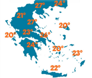
For today, Wednesday 6/5/2026, generally fair weather is expected, with the exception of midday instability in central and northern mountainous areas, mainly in eastern Macedonia and Thrace.
Maximum temperatures will reach 26–27°C in central and northern mainland regions and around 23°C in the Dodecanese. In the evening, temperatures will not drop below 15–16°C in low-lying coastal areas.
Winds in the Ionian Sea will be southwesterly up to 4 Beaufort. In the Aegean, winds will be westerly to southwesterly at similar intensity.
In Athens, sunny conditions are expected. Winds will be southerly up to 4 Beaufort, with temperatures ranging from 13 to 25°C.
In Thessaloniki, partly cloudy conditions are expected. Winds in the Thermaic Gulf will be light, and temperatures will range from 12 to 25°C.
On Thursday, southerly winds will strengthen slightly, rainfall will be minimal, and temperatures will remain at similar levels. On Friday and Saturday, southerlies will intensify, favoring the transport of African dust and bringing muddy rain to central and northern regions.
From Sunday, with dust still present, temperatures will rise further. It is not ruled out that at the beginning of next week temperatures may exceed 32–33°C. The picture will become clearer over the next 24 hours.
Ask me anything
Explore related questions


