After early summer-like conditions, starting today temperatures will gradually return to more normal seasonal levels, according to meteorologist Giorgos Tsatrafyllias of protothema.gr, while afternoon showers are bringing springtime instability back into the spotlight.
More specifically:
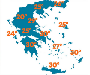
For today, Wednesday 13 May 2026, we expect partly cloudy skies, which after midday will bring rain and scattered thunderstorms mainly in the north, especially in mountainous areas.
Temperatures will drop and reach around 30°C in the eastern and southern mainland, Crete, and the Dodecanese, and 24–25°C in western and northern regions.
Winds in the Ionian Sea will blow from the southwest at up to 4 Beaufort. In the Aegean, winds will be southerly and southwesterly, reaching up to 6 Beaufort in the southern areas.
In Attica, partly cloudy conditions are expected. Winds will be light, and temperatures will range from 17°C to 28°C.
In Thessaloniki, rain and thunderstorms are expected after midday. Winds in the Thermaic Gulf will be light, and temperatures will reach up to 25°C.
On Thursday, rainfall will be more widespread mainly in the mainland and the eastern Aegean, while on Friday and over the weekend, rains will gradually decrease.
Despite small fluctuations, temperatures will remain close to seasonal averages. No, we will not get cold—we are simply returning from early summer back to a typical spring.
Ask me anything
Explore related questions


