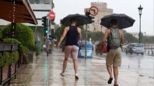
Problems mainly in areas of Thessaly and northern Greece were caused yesterday by a wave of bad weather that will persist today.
According to the updated weather bulletin of the EMY, heavy showers and thunderstorms are expected in some areas today (21-6-2025), accompanied by strong winds at times.
– In Halkidiki, Sporades and Magnesia from early morning until early afternoon.
– In Central Greece (mainly western and central) and the Peloponnese from mid-morning until the afternoon.
Storm cloud in Thessaly caused a lot of hail
The storm cloud that developed in Thessaly yesterday exceeded 12 kilometers in height, causing hailstorms, according to Thodoros Kolydas.
However, in some extreme cases where the upward wind motions in a storm are strong and persistent, then the tops of these storms can penetrate the stratosphere for a few hundred meters leading to very cold cloud tops as happened today (with overshooting by 1.15°C).”
“Almost every year we observe hail of 2-3 cm in diameter in our country, but on 10 June 2013 when very strong storms hit areas of Imathia and Pieria, hail of up to 8 cm in diameter was observed. This is the largest hail we know of that has been observed in our country at least in the last 30 years,” he added.
According to Kolydas, “there is, however, a press report which states that on June 15, 1956, in the village of Loxada in Karditsa, 46 residents were injured and dozens of domestic animals were killed by unprecedented hail, while in Siatista, 22 people were killed in 1930 by hail the size of eggs. The hail fell on the day of the Holy Spirit in Siatista, Kozani.
Hail in Thessaly
Rainfall, strong winds and in some places hailstones occurred yesterday in areas of Karditsa. In some areas, such as Petrino in the municipality of Palamas, but also in areas of the municipality of Sofades, hail caused damage to crops, according to ERT.
The strong winds caused trees to fall in various areas with the fire brigade operating in three cases, alongside the Karditsa – Trikala road and in the area of Agios Theodoros. Tree falls where Fire Department interventions were required were also in areas of the municipalities of Sofades, Karditsa and Palamas, according to karditsalive.net.
Similar phenomena with strong winds that resulted in tree falls occurred in areas of the prefectures of Trikala and Larissa, while in particular in the municipality of Elassona, hailfall occurred in many areas that damaged crops.
A strong wind “swept” the city of Larissa while several trees fell in various parts of the city. Awnings were torn down, while many pots have been removed from balconies and windows, according to onlarissa.gr.
Storms in Fthiotida and tree falls
A strong passage of bad weather made its way through Fthiotida yesterday afternoon, causing local turbulence, with no serious problems recorded.
The severe weather began shortly after 17:00 and lasted about 35 minutes, with most of the intensity recorded in the area of Domokos and in the north of the prefecture in general. The storm was accompanied by strong winds and electrical activity, with repeated lightning making its presence felt.
Heavy rainfall, hail and very strong winds “swept” villages of the plain, such as Neo Monastery, Sofiada, Vardali, Agrapidia, Petrilia and Thaumakos. Residents say it was an unusually intense weather event of short duration, but it caused a great deal of damage.
The farmers’ initial findings are disheartening. Crops were completely destroyed, trees were uprooted or broken by the strong wind, and the amount of water and hail that fell in a matter of minutes destroyed some of the production.
The bad weather wave made a strong brief presence in the east of Fthiotida and phenomena were observed in the area of Stylida, in Raches and Pelasgia, where there were also tree falls, but no damage was reported.
Hail in mountainous Corinthia
A heavy hailstorm occurred on Friday afternoon in the village of Lavka Stymphalia in mountainous Corinthia, causing damage to vegetables as well as vines in the area, according to korinthostv.gr.
Thunderstorms occurred on Friday 06/20/06, mainly in the continental parts of the country. The phenomena were also accompanied by significant electrical activity.
According to the recordings of the Lightning Imager instrument of the Meteosat-12 weather satellite, 18,924 electrical discharges were recorded over the territory of Greece from the beginning of the twenty-four hour period until 21:40 GMT. Electrical discharges are defined as the sum of these including lightning (cloud-to-ground discharges), cloud-to-cloud discharges and cloud-to-air discharges.
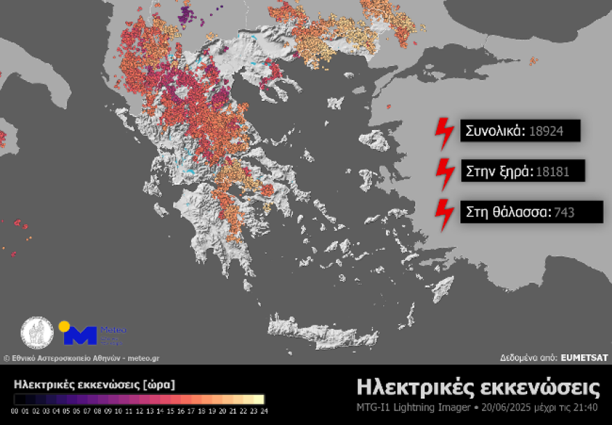
(Figure 1. Electrical discharges over Greece from the Lightning Imager instrument of the Meteosat-12 weather satellite, from the beginning of the twenty-four hour period until 21:40 GMT)
In addition, large amounts of rain were recorded on the mainland and mainly in Central and Northern Greece. The highest rainfall up to 22:00 GMT was recorded in Agii Theodoroi of Grevena and was equal to 93.8 mm.
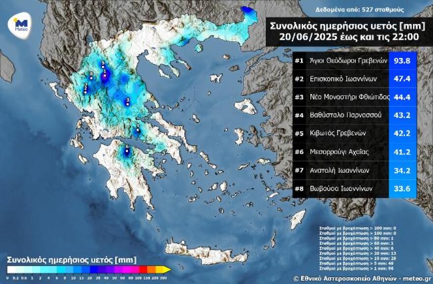
(Figure 2. Total daily precipitation from the automatic weather stations of the National Observatory of Athens – meteo.gr network up to 22:00 GMT)
The weather today
Sunshine is forecast with a few clouds, increasing in the east and from noon in the rest of the mainland and in the mountains of Crete, with local showers in the morning hours in Eastern Thessaly (Magnesia), Sporades, Evia, Eastern Central Greece and possibly in Central Macedonia (Halkidiki), while during the afternoon and evening hours local rain and thunderstorms will occur in the mountains of Epirus, Western and Central Central Central Greece, the Peloponnese and possibly in the mountains of Crete. The phenomena in the Peloponnese will be intense in places and there will be hailstorms, while by the evening they will have stopped.
The temperature will range from 21 to 34 degrees in Northern Greece (in Western Macedonia from 15 to 28 degrees), 25 to 32 degrees in Central and Southern Greece (in Thessaly locally up to 34 degrees), 18 to 35 degrees in Western Greece, 22 to 32 degrees in the Cyclades and Crete, 22 to 34 degrees in the East Aegean islands and 25 to 32 degrees in the Dodecanese.
The winds will blow in the Aegean from northern directions moderate 4-5 Beaufort, while in the Ionian Sea from variable directions light and after noon from northwestern directions almost moderate 4 Beaufort and in the Northern Ionian Sea locally moderate 5 Beaufort.
A few clouds, increasing in the morning hours, with the possibility of occasional rain in the northern parts of the prefecture are expected on Saturday in Attica. The temperature will range from 27 to 32 degrees Celsius, but in the north and east it will be 3-4 degrees lower. Winds will blow from northerly directions, light to almost moderate 3-4 Beaufort and in the east moderate 5 Beaufort.
We expect sunshine with a few clouds on Saturday in Thessaloniki. The temperature will range from 23 to 34 degrees Celsius. The winds in Thermaikos will initially blow from the northwest directions, almost moderate 4 Beaufort, which will quickly weaken and blow lightly from variable directions.
The weather on Sunday, June 22
In central Macedonia and eastern Thessaly a few clouds, partly cloudy with local rain or rain mainly in the midday – afternoon hours. In the rest of the country generally clear weather and only in places on the mainland and the Ionian Sea in the midday – afternoon hours will develop occasional clouds and in the western mountains and in the Ionian Sea there will be local rainfall.
The winds in the west will blow from eastern directions 3 to 5 and from the afternoon west northwest with the same intensity. In the east will blow from the north 4 to 6 Beaufort and in the Aegean Sea 7 and locally 8 Beaufort.
The temperature will drop slightly further, mainly in the east and will reach 30 to 31 degrees Celsius in the mainland and the Ionian Sea and 26 to 28 degrees Celsius in the sea.
Ask me anything
Explore related questions


