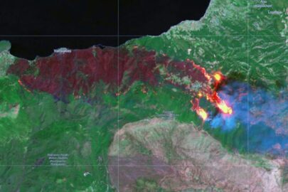
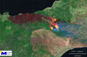
The Sentinel-2 satellite captured the fire that burn the forests of Corinth.
The satellite passed on Thursday morning (20/5) over Western Attica and Eastern Corinth and captured the burned area, as well as the active fronts of the fire that were directed towards Megara, destroying everything in their path.
According to the National Observatory of Athens, the satellite image and the estimate of the European Emergency Service Copernicus – EMS, more than 25,000 acres of forest had been reduced to ashes shortly before noon on Thursday.
This assessment was made before the afternoon strengthening of the winds in the area, which resulted in the destructive work of the fire in Corinth to become even bigger, reaching near Megara and the burned forest up to 40.000 acres.
Israel and Hamas agreed to a cease-fire
Two bases in Turkey attacked by ‘model aircraft’
Ask me anything
Explore related questions


