Temperatures will rise in the coming days, with the heatwave peaking on Friday, according to meteorologists. Heatwave conditions will prevail mainly in mainland areas, with temperatures reaching 40 to 41°C in typically hot parts of the country.
Ξεκινά τριήμερο ζέστης από την Τετάρτη με κορύφωση την Παρασκευή . Αναλυτικά στο κεντρικό Δελτίο Ειδήσεων του @Starchannelnew1 pic.twitter.com/vWso7babTC
— Theodoros Kolydas (@KolydasT) June 23, 2025
As Theodoros Kolydas notes in a post: “A three-day heatwave starts on Wednesday, peaking on Friday.”
Tsatrafyllias warns of very high fire risk
“A devil’s week with a very high risk of fires,” warns meteorologist Giorgos Tsatrafyllias from Alpha TV. He states that fire-weather conditions will become even more adverse in the coming days, as after the heatwave (Wednesday–Friday), gale-force north winds will follow (Saturday–Sunday).
In a previous post, Tsatrafyllias mentioned the seven regions of the country that will be most affected by the heatwave, where temperatures will rise dangerously:
- Thessaly
- Kilkis
- Serres
- Peloponnese
- Boeotia
- Aetolia-Acarnania
- Attica
Express heatwave approaching – What Kallianos says
Temperatures will start rising gradually from today (June 24, 2025), reaching up to 37°C. On Wednesday, it will get even hotter, according to Giannis Kallianos in a social media post about the coming heatwave.
His forecast indicates that hot air masses from North Africa will cover the entire Mediterranean, leading to a heatwave lasting 3 to 4 days.
Predicting temperatures in major Greek cities, he notes that Attica will scorch at 40°C on Friday, while Larissa will hit 42°C.
Indicative temperatures:
Attica
- Tue: 36°C
- Wed: 37-38°C
- Thu: 38-39°C
- Fri: 39-40°C
Thessaloniki
- Tue: 34°C
- Wed: 37°C
- Thu: 38-39°C
- Fri: 37-38°C
Patras
- Tue: 33°C
- Wed: 35°C
- Thu: 37-38°C
- Fri: 37-38°C
Heraklion
- Tue: 31°C
- Wed: 33°C
- Thu: 36°C
- Fri: 36°C
Larissa
- Tue: 36-37°C
- Wed: 38-39°C
- Thu: 40-41°C
- Fri: 41-42°C
Today’s weather
Clear skies are expected, with some local cloud development at noon and in the afternoon, mainly in mountainous mainland areas.
Temperatures:
- Western Macedonia: 13-31°C
- Rest of Macedonia, Thrace, Thessaly: 19-36°C
- Epirus: 17-33°C
- Central Greece, Peloponnese: 16-35°C
- Ionian islands: 18-34°C
- North & East Aegean islands: 17-36°C
- Cyclades: 19-33°C
- Dodecanese: 16-32°C
- Crete: 17-33°C
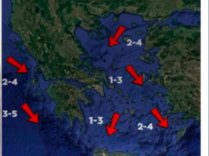
Winds:
- North Aegean: N 2-4 Beaufort
- Thermaikos & Sporades: Variable up to 3 Beaufort by midday
- Central Aegean: N 2-4 Beaufort
- South Aegean: Initially N 3-5, shifting to W 2-4 Beaufort
- Ionian: NW 2-4 Beaufort
Attica: Clear skies, N winds 2-4 Beaufort, variable midday-afternoon up to 3 Beaufort, 23-35°C
Thessaloniki: Clear skies, variable winds up to 3 Beaufort, 24-34°C
Wednesday, June 25 weather
Generally clear. Temporary clouds over mountainous Macedonia and Epirus in the afternoon.
N winds 3-5, up to 6 Beaufort in the eastern Aegean.
Temperature up to 37-39°C inland, 35-37°C Ionian/eastern Aegean/south Crete, 31-33°C other islands.
Thursday, June 26 weather
Generally clear. Some local clouds in mainland mountains in the afternoon.
N winds 3-5, locally 6 Beaufort central/southern Aegean.
Temperatures slightly higher, reaching very high levels.
Friday, June 27 weather
Generally clear. Afternoon clouds inland, with possible local showers or storms in central/northern mountains.
N winds 3-5, up to 6 Beaufort in the seas.
Temperatures remain high for the season.
Saturday, June 28 weather
Generally clear.
N winds 4-5, 6-7 Beaufort at sea.
Temperatures drop by 2-3°C.
Ask me anything
Explore related questions


