The weather does not seem to be changing its pattern, according to protothema.gr meteorologist Giorgos Tsatrafyllias.
The day will start off sunny, but from midday onwards clouds will develop and local showers and thunderstorms will occur. These phenomena are very likely to be accompanied by hail and increased lightning activity. In fact, instability will peak over the weekend.
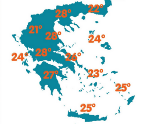
More specifically:
For today, Friday 22 May, once again mainly in the afternoon and evening, rain and scattered thunderstorms are expected in mainland areas and in the eastern and southern island regions.
Maximum temperatures will reach 27–28°C in mainland Greece and around 25°C in Crete and the Dodecanese. At night, in lowland areas, temperatures will not drop below 17°C.
Winds will blow from the northwest reaching up to 5 Beaufort in the Ionian and Aegean Seas.
In Attica, after midday, rain and scattered thunderstorms are expected. Winds will be northwesterly up to 3 Beaufort, while temperatures will range between 15 and 26°C.
In Thessaloniki, from midday onwards, unsettled weather with rain and storms is expected. The Vardaris wind will reach 4 Beaufort in the Thermaic Gulf, while temperatures will reach 28°C.
Over the weekend, instability peaks. Rain and thunderstorms will occur mainly in the afternoon and evening in mainland areas as well as in eastern and southern island regions. Locally, the phenomena may be intense, with possible hailstorms and increased lightning activity, while temperatures will remain close to seasonal averages.
Ask me anything
Explore related questions


